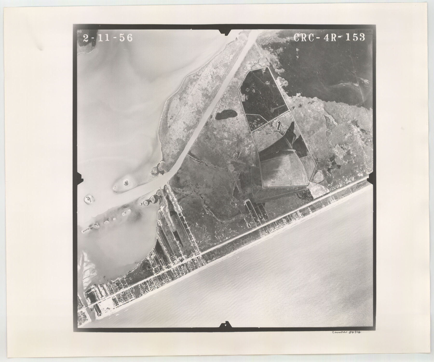
Flight Mission No. CRC-4R, Frame 153, Chambers County
CRC-4R-153
-
Map/Doc
84916
-
Collection
General Map Collection
-
Object Dates
1956/2/11 (Creation Date)
-
People and Organizations
U. S. Department of Agriculture (Publisher)
-
Counties
Chambers
-
Subjects
Aerial Photograph
-
Height x Width
18.7 x 22.4 inches
47.5 x 56.9 cm
-
Comments
Flown by Jack Ammann Photogrammetric Engineers, Inc. of San Antonio, Texas.
Part of: General Map Collection
Cass County Working Sketch 47a

Print $20.00
- Digital $50.00
Cass County Working Sketch 47a
1991
Size 29.5 x 39.5 inches
Map/Doc 67950
Presidio County Sketch File 32

Print $8.00
- Digital $50.00
Presidio County Sketch File 32
1885
Size 11.2 x 8.7 inches
Map/Doc 34472
Val Verde Co.

Print $20.00
- Digital $50.00
Val Verde Co.
1908
Size 40.5 x 38.4 inches
Map/Doc 63099
New Map of Texas prepared and published for the Bureau of Immigration of the State of Texas

Print $20.00
- Digital $50.00
New Map of Texas prepared and published for the Bureau of Immigration of the State of Texas
1875
Size 15.8 x 18.3 inches
Map/Doc 93626
Pecos County Sketch File 19

Print $4.00
- Digital $50.00
Pecos County Sketch File 19
Size 14.2 x 8.8 inches
Map/Doc 33668
Reeves County Sketch File 22

Print $4.00
- Digital $50.00
Reeves County Sketch File 22
Size 14.3 x 8.7 inches
Map/Doc 35220
Upton County Rolled Sketch 15

Print $20.00
- Digital $50.00
Upton County Rolled Sketch 15
1927
Size 25.0 x 19.2 inches
Map/Doc 8070
Gillespie County

Print $20.00
- Digital $50.00
Gillespie County
1873
Size 16.0 x 22.4 inches
Map/Doc 3580
Webb County Sketch File 5

Print $8.00
- Digital $50.00
Webb County Sketch File 5
1876
Size 12.8 x 8.1 inches
Map/Doc 39725
Flight Mission No. BQY-4M, Frame 36, Harris County

Print $20.00
- Digital $50.00
Flight Mission No. BQY-4M, Frame 36, Harris County
1953
Size 18.6 x 22.3 inches
Map/Doc 85251
Lavaca County Sketch File 6

Print $2.00
- Digital $50.00
Lavaca County Sketch File 6
Size 7.3 x 3.2 inches
Map/Doc 29641
Val Verde County Sketch File A1

Print $6.00
- Digital $50.00
Val Verde County Sketch File A1
1895
Size 14.4 x 9.2 inches
Map/Doc 39038
You may also like
Edwards County Working Sketch 34

Print $20.00
- Digital $50.00
Edwards County Working Sketch 34
1948
Size 39.2 x 23.3 inches
Map/Doc 68910
Bell County Sketch File 17

Print $4.00
- Digital $50.00
Bell County Sketch File 17
Size 8.1 x 9.1 inches
Map/Doc 14398
Pecos County Rolled Sketch 108

Print $20.00
- Digital $50.00
Pecos County Rolled Sketch 108
1940
Size 39.7 x 30.7 inches
Map/Doc 7254
Hutchinson County Rolled Sketch 43

Print $40.00
- Digital $50.00
Hutchinson County Rolled Sketch 43
1992
Size 40.5 x 49.4 inches
Map/Doc 6316
Johnson County

Print $20.00
- Digital $50.00
Johnson County
1859
Size 22.0 x 29.6 inches
Map/Doc 3732
Fannin County Sketch File 22

Print $6.00
- Digital $50.00
Fannin County Sketch File 22
1883
Size 10.9 x 9.5 inches
Map/Doc 22489
Jones County Sketch File 13

Print $20.00
- Digital $50.00
Jones County Sketch File 13
Size 43.5 x 35.7 inches
Map/Doc 10511
Briscoe County Boundary File 7

Print $6.00
- Digital $50.00
Briscoe County Boundary File 7
Size 10.6 x 8.1 inches
Map/Doc 50806
[Surveying Sketch of T. & N. O. R. R. Co., S. P. R. R. Co., E. T. R. R. Co., et al in Dallam, Hartley, Sherman & Moore Counties, Texas]
![75824, [Surveying Sketch of T. & N. O. R. R. Co., S. P. R. R. Co., E. T. R. R. Co., et al in Dallam, Hartley, Sherman & Moore Counties, Texas], Maddox Collection](https://historictexasmaps.com/wmedia_w700/maps/75824.tif.jpg)
Print $20.00
- Digital $50.00
[Surveying Sketch of T. & N. O. R. R. Co., S. P. R. R. Co., E. T. R. R. Co., et al in Dallam, Hartley, Sherman & Moore Counties, Texas]
Size 17.5 x 22.1 inches
Map/Doc 75824
Yoakum County Sketch File 8

Print $20.00
- Digital $50.00
Yoakum County Sketch File 8
Size 25.6 x 29.3 inches
Map/Doc 12705
[Cotton Belt, St. Louis Southwestern Railway of Texas, Alignment through Smith County]
![64377, [Cotton Belt, St. Louis Southwestern Railway of Texas, Alignment through Smith County], General Map Collection](https://historictexasmaps.com/wmedia_w700/maps/64377.tif.jpg)
Print $20.00
- Digital $50.00
[Cotton Belt, St. Louis Southwestern Railway of Texas, Alignment through Smith County]
1903
Size 21.7 x 30.0 inches
Map/Doc 64377
[Right of Way & Track Map, The Texas & Pacific Ry. Co. Main Line]
![64681, [Right of Way & Track Map, The Texas & Pacific Ry. Co. Main Line], General Map Collection](https://historictexasmaps.com/wmedia_w700/maps/64681.tif.jpg)
Print $20.00
- Digital $50.00
[Right of Way & Track Map, The Texas & Pacific Ry. Co. Main Line]
Size 11.0 x 19.0 inches
Map/Doc 64681