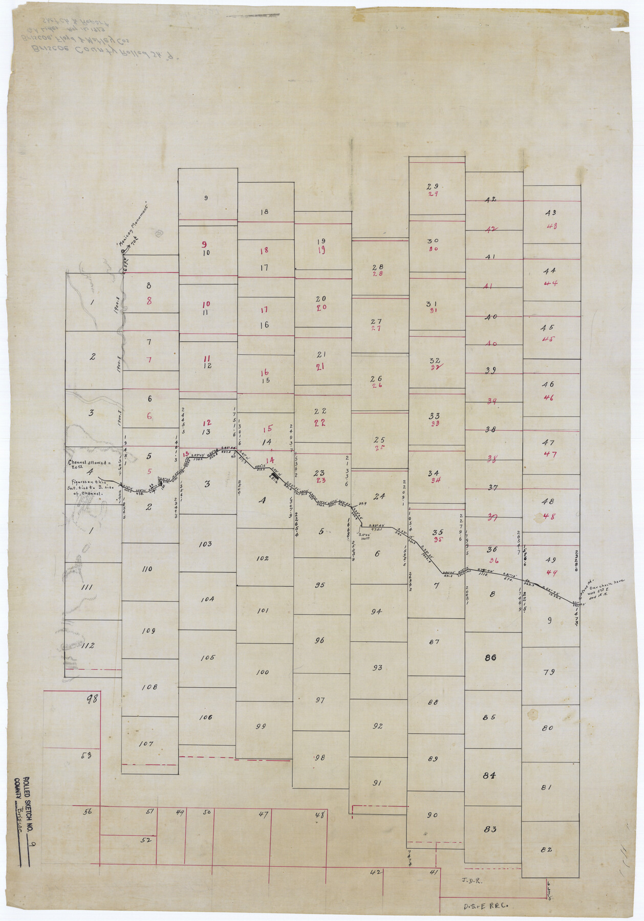
Briscoe County Rolled Sketch 9
[Sketch of surveys in Briscoe, Floyd & Motley Cos.]
-
Map/Doc
5327
-
Collection
General Map Collection
-
Object Dates
1913/5/16 (File Date)
-
Counties
Briscoe Floyd Motley
-
Subjects
Surveying Rolled Sketch
-
Height x Width
30.6 x 21.4 inches
77.7 x 54.4 cm
-
Medium
linen, manuscript
-
Comments
See Briscoe County Sketch File 16 (16535) for surveyor’s report.
Related maps
Briscoe County Sketch File 16

Print $4.00
- Digital $50.00
Briscoe County Sketch File 16
1913
Size 13.4 x 9.1 inches
Map/Doc 16535
Part of: General Map Collection
Hamilton County Sketch File 10 1/2

Print $44.00
- Digital $50.00
Hamilton County Sketch File 10 1/2
1876
Size 9.2 x 8.3 inches
Map/Doc 24931
Flight Mission No. DQO-8K, Frame 113, Galveston County

Print $20.00
- Digital $50.00
Flight Mission No. DQO-8K, Frame 113, Galveston County
1952
Size 18.6 x 22.5 inches
Map/Doc 85195
Hardin County Working Sketch 12

Print $20.00
- Digital $50.00
Hardin County Working Sketch 12
1934
Size 16.8 x 11.9 inches
Map/Doc 63410
Cottle County Rolled Sketch 14

Print $741.00
- Digital $50.00
Cottle County Rolled Sketch 14
1882
Size 10.8 x 16.0 inches
Map/Doc 42369
Stephens County Working Sketch 41

Print $40.00
- Digital $50.00
Stephens County Working Sketch 41
2008
Size 34.1 x 48.0 inches
Map/Doc 88737
Mason County Working Sketch 7

Print $20.00
- Digital $50.00
Mason County Working Sketch 7
1945
Size 35.8 x 43.9 inches
Map/Doc 70843
Wheeler County Sketch File 9

Print $12.00
- Digital $50.00
Wheeler County Sketch File 9
1989
Size 11.8 x 9.1 inches
Map/Doc 40008
Flight Mission No. CUG-1P, Frame 83, Kleberg County

Print $20.00
- Digital $50.00
Flight Mission No. CUG-1P, Frame 83, Kleberg County
1956
Size 18.5 x 22.2 inches
Map/Doc 86148
Polk County Working Sketch 23b

Print $40.00
- Digital $50.00
Polk County Working Sketch 23b
1957
Size 28.8 x 54.6 inches
Map/Doc 71639
Brewster County Sketch File N-20

Print $40.00
- Digital $50.00
Brewster County Sketch File N-20
1941
Size 16.5 x 20.5 inches
Map/Doc 10967
Armstrong County Working Sketch 7

Print $20.00
- Digital $50.00
Armstrong County Working Sketch 7
Size 18.1 x 16.4 inches
Map/Doc 67238
Bowie County Working Sketch 17

Print $20.00
- Digital $50.00
Bowie County Working Sketch 17
1962
Size 24.5 x 20.0 inches
Map/Doc 67421
You may also like
[Sketch for Mineral Application 33721 - 33725 Incl. - Padre and Mustang Island]
![2873, [Sketch for Mineral Application 33721 - 33725 Incl. - Padre and Mustang Island], General Map Collection](https://historictexasmaps.com/wmedia_w700/maps/2873.tif.jpg)
Print $20.00
- Digital $50.00
[Sketch for Mineral Application 33721 - 33725 Incl. - Padre and Mustang Island]
1942
Size 26.6 x 22.7 inches
Map/Doc 2873

Flight Mission No. DIX-5P, Frame 148, Aransas County

Print $20.00
- Digital $50.00
Flight Mission No. DIX-5P, Frame 148, Aransas County
1956
Size 17.9 x 18.0 inches
Map/Doc 83810
Foard County Sketch File 9

Print $20.00
- Digital $50.00
Foard County Sketch File 9
1882
Size 19.7 x 17.1 inches
Map/Doc 11492
Flight Mission No. DIX-10P, Frame 171, Aransas County

Print $20.00
- Digital $50.00
Flight Mission No. DIX-10P, Frame 171, Aransas County
1956
Size 18.8 x 22.3 inches
Map/Doc 83961
Midland County Sketch File 11

Print $20.00
- Digital $50.00
Midland County Sketch File 11
1936
Size 21.6 x 17.5 inches
Map/Doc 12086
[East and South lines of County]
![93137, [East and South lines of County], Twichell Survey Records](https://historictexasmaps.com/wmedia_w700/maps/93137-1.tif.jpg)
Print $40.00
- Digital $50.00
[East and South lines of County]
Size 75.7 x 9.0 inches
Map/Doc 93137
Stonewall County Rolled Sketch 23

Print $20.00
- Digital $50.00
Stonewall County Rolled Sketch 23
Size 38.5 x 47.5 inches
Map/Doc 9962
Galveston County NRC Article 33.136 Sketch 29

Print $21.00
- Digital $50.00
Galveston County NRC Article 33.136 Sketch 29
2005
Size 22.4 x 31.9 inches
Map/Doc 83282
General Highway Map, Trinity County, Texas

Print $20.00
General Highway Map, Trinity County, Texas
1961
Size 18.1 x 24.5 inches
Map/Doc 79688
United States - Gulf Coast Texas - Southern part of Laguna Madre

Print $20.00
- Digital $50.00
United States - Gulf Coast Texas - Southern part of Laguna Madre
1933
Size 26.8 x 18.3 inches
Map/Doc 72949
Map of Andrews County

Print $40.00
- Digital $50.00
Map of Andrews County
1900
Size 40.8 x 52.9 inches
Map/Doc 4780