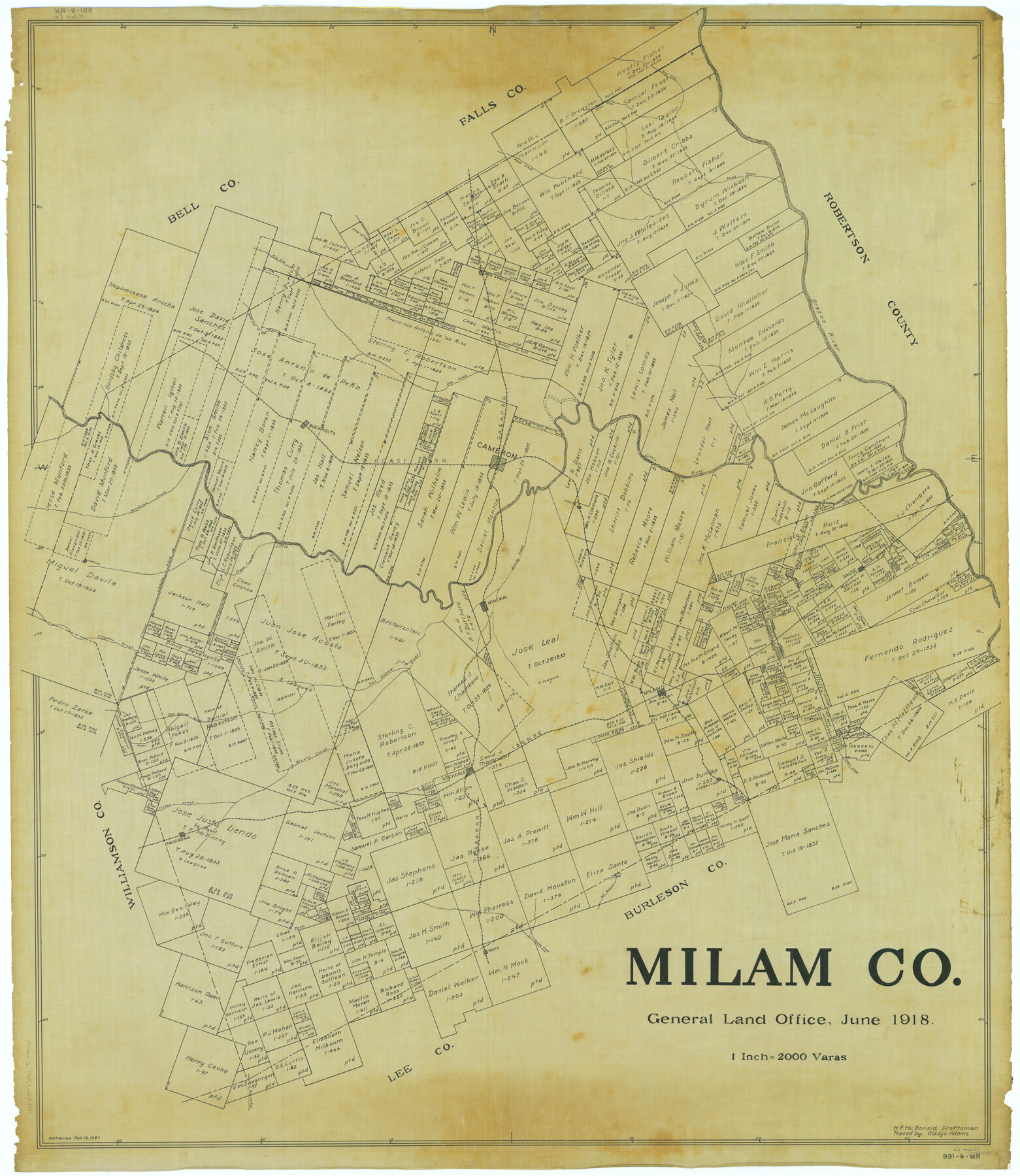
Milam Co.
RM-4-166
-
Map/Doc
66932
-
Collection
General Map Collection
-
Object Dates
1918 (Creation Date)
-
People and Organizations
Texas General Land Office (Publisher)
H.F. McDonald (Compiler)
H.F. McDonald (Draftsman)
-
Counties
Milam
-
Subjects
County
-
Height x Width
48.2 x 41.8 inches
122.4 x 106.2 cm
-
Comments
Traced by Gladys Adams.
Retraced February 19, 1947.
Part of: General Map Collection
Stephens County Sketch File 3

Print $4.00
- Digital $50.00
Stephens County Sketch File 3
Size 8.6 x 10.6 inches
Map/Doc 37015
Flight Mission No. DQO-2K, Frame 142, Galveston County

Print $20.00
- Digital $50.00
Flight Mission No. DQO-2K, Frame 142, Galveston County
1952
Size 18.8 x 22.4 inches
Map/Doc 85039
Fort Bend County Sketch File 3

Print $4.00
- Digital $50.00
Fort Bend County Sketch File 3
Size 12.8 x 8.1 inches
Map/Doc 22880
Montgomery County Sketch File 28

Print $22.00
- Digital $50.00
Montgomery County Sketch File 28
Size 14.1 x 8.7 inches
Map/Doc 31873
Map of Red River County

Print $20.00
- Digital $50.00
Map of Red River County
1856
Size 22.2 x 18.4 inches
Map/Doc 3981
Val Verde County Rolled Sketch 30

Print $20.00
- Digital $50.00
Val Verde County Rolled Sketch 30
1884
Size 43.8 x 26.4 inches
Map/Doc 8111
Jeff Davis County Sketch File 18a

Print $14.00
- Digital $50.00
Jeff Davis County Sketch File 18a
Size 9.3 x 6.0 inches
Map/Doc 27966
Ector County Working Sketch Graphic Index - sheet A

Print $20.00
- Digital $50.00
Ector County Working Sketch Graphic Index - sheet A
1943
Size 44.5 x 39.1 inches
Map/Doc 76530
Donley County Sketch File B1

Print $20.00
- Digital $50.00
Donley County Sketch File B1
Size 32.0 x 21.3 inches
Map/Doc 11371
Flight Mission No. DQN-2K, Frame 27, Calhoun County

Print $20.00
- Digital $50.00
Flight Mission No. DQN-2K, Frame 27, Calhoun County
1953
Size 18.7 x 22.2 inches
Map/Doc 84234
Medina County Working Sketch 11

Print $20.00
- Digital $50.00
Medina County Working Sketch 11
1963
Size 21.8 x 26.5 inches
Map/Doc 70926
Flight Mission No. CRC-2R, Frame 186, Chambers County

Print $20.00
- Digital $50.00
Flight Mission No. CRC-2R, Frame 186, Chambers County
1956
Size 18.7 x 22.4 inches
Map/Doc 84764
You may also like
From Citizens Living in Gonzales and Victoria Counties for the Creation of a New Judicial County to be Called Guadalupe, Undated

Print $20.00
From Citizens Living in Gonzales and Victoria Counties for the Creation of a New Judicial County to be Called Guadalupe, Undated
2020
Size 24.5 x 21.7 inches
Map/Doc 96413
Liberty County Working Sketch 60

Print $20.00
- Digital $50.00
Liberty County Working Sketch 60
1969
Size 41.3 x 34.1 inches
Map/Doc 70520
Midland County Working Sketch 18

Print $40.00
- Digital $50.00
Midland County Working Sketch 18
1956
Size 26.5 x 49.5 inches
Map/Doc 70998
General Highway Map of Garza County, Texas

Print $20.00
- Digital $50.00
General Highway Map of Garza County, Texas
1950
Size 25.9 x 18.8 inches
Map/Doc 92646
Ward County Working Sketch 41

Print $20.00
- Digital $50.00
Ward County Working Sketch 41
1969
Size 45.3 x 31.7 inches
Map/Doc 72347
Kinney County Working Sketch 18

Print $40.00
- Digital $50.00
Kinney County Working Sketch 18
1948
Size 56.7 x 40.5 inches
Map/Doc 70200
Flight Mission No. DAG-24K, Frame 39, Matagorda County

Print $20.00
- Digital $50.00
Flight Mission No. DAG-24K, Frame 39, Matagorda County
1953
Size 18.5 x 22.3 inches
Map/Doc 86526
Flight Mission No. BRA-7M, Frame 15, Jefferson County

Print $20.00
- Digital $50.00
Flight Mission No. BRA-7M, Frame 15, Jefferson County
1953
Size 18.6 x 22.3 inches
Map/Doc 85466
Coleman County Sketch File 45a

Print $4.00
- Digital $50.00
Coleman County Sketch File 45a
1897
Size 9.8 x 6.2 inches
Map/Doc 18791
Hunt County Sketch File 34

Print $6.00
- Digital $50.00
Hunt County Sketch File 34
Size 9.9 x 7.2 inches
Map/Doc 27143
[The S.K. Ry. of Texas, State Line to Pecos, Reeves Co., Texas]
![64163, [The S.K. Ry. of Texas, State Line to Pecos, Reeves Co., Texas], General Map Collection](https://historictexasmaps.com/wmedia_w700/maps/64163.tif.jpg)
Print $40.00
- Digital $50.00
[The S.K. Ry. of Texas, State Line to Pecos, Reeves Co., Texas]
1910
Size 19.3 x 120.2 inches
Map/Doc 64163
[Sketch for Mineral Application 14125 - Neches River, R. B. Moore]
![65668, [Sketch for Mineral Application 14125 - Neches River, R. B. Moore], General Map Collection](https://historictexasmaps.com/wmedia_w700/maps/65668.tif.jpg)
Print $40.00
- Digital $50.00
[Sketch for Mineral Application 14125 - Neches River, R. B. Moore]
1928
Size 50.1 x 26.6 inches
Map/Doc 65668