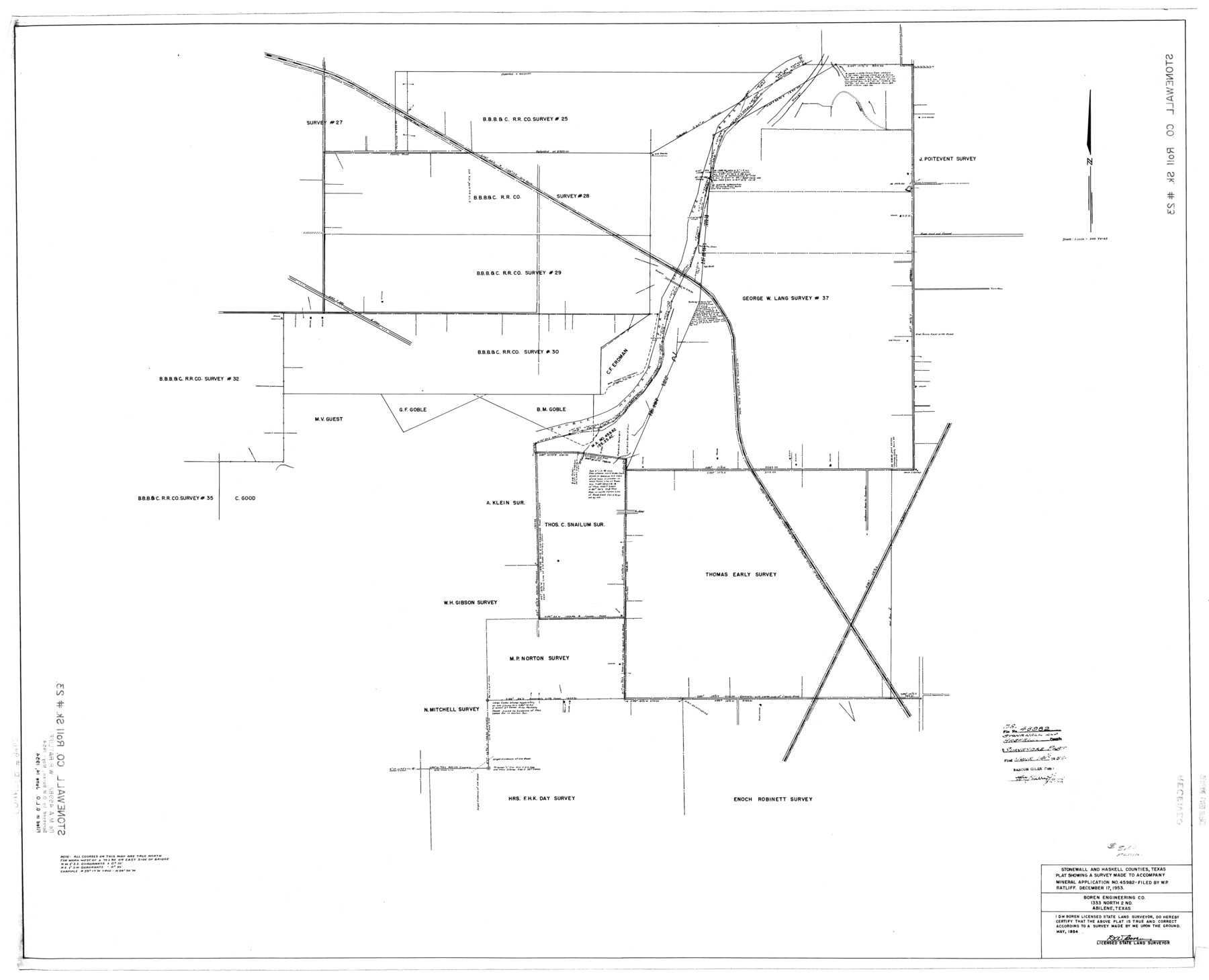
Stonewall County Rolled Sketch 23
Plat showing a survey made to accompany Mineral Application no. 45982
-
Map/Doc
9962
-
Collection
General Map Collection
-
Object Dates
1954 (Survey Date)
1954/6/14 (File Date)
-
People and Organizations
D.W. Boren (Surveyor/Engineer)
-
Counties
Stonewall Haskell
-
Subjects
Surveying Rolled Sketch
-
Height x Width
38.5 x 47.5 inches
97.8 x 120.7 cm
-
Scale
1" = 300 varas
Part of: General Map Collection

Starr County Rolled Sketch 39

Print $20.00
- Digital $50.00
Starr County Rolled Sketch 39
1954
Size 24.9 x 27.7 inches
Map/Doc 7833
Ward County Rolled Sketch 12

Print $20.00
- Digital $50.00
Ward County Rolled Sketch 12
Size 38.2 x 47.8 inches
Map/Doc 10107
Uvalde County Working Sketch 46

Print $20.00
- Digital $50.00
Uvalde County Working Sketch 46
1979
Size 37.1 x 26.3 inches
Map/Doc 72116
Red River County Working Sketch 48

Print $20.00
- Digital $50.00
Red River County Working Sketch 48
1970
Size 28.6 x 30.2 inches
Map/Doc 72031
Jack County Sketch File 33

Print $20.00
- Digital $50.00
Jack County Sketch File 33
Size 19.5 x 21.4 inches
Map/Doc 11831

Falls County Sketch File 1

Print $4.00
- Digital $50.00
Falls County Sketch File 1
1852
Size 10.7 x 8.6 inches
Map/Doc 22330
Moore County Rolled Sketch 8

Print $20.00
- Digital $50.00
Moore County Rolled Sketch 8
1912
Size 33.7 x 35.2 inches
Map/Doc 9548
Stephens County Sketch File 23

Print $12.00
- Digital $50.00
Stephens County Sketch File 23
1919
Size 11.1 x 8.8 inches
Map/Doc 37084
Nolan County Rolled Sketch 3

Print $20.00
- Digital $50.00
Nolan County Rolled Sketch 3
Size 27.9 x 26.2 inches
Map/Doc 6864
Jeff Davis County Working Sketch 47

Print $20.00
- Digital $50.00
Jeff Davis County Working Sketch 47
2000
Size 30.1 x 40.1 inches
Map/Doc 66542
You may also like
Crockett County Rolled Sketch CRV

Print $40.00
- Digital $50.00
Crockett County Rolled Sketch CRV
1925
Size 35.8 x 52.3 inches
Map/Doc 8693
Harris County

Print $20.00
- Digital $50.00
Harris County
1940
Size 36.8 x 45.2 inches
Map/Doc 77304
General Highway Map, Polk County, Texas

Print $20.00
General Highway Map, Polk County, Texas
1940
Size 24.6 x 18.5 inches
Map/Doc 79219

Gillespie County, Texas

Print $20.00
- Digital $50.00
Gillespie County, Texas
1879
Size 21.2 x 26.9 inches
Map/Doc 547
Jack County Working Sketch 1

Print $20.00
- Digital $50.00
Jack County Working Sketch 1
Size 28.4 x 27.1 inches
Map/Doc 66427
Packery Channel

Print $3.00
- Digital $50.00
Packery Channel
1962
Size 10.6 x 12.8 inches
Map/Doc 3006
Edwards County Working Sketch 116

Print $20.00
- Digital $50.00
Edwards County Working Sketch 116
1973
Size 26.5 x 39.1 inches
Map/Doc 68992
Cass County Working Sketch 27

Print $20.00
- Digital $50.00
Cass County Working Sketch 27
1978
Size 17.5 x 19.7 inches
Map/Doc 67930
Harris County Sketch File 32

Print $14.00
- Digital $50.00
Harris County Sketch File 32
1900
Size 6.7 x 8.8 inches
Map/Doc 25429
Walker County Rolled Sketch 1

Print $20.00
- Digital $50.00
Walker County Rolled Sketch 1
1982
Size 36.3 x 23.6 inches
Map/Doc 8154
Port Facilities at Houston, Tex.

Print $20.00
- Digital $50.00
Port Facilities at Houston, Tex.
Size 14.1 x 30.3 inches
Map/Doc 97167