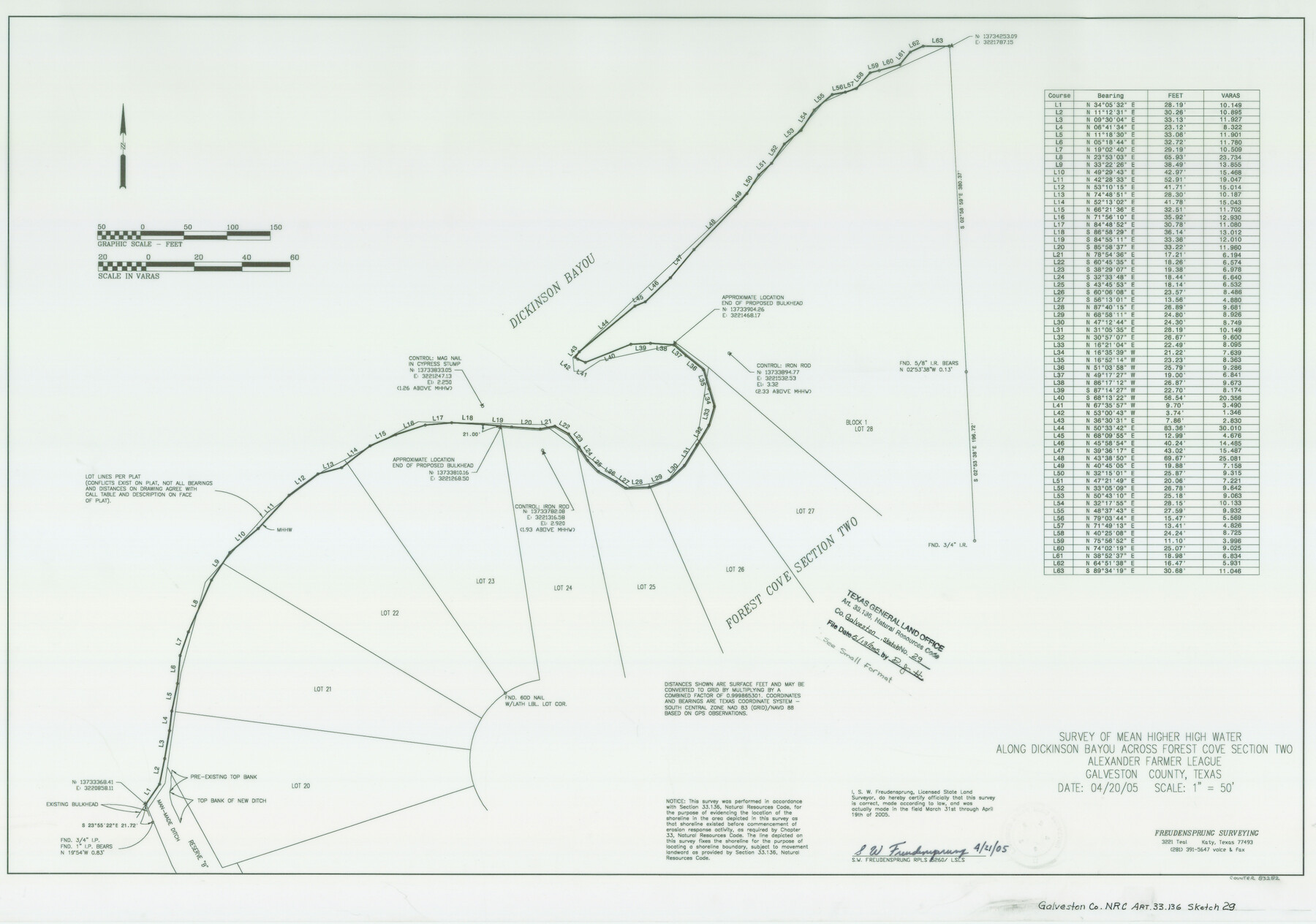
Galveston County NRC Article 33.136 Sketch 29
A Survey of Mean Higher High Water along Dickinson Bayou Across Forest Cove Section Two, Alexander Farmer League
-
Map/Doc
83282
-
Collection
General Map Collection
-
Object Dates
2005/4/20 (Creation Date)
2005/5/13 (File Date)
-
People and Organizations
Freudensprung Surveying Inc. (Publisher)
Freudensprung Surveying Inc. (Printer)
S.W. Freudensprung (Author)
S.W. Freudensprung (Surveyor/Engineer)
-
Counties
Galveston
-
Subjects
Surveying CBS
-
Height x Width
22.4 x 31.9 inches
56.9 x 81.0 cm
-
Medium
multi-page, multi-format
-
Comments
Survey located about 19 1/2 miles North 57 degrees West of Galveston, Texas.
Part of: General Map Collection
Map of Texas Gulf Coast and Texas Continental Shelf showing Natural Gas Pipe Lines

Print $40.00
- Digital $50.00
Map of Texas Gulf Coast and Texas Continental Shelf showing Natural Gas Pipe Lines
1973
Size 41.6 x 60.1 inches
Map/Doc 75904
Webb County Sketch File 13a

Print $20.00
- Digital $50.00
Webb County Sketch File 13a
1881
Size 19.0 x 25.7 inches
Map/Doc 12631
Somervell County

Print $20.00
- Digital $50.00
Somervell County
1941
Size 27.5 x 26.7 inches
Map/Doc 63042
Reeves County Boundary File 73a

Print $16.00
- Digital $50.00
Reeves County Boundary File 73a
Size 13.3 x 8.2 inches
Map/Doc 58208
Map of parts of Texas, Mexico and New Mexico

Print $4.00
- Digital $50.00
Map of parts of Texas, Mexico and New Mexico
1877
Size 18.1 x 21.8 inches
Map/Doc 65403
Jeff Davis County Sketch File 30

Print $26.00
- Digital $50.00
Jeff Davis County Sketch File 30
1922
Size 14.1 x 8.5 inches
Map/Doc 28014
Stonewall County Working Sketch 13

Print $20.00
- Digital $50.00
Stonewall County Working Sketch 13
1951
Size 31.9 x 33.7 inches
Map/Doc 62320
Garza County Sketch File 4

Print $6.00
- Digital $50.00
Garza County Sketch File 4
1883
Size 12.6 x 11.0 inches
Map/Doc 24046
Navarro County Sketch File 12

Print $4.00
- Digital $50.00
Navarro County Sketch File 12
Size 7.0 x 7.0 inches
Map/Doc 32322
Howard County Sketch File 5

Print $3.00
- Digital $50.00
Howard County Sketch File 5
Size 20.0 x 12.8 inches
Map/Doc 11794
Starr County Working Sketch 13

Print $20.00
- Digital $50.00
Starr County Working Sketch 13
1951
Size 19.3 x 28.8 inches
Map/Doc 63929
[Topographical Map showing part of Miller Day Ranch in Southwest Part of Coleman County]
![81515, [Topographical Map showing part of Miller Day Ranch in Southwest Part of Coleman County], General Map Collection](https://historictexasmaps.com/wmedia_w700/maps/81515.tif.jpg)
Print $3.00
- Digital $50.00
[Topographical Map showing part of Miller Day Ranch in Southwest Part of Coleman County]
Size 11.3 x 17.3 inches
Map/Doc 81515
You may also like
![88958, Jackson Co[unty], Library of Congress](https://historictexasmaps.com/wmedia_w700/maps/88958.tif.jpg)
Live Oak County Sketch File 19

Print $22.00
- Digital $50.00
Live Oak County Sketch File 19
1930
Size 11.2 x 8.6 inches
Map/Doc 30289
Culberson County Rolled Sketch 17

Print $20.00
- Digital $50.00
Culberson County Rolled Sketch 17
1904
Size 22.3 x 23.8 inches
Map/Doc 5649
Potter County Boundary File 1b

Print $8.00
- Digital $50.00
Potter County Boundary File 1b
Size 14.4 x 8.4 inches
Map/Doc 57948
Jack County Boundary File 1a

Print $16.00
- Digital $50.00
Jack County Boundary File 1a
Size 10.7 x 8.4 inches
Map/Doc 55376
Real County Working Sketch 16

Print $20.00
- Digital $50.00
Real County Working Sketch 16
1941
Size 28.2 x 40.1 inches
Map/Doc 71908
Lynn County Rolled Sketch A

Print $20.00
- Digital $50.00
Lynn County Rolled Sketch A
1901
Size 33.5 x 34.2 inches
Map/Doc 9471
Robertson County Rolled Sketch 5

Print $20.00
- Digital $50.00
Robertson County Rolled Sketch 5
1976
Size 34.1 x 36.4 inches
Map/Doc 9864
Reagan County Rolled Sketch 31

Print $20.00
- Digital $50.00
Reagan County Rolled Sketch 31
1955
Size 26.5 x 28.8 inches
Map/Doc 7447
Matagorda County Working Sketch 19

Print $20.00
- Digital $50.00
Matagorda County Working Sketch 19
1961
Size 31.7 x 42.3 inches
Map/Doc 70877
Galveston County NRC Article 33.136 Sketch 90

Print $144.00
- Digital $50.00
Galveston County NRC Article 33.136 Sketch 90
2021
Map/Doc 96930
[Surveys made in Peters Colony by Thomas Leckie]
![1983, [Surveys made in Peters Colony by Thomas Leckie], General Map Collection](https://historictexasmaps.com/wmedia_w700/maps/1983.tif.jpg)
Print $20.00
- Digital $50.00
[Surveys made in Peters Colony by Thomas Leckie]
1858
Size 22.9 x 16.6 inches
Map/Doc 1983