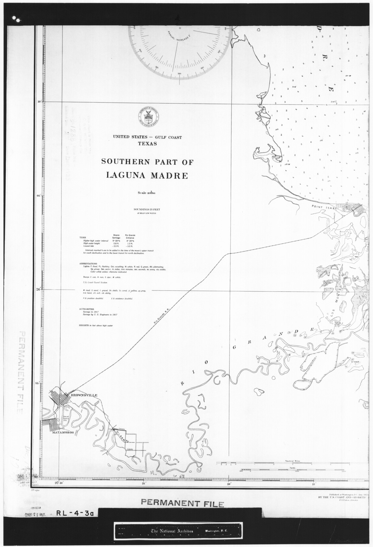
United States - Gulf Coast Texas - Southern part of Laguna Madre
RL-4-3a
-
Map/Doc
72949
-
Collection
General Map Collection
-
Object Dates
1933 (Creation Date)
-
People and Organizations
U. S. Coast and Geodetic Survey (Publisher)
U. S. Coast and Geodetic Survey (Author)
U. S. Engineers (Surveyor/Engineer)
-
Subjects
Nautical Charts
-
Height x Width
26.8 x 18.3 inches
68.1 x 46.5 cm
-
Comments
B/W photostat copy from National Archives in multiple pieces.
Part of: General Map Collection
San Saba County Sketch File 6

Print $6.00
- Digital $50.00
San Saba County Sketch File 6
1881
Size 10.9 x 8.4 inches
Map/Doc 36414
Lipscomb County Working Sketch 2

Print $20.00
- Digital $50.00
Lipscomb County Working Sketch 2
1959
Size 33.4 x 36.6 inches
Map/Doc 70578
Flight Mission No. CRC-5R, Frame 40, Chambers County

Print $20.00
- Digital $50.00
Flight Mission No. CRC-5R, Frame 40, Chambers County
1956
Size 18.6 x 22.4 inches
Map/Doc 84959
Sterling County Sketch File 10

Print $30.00
- Digital $50.00
Sterling County Sketch File 10
1927
Size 11.2 x 8.7 inches
Map/Doc 37133
Fort Bend County Sketch File 27

Print $20.00
- Digital $50.00
Fort Bend County Sketch File 27
1910
Size 17.9 x 37.7 inches
Map/Doc 10453
Falls County Sketch File 33

Print $4.00
- Digital $50.00
Falls County Sketch File 33
1873
Size 10.3 x 8.3 inches
Map/Doc 22441
Brewster County Rolled Sketch 60

Print $40.00
- Digital $50.00
Brewster County Rolled Sketch 60
Size 37.1 x 68.9 inches
Map/Doc 8485
[Sketch for Mineral Application 18874 - Pecos River Bed, W. J. Bonner]
![65584, [Sketch for Mineral Application 18874 - Pecos River Bed, W. J. Bonner], General Map Collection](https://historictexasmaps.com/wmedia_w700/maps/65584.tif.jpg)
Print $20.00
- Digital $50.00
[Sketch for Mineral Application 18874 - Pecos River Bed, W. J. Bonner]
1927
Size 37.5 x 31.6 inches
Map/Doc 65584
Chambers County Rolled Sketch 7

Print $20.00
- Digital $50.00
Chambers County Rolled Sketch 7
Size 39.8 x 23.1 inches
Map/Doc 8611
Young County Rolled Sketch 9

Print $20.00
- Digital $50.00
Young County Rolled Sketch 9
1921
Size 24.0 x 22.6 inches
Map/Doc 8297
Flight Mission No. DQO-7K, Frame 98, Galveston County

Print $20.00
- Digital $50.00
Flight Mission No. DQO-7K, Frame 98, Galveston County
1952
Size 18.8 x 22.4 inches
Map/Doc 85113
Karnes County Sketch File 7a

Print $4.00
- Digital $50.00
Karnes County Sketch File 7a
1873
Size 10.1 x 8.1 inches
Map/Doc 28563
You may also like
Cherokee County Sketch File 7

Print $4.00
- Digital $50.00
Cherokee County Sketch File 7
Size 10.3 x 8.3 inches
Map/Doc 18128
Walker County Working Sketch Graphic Index

Print $20.00
- Digital $50.00
Walker County Working Sketch Graphic Index
1944
Size 43.3 x 36.8 inches
Map/Doc 76729
A new & correct map of Texas compiled from the most recent surveys & authorities to the year 1845

Print $20.00
- Digital $50.00
A new & correct map of Texas compiled from the most recent surveys & authorities to the year 1845
1845
Size 22.4 x 28.5 inches
Map/Doc 96973
Duval County Working Sketch 16

Print $20.00
- Digital $50.00
Duval County Working Sketch 16
1939
Size 14.6 x 25.3 inches
Map/Doc 68729
[Town Plat of Galveston]
![76258, [Town Plat of Galveston], Texas State Library and Archives](https://historictexasmaps.com/wmedia_w700/maps/76258.tif.jpg)
Print $20.00
[Town Plat of Galveston]
1877
Size 9.1 x 14.5 inches
Map/Doc 76258
[Right of Way and Track Map, the Missouri, Kansas and Texas Ry. of Texas - Henrietta Division]
![64766, [Right of Way and Track Map, the Missouri, Kansas and Texas Ry. of Texas - Henrietta Division], General Map Collection](https://historictexasmaps.com/wmedia_w700/maps/64766.tif.jpg)
Print $20.00
- Digital $50.00
[Right of Way and Track Map, the Missouri, Kansas and Texas Ry. of Texas - Henrietta Division]
1918
Size 11.8 x 26.9 inches
Map/Doc 64766
Terrell County Rolled Sketch 14

Print $40.00
- Digital $50.00
Terrell County Rolled Sketch 14
Size 52.6 x 16.0 inches
Map/Doc 10309
Comanche County Boundary File 2a

Print $4.00
- Digital $50.00
Comanche County Boundary File 2a
Size 14.3 x 8.8 inches
Map/Doc 51788
Goliad Station Map, Galveston, Harrisburg & San Antonio Ry. operated by the T. & N. O. R.R. Co.

Print $40.00
- Digital $50.00
Goliad Station Map, Galveston, Harrisburg & San Antonio Ry. operated by the T. & N. O. R.R. Co.
1918
Size 24.7 x 55.8 inches
Map/Doc 76161
Water-Shed of the Pease River Drainage Area

Print $6.00
- Digital $50.00
Water-Shed of the Pease River Drainage Area
Size 14.9 x 31.0 inches
Map/Doc 65102
Haskell County

Print $20.00
- Digital $50.00
Haskell County
1873
Size 21.0 x 25.2 inches
Map/Doc 3643
[Area to the West and North of the Abraham Winfrey survey 11]
![90228, [Area to the West and North of the Abraham Winfrey survey 11], Twichell Survey Records](https://historictexasmaps.com/wmedia_w700/maps/90228-1.tif.jpg)
Print $20.00
- Digital $50.00
[Area to the West and North of the Abraham Winfrey survey 11]
1920
Size 23.2 x 24.1 inches
Map/Doc 90228