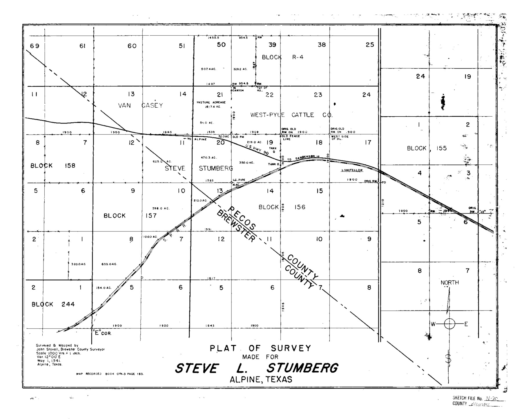
Brewster County Sketch File N-20
Plat of survey made for Steve L. Stumberg [showing surveys in parts of Blocks 155, 156, and 157]
-
Map/Doc
10967
-
Collection
General Map Collection
-
Object Dates
1941/5/1 (Creation Date)
-
People and Organizations
John Stovell (Surveyor/Engineer)
-
Counties
Brewster Pecos
-
Subjects
Surveying Sketch File
-
Height x Width
16.5 x 20.5 inches
41.9 x 52.1 cm
-
Medium
blueprint/diazo
-
Scale
1" = 1000 varas
-
Features
U.S. Highway 90 to Sanderson
U.S. Highway 90
Sanderson Road
Southern Pacific Railroad Company
Part of: General Map Collection
Hemphill County Sketch File 5

Print $8.00
- Digital $50.00
Hemphill County Sketch File 5
1903
Size 11.2 x 8.8 inches
Map/Doc 26295
Flight Mission No. CUG-1P, Frame 106, Kleberg County

Print $20.00
- Digital $50.00
Flight Mission No. CUG-1P, Frame 106, Kleberg County
1956
Size 18.8 x 22.3 inches
Map/Doc 86156
Dallas County Sketch File 5

Print $18.00
- Digital $50.00
Dallas County Sketch File 5
1858
Size 10.5 x 8.4 inches
Map/Doc 20400
Bosque County Sketch File 23

Print $6.00
- Digital $50.00
Bosque County Sketch File 23
1863
Size 10.2 x 8.2 inches
Map/Doc 14806
Flight Mission No. DQO-3K, Frame 37, Galveston County

Print $20.00
- Digital $50.00
Flight Mission No. DQO-3K, Frame 37, Galveston County
1952
Size 18.7 x 22.6 inches
Map/Doc 85078
Flight Mission No. DAH-9M, Frame 198, Orange County

Print $20.00
- Digital $50.00
Flight Mission No. DAH-9M, Frame 198, Orange County
1953
Size 18.6 x 22.5 inches
Map/Doc 86866
Duval County Rolled Sketch HD

Print $20.00
- Digital $50.00
Duval County Rolled Sketch HD
1939
Size 22.8 x 32.8 inches
Map/Doc 5767
Nueces County Rolled Sketch 96

Print $44.00
Nueces County Rolled Sketch 96
1983
Size 24.2 x 36.5 inches
Map/Doc 7053
Henderson County Working Sketch 12

Print $20.00
- Digital $50.00
Henderson County Working Sketch 12
1915
Size 23.3 x 24.9 inches
Map/Doc 66145
Flight Mission No. BRA-8M, Frame 149, Jefferson County

Print $20.00
- Digital $50.00
Flight Mission No. BRA-8M, Frame 149, Jefferson County
1953
Size 18.8 x 22.4 inches
Map/Doc 85641
DeWitt County Working Sketch 6

Print $20.00
- Digital $50.00
DeWitt County Working Sketch 6
1977
Size 30.6 x 26.6 inches
Map/Doc 68596
Hardin County Sketch File 3a

Print $12.00
- Digital $50.00
Hardin County Sketch File 3a
1858
Size 10.0 x 7.9 inches
Map/Doc 25088
You may also like
Lynn County Boundary File 7

Print $10.00
- Digital $50.00
Lynn County Boundary File 7
Size 11.5 x 8.8 inches
Map/Doc 56642
Blanco County Boundary File 10

Print $26.00
- Digital $50.00
Blanco County Boundary File 10
Size 8.9 x 7.6 inches
Map/Doc 50576
Concho County Sketch File 26

Print $6.00
- Digital $50.00
Concho County Sketch File 26
1885
Size 11.5 x 9.0 inches
Map/Doc 19159
Hidalgo County Sketch File 12

Print $20.00
- Digital $50.00
Hidalgo County Sketch File 12
Size 16.3 x 25.1 inches
Map/Doc 11763
From Citizens of Shelby County for the Creation of a New County to be Called Caddo, April 7, 1838

Print $20.00
From Citizens of Shelby County for the Creation of a New County to be Called Caddo, April 7, 1838
2020
Size 25.5 x 21.7 inches
Map/Doc 96377
Jackson County Boundary File 1

Print $24.00
- Digital $50.00
Jackson County Boundary File 1
Size 9.0 x 3.9 inches
Map/Doc 55420
Hudspeth County Sketch File 19

Print $4.00
- Digital $50.00
Hudspeth County Sketch File 19
1901
Size 11.3 x 8.8 inches
Map/Doc 26962
Bandera County Working Sketch 39

Print $20.00
- Digital $50.00
Bandera County Working Sketch 39
1975
Size 22.1 x 25.3 inches
Map/Doc 67635
Flight Mission No. BRA-16M, Frame 50, Jefferson County

Print $20.00
- Digital $50.00
Flight Mission No. BRA-16M, Frame 50, Jefferson County
1953
Size 18.5 x 22.5 inches
Map/Doc 85667
Culberson County Rolled Sketch 46

Print $40.00
- Digital $50.00
Culberson County Rolled Sketch 46
1953
Size 53.1 x 43.1 inches
Map/Doc 8754
Irion County Boundary File 1

Print $36.00
- Digital $50.00
Irion County Boundary File 1
Size 8.9 x 4.1 inches
Map/Doc 55316
Parker County Sketch File D

Print $4.00
- Digital $50.00
Parker County Sketch File D
Size 9.9 x 8.2 inches
Map/Doc 33514