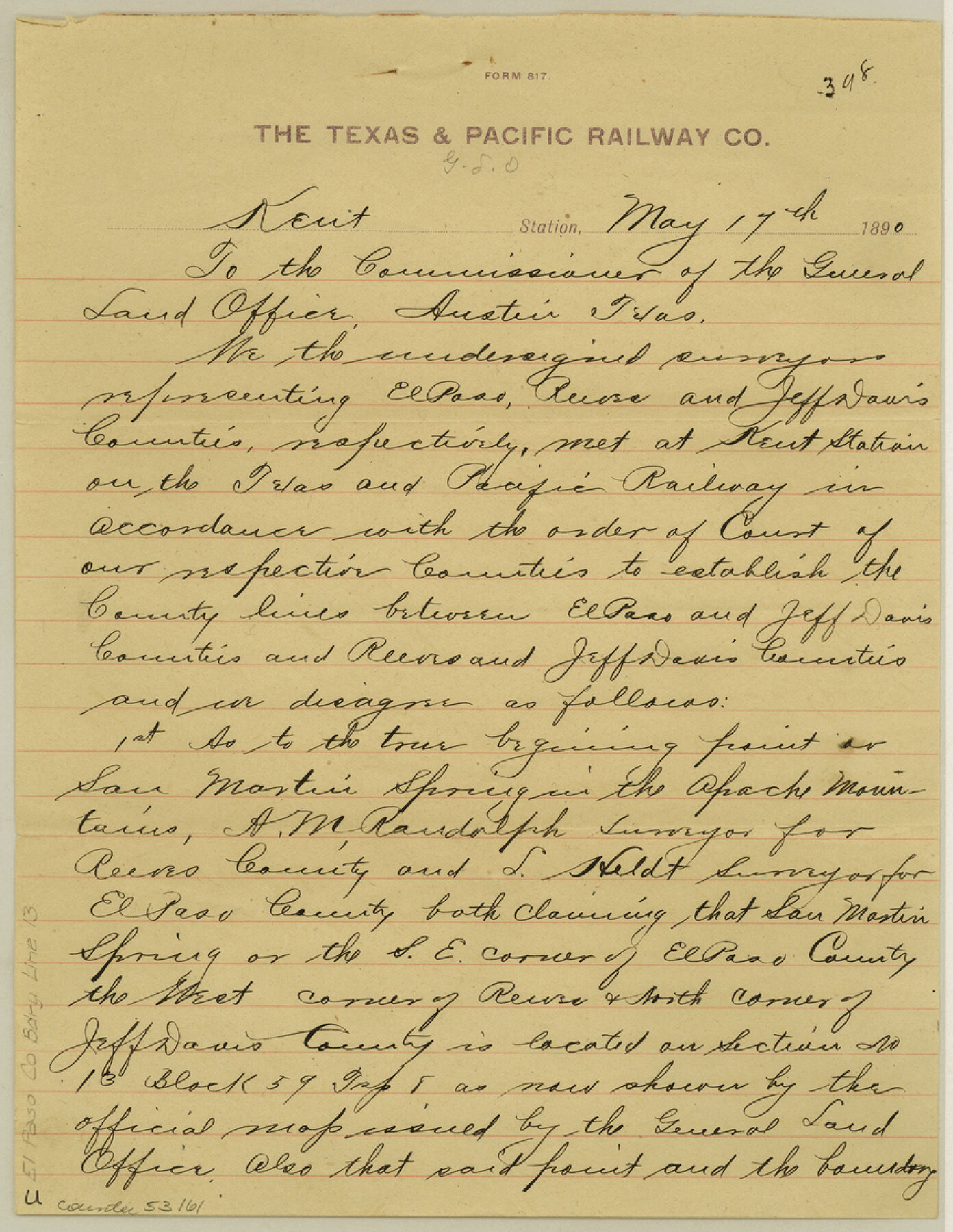
El Paso County Boundary File 13
Disagreement as to the true San Martin Springs by the Surveyors of El Paso and Reeves
-
Map/Doc
53161
-
Collection
General Map Collection
-
Counties
El Paso
-
Subjects
County Boundaries
-
Height x Width
11.1 x 8.6 inches
28.2 x 21.8 cm
Part of: General Map Collection
FT. W. & R. G. Ry. Right of Way Map, Whiteland to Lightner, Concho County, Texas

Print $40.00
- Digital $50.00
FT. W. & R. G. Ry. Right of Way Map, Whiteland to Lightner, Concho County, Texas
1918
Size 39.6 x 121.3 inches
Map/Doc 61412
Webb County Rolled Sketch 47

Print $20.00
- Digital $50.00
Webb County Rolled Sketch 47
Size 23.5 x 31.7 inches
Map/Doc 8203
Map of a part of Laguna Madre showing subdivision for mineral development

Print $20.00
- Digital $50.00
Map of a part of Laguna Madre showing subdivision for mineral development
1948
Size 42.9 x 31.0 inches
Map/Doc 2913
Flight Mission No. CGI-3N, Frame 131, Cameron County

Print $20.00
- Digital $50.00
Flight Mission No. CGI-3N, Frame 131, Cameron County
1954
Size 18.7 x 22.3 inches
Map/Doc 84604
McMullen County Working Sketch 29

Print $40.00
- Digital $50.00
McMullen County Working Sketch 29
1956
Size 59.0 x 37.2 inches
Map/Doc 70730
Midland County Working Sketch 19

Print $20.00
- Digital $50.00
Midland County Working Sketch 19
1953
Size 29.9 x 24.7 inches
Map/Doc 70999
Current Miscellaneous File 33

Print $6.00
- Digital $50.00
Current Miscellaneous File 33
1953
Size 10.8 x 8.2 inches
Map/Doc 73939
Flight Mission No. BQR-7K, Frame 25, Brazoria County

Print $20.00
- Digital $50.00
Flight Mission No. BQR-7K, Frame 25, Brazoria County
1952
Size 18.8 x 22.3 inches
Map/Doc 84023
La Salle County Working Sketch 8

Print $20.00
- Digital $50.00
La Salle County Working Sketch 8
1922
Size 19.0 x 18.3 inches
Map/Doc 70309
Nueces County Rolled Sketch 113B

Print $20.00
- Digital $50.00
Nueces County Rolled Sketch 113B
1972
Size 18.6 x 24.2 inches
Map/Doc 7123
Flight Mission No. DAG-21K, Frame 28, Matagorda County

Print $20.00
- Digital $50.00
Flight Mission No. DAG-21K, Frame 28, Matagorda County
1952
Size 18.6 x 22.4 inches
Map/Doc 86395
San Jacinto County Working Sketch 12

Print $20.00
- Digital $50.00
San Jacinto County Working Sketch 12
1935
Size 33.4 x 37.3 inches
Map/Doc 63725
You may also like
Map of Wood County, Texas

Print $20.00
- Digital $50.00
Map of Wood County, Texas
1879
Size 17.5 x 17.1 inches
Map/Doc 659
Jefferson County Rolled Sketch 60

Print $20.00
- Digital $50.00
Jefferson County Rolled Sketch 60
1885
Size 31.0 x 35.6 inches
Map/Doc 9315
From Citizens Living in Washington County for the Creation of a New County to be Called Washington, Undated

Print $20.00
From Citizens Living in Washington County for the Creation of a New County to be Called Washington, Undated
2020
Size 17.0 x 21.7 inches
Map/Doc 96406
[Maps of surveys in Reeves & Culberson Cos]
![61146, [Maps of surveys in Reeves & Culberson Cos], General Map Collection](https://historictexasmaps.com/wmedia_w700/maps/61146.tif.jpg)
Print $20.00
- Digital $50.00
[Maps of surveys in Reeves & Culberson Cos]
1937
Size 30.8 x 24.9 inches
Map/Doc 61146
Foard County Rolled Sketch 16

Print $40.00
- Digital $50.00
Foard County Rolled Sketch 16
1889
Size 36.9 x 72.8 inches
Map/Doc 8893
Anderson County Rolled Sketch 10

Print $20.00
- Digital $50.00
Anderson County Rolled Sketch 10
1956
Size 33.4 x 34.6 inches
Map/Doc 8365
Map of Harris District

Print $20.00
- Digital $50.00
Map of Harris District
1847
Size 25.4 x 34.4 inches
Map/Doc 1680
Bowie County Sketch File A

Print $40.00
- Digital $50.00
Bowie County Sketch File A
1902
Size 15.6 x 27.3 inches
Map/Doc 10946
Harbor Pass and Bar at Brazos Santiago, Texas

Print $20.00
- Digital $50.00
Harbor Pass and Bar at Brazos Santiago, Texas
1871
Size 18.2 x 27.0 inches
Map/Doc 73037
Fort Bend County Working Sketch 14

Print $20.00
- Digital $50.00
Fort Bend County Working Sketch 14
1948
Size 37.4 x 32.7 inches
Map/Doc 69220
Map of Fayette County

Print $20.00
- Digital $50.00
Map of Fayette County
1843
Size 21.9 x 26.7 inches
Map/Doc 3537
Jasper County Rolled Sketch 4

Print $20.00
- Digital $50.00
Jasper County Rolled Sketch 4
1947
Size 40.0 x 31.1 inches
Map/Doc 6351