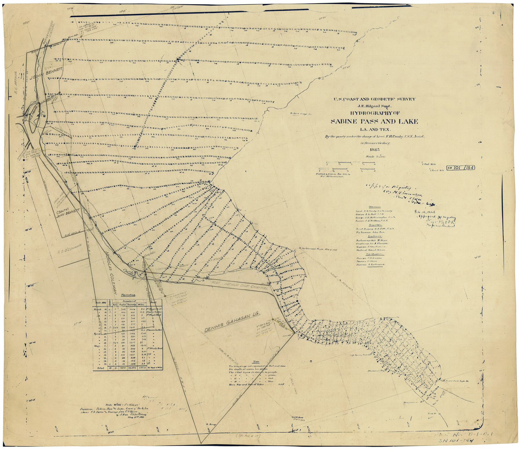
Jefferson County Rolled Sketch 60
Hydrography of Sabine Pass and Lake, LA. and TEX.
-
Map/Doc
9315
-
Collection
General Map Collection
-
Object Dates
1885 (Creation Date)
2/11/1976 (File Date)
-
Counties
Jefferson
-
Subjects
Surveying Rolled Sketch
-
Height x Width
31.0 x 35.6 inches
78.7 x 90.4 cm
-
Medium
blueprint/diazo
-
Comments
For north part of map, see Jefferson County Rolled Sketch 60 (9316).
Related maps
Jefferson County Rolled Sketch 60

Print $20.00
- Digital $50.00
Jefferson County Rolled Sketch 60
1885
Size 34.0 x 35.9 inches
Map/Doc 9316
Part of: General Map Collection
Hale County Boundary File 2

Print $4.00
- Digital $50.00
Hale County Boundary File 2
Size 10.9 x 8.8 inches
Map/Doc 54044
Rusk County Working Sketch 8

Print $20.00
- Digital $50.00
Rusk County Working Sketch 8
1981
Size 22.4 x 20.6 inches
Map/Doc 63643
Brazos County Sketch File 5

Print $34.00
- Digital $50.00
Brazos County Sketch File 5
1935
Size 8.2 x 7.1 inches
Map/Doc 15559
Mason County Rolled Sketch 1

Print $20.00
- Digital $50.00
Mason County Rolled Sketch 1
1940
Size 21.2 x 24.9 inches
Map/Doc 6674
Map of Wood County

Print $20.00
- Digital $50.00
Map of Wood County
1857
Size 22.5 x 29.1 inches
Map/Doc 4165
Flight Mission No. DAH-17M, Frame 61, Orange County

Print $20.00
- Digital $50.00
Flight Mission No. DAH-17M, Frame 61, Orange County
1953
Size 18.6 x 22.5 inches
Map/Doc 86895
Kleberg County Rolled Sketch 6

Print $20.00
- Digital $50.00
Kleberg County Rolled Sketch 6
Size 11.1 x 13.0 inches
Map/Doc 9359
Bell County Working Sketch 4

Print $20.00
- Digital $50.00
Bell County Working Sketch 4
1942
Size 26.9 x 21.0 inches
Map/Doc 67344
Collingsworth County Working Sketch 2

Print $20.00
- Digital $50.00
Collingsworth County Working Sketch 2
1957
Size 42.5 x 20.1 inches
Map/Doc 63761
[Map of Upshur County]
![[Map of Upshur County]](https://historictexasmaps.com/wmedia_w700/maps/4651.tif.jpg)
Print $20.00
- Digital $50.00
[Map of Upshur County]
1850
Size 25.2 x 17.8 inches
Map/Doc 4651
Frio County Working Sketch 26

Print $20.00
- Digital $50.00
Frio County Working Sketch 26
2001
Size 38.0 x 42.7 inches
Map/Doc 69300
Flight Mission No. BRA-7M, Frame 133, Jefferson County

Print $20.00
- Digital $50.00
Flight Mission No. BRA-7M, Frame 133, Jefferson County
1953
Size 18.6 x 22.3 inches
Map/Doc 85527
You may also like
From Citizens of Montgomery County to Redefine the Boundary Between Harris and Montgomery Counties, May 8, 1838

Print $20.00
From Citizens of Montgomery County to Redefine the Boundary Between Harris and Montgomery Counties, May 8, 1838
2020
Size 15.4 x 21.7 inches
Map/Doc 96382
Menard County Boundary File 3

Print $4.00
- Digital $50.00
Menard County Boundary File 3
Size 10.6 x 8.0 inches
Map/Doc 57072
Houston County Sketch File 29

Print $10.00
- Digital $50.00
Houston County Sketch File 29
1859
Size 15.0 x 9.4 inches
Map/Doc 26802
Liberty County Rolled Sketch I

Print $20.00
- Digital $50.00
Liberty County Rolled Sketch I
1944
Size 38.1 x 38.1 inches
Map/Doc 10642
Palo Pinto County Working Sketch 20

Print $20.00
- Digital $50.00
Palo Pinto County Working Sketch 20
1977
Size 30.2 x 38.1 inches
Map/Doc 71403
Map of Menard County

Print $20.00
- Digital $50.00
Map of Menard County
1871
Size 18.5 x 23.3 inches
Map/Doc 3872
Winkler County Working Sketch 3

Print $40.00
- Digital $50.00
Winkler County Working Sketch 3
1944
Size 43.5 x 60.5 inches
Map/Doc 72597
Map of Comal County

Print $20.00
- Digital $50.00
Map of Comal County
1862
Size 18.6 x 22.0 inches
Map/Doc 3429
Hudspeth County Rolled Sketch 38

Print $20.00
- Digital $50.00
Hudspeth County Rolled Sketch 38
1939
Size 18.0 x 37.5 inches
Map/Doc 6251
Jack County Working Sketch 23

Print $20.00
- Digital $50.00
Jack County Working Sketch 23
2006
Size 18.4 x 22.0 inches
Map/Doc 83606
Flight Mission No. DQN-2K, Frame 87, Calhoun County

Print $20.00
- Digital $50.00
Flight Mission No. DQN-2K, Frame 87, Calhoun County
1953
Size 18.9 x 22.6 inches
Map/Doc 84277
Haskell County Working Sketch 15

Print $40.00
- Digital $50.00
Haskell County Working Sketch 15
1983
Size 48.0 x 57.5 inches
Map/Doc 66073