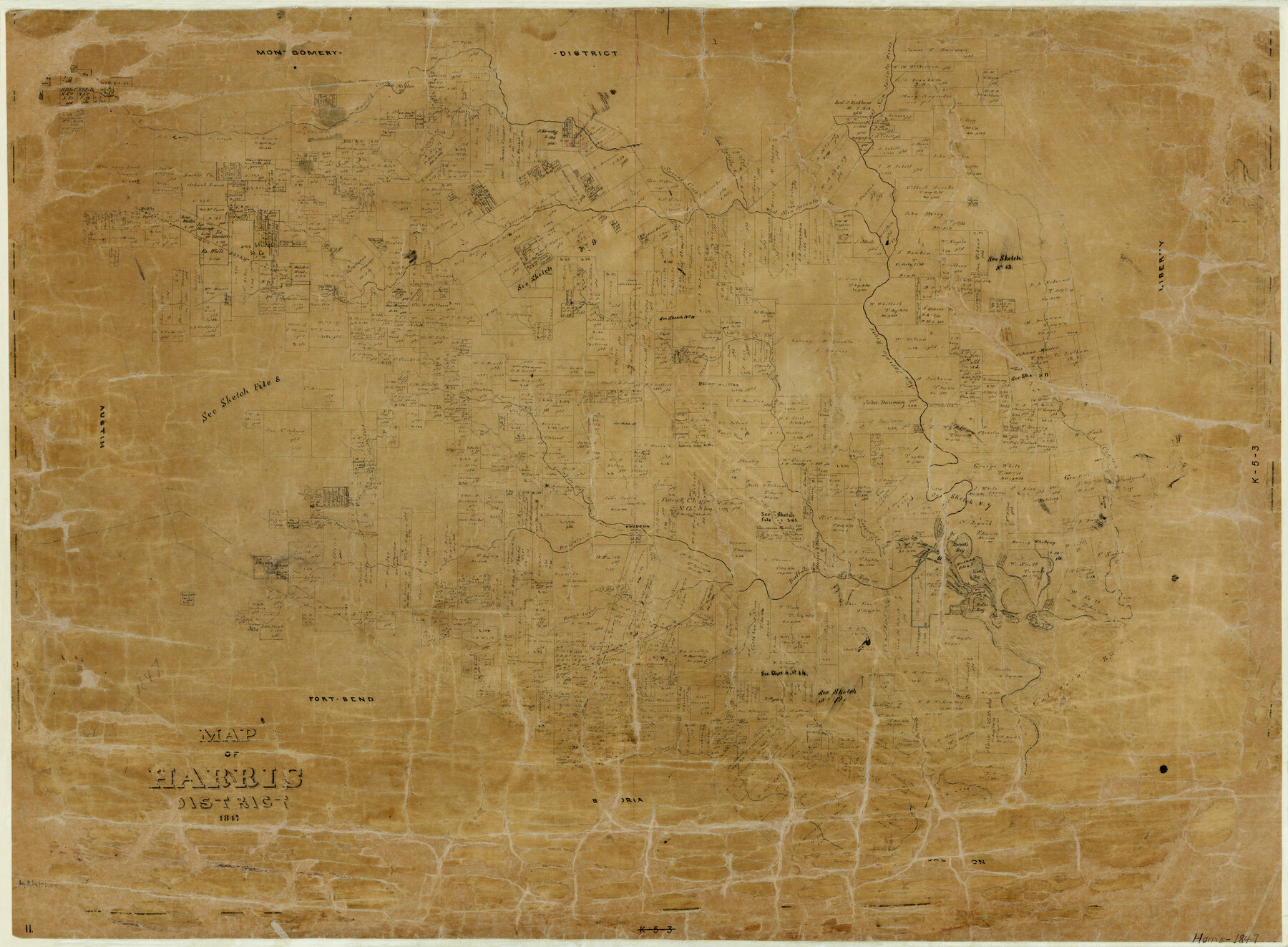
Map of Harris District
K-5-3
-
Map/Doc
1680
-
Collection
General Map Collection
-
Object Dates
1847 (Creation Date)
-
Counties
Harris
-
Subjects
County
-
Height x Width
25.4 x 34.4 inches
64.5 x 87.4 cm
-
Features
Sims Bayou
San Jacinto Battleground
San Jacinto
Carpenters Bayou
Buffalo Bayou
Hunting Bayou
Houston
White Oak Bayou
Bray's Bayou
Spring Bayou
Clear Creek
Old Red Bay
Middle Creek
Clair Creek
Galveston Bay
Clear Lake
Junction
East San Jacinto River
Hockley
Turkey Creek
Lynchburg
Green's Bayou
Willow Creek
San Jacinto River
Luce Bayou
West San Jacinto River
Cypress Bayou
H&C
Hockley Depot
Horse Pen Bayou
North Fork of Horse Pen Bayou
South Fork of Green's Bayou
Spring Creek
Cedar Bayou
Hog Island
Ruth's Bay
Scott's Bay
Burnet's Bay
William Perkin's Island
McCormick's Bay
Luce Channel
Buffalo Bay
Part of: General Map Collection
Bowie County Sketch File 8f

Print $10.00
- Digital $50.00
Bowie County Sketch File 8f
1928
Size 8.1 x 5.2 inches
Map/Doc 14902
2008 Official Travel Map, Texas

2008 Official Travel Map, Texas
Size 33.4 x 36.5 inches
Map/Doc 94343
Dallas/Fort Worth Street Map & Visitor Guide

Dallas/Fort Worth Street Map & Visitor Guide
2000
Size 35.5 x 23.1 inches
Map/Doc 94296
Brazoria County Working Sketch 11

Print $20.00
- Digital $50.00
Brazoria County Working Sketch 11
1935
Size 18.1 x 24.3 inches
Map/Doc 67496
Flight Mission No. CRE-2R, Frame 158, Jackson County

Print $20.00
- Digital $50.00
Flight Mission No. CRE-2R, Frame 158, Jackson County
1956
Size 16.1 x 16.1 inches
Map/Doc 85369
Grimes County Rolled Sketch 1

Print $20.00
- Digital $50.00
Grimes County Rolled Sketch 1
1945
Size 34.6 x 35.0 inches
Map/Doc 9007
Chambers County Sketch File 32

Print $8.00
- Digital $50.00
Chambers County Sketch File 32
1900
Size 7.1 x 10.6 inches
Map/Doc 17616
Cherokee County Working Sketch 19

Print $40.00
- Digital $50.00
Cherokee County Working Sketch 19
1967
Size 64.1 x 49.2 inches
Map/Doc 67974
[Surveys in Austin's Colony along the east bank of the Navidad River]
![211, [Surveys in Austin's Colony along the east bank of the Navidad River], General Map Collection](https://historictexasmaps.com/wmedia_w700/maps/211.tif.jpg)
Print $20.00
- Digital $50.00
[Surveys in Austin's Colony along the east bank of the Navidad River]
1827
Size 20.2 x 16.1 inches
Map/Doc 211
![78444, [Webb County], General Map Collection](https://historictexasmaps.com/wmedia_w700/maps/78444.tif.jpg)
Montgomery County Sketch File 11

Print $4.00
- Digital $50.00
Montgomery County Sketch File 11
1872
Size 6.7 x 7.9 inches
Map/Doc 31800
Bell County Sketch File 19

Print $4.00
- Digital $50.00
Bell County Sketch File 19
Size 7.6 x 7.7 inches
Map/Doc 14402
You may also like
Comanche County Sketch File 1

Print $6.00
- Digital $50.00
Comanche County Sketch File 1
1847
Size 15.4 x 11.8 inches
Map/Doc 19051
Duval County Sketch File 32b

Print $6.00
- Digital $50.00
Duval County Sketch File 32b
Size 14.2 x 8.9 inches
Map/Doc 21339
Polk County Working Sketch 9

Print $20.00
- Digital $50.00
Polk County Working Sketch 9
1934
Size 22.7 x 30.8 inches
Map/Doc 71624
[A. B. & M. Block 2]
![91794, [A. B. & M. Block 2], Twichell Survey Records](https://historictexasmaps.com/wmedia_w700/maps/91794-1.tif.jpg)
Print $2.00
- Digital $50.00
[A. B. & M. Block 2]
Size 7.1 x 14.1 inches
Map/Doc 91794
[Surveys Surrounding I. G. Yates S.F. 12394]
![91577, [Surveys Surrounding I. G. Yates S.F. 12394], Twichell Survey Records](https://historictexasmaps.com/wmedia_w700/maps/91577-1.tif.jpg)
Print $20.00
- Digital $50.00
[Surveys Surrounding I. G. Yates S.F. 12394]
Size 18.6 x 7.2 inches
Map/Doc 91577
Edwards County Working Sketch 15

Print $20.00
- Digital $50.00
Edwards County Working Sketch 15
1927
Size 30.0 x 28.4 inches
Map/Doc 68891
[Scurry and Zavala County School Lands, and Blocks X, D, K, D-14, D-11, and E]
![91201, [Scurry and Zavala County School Lands, and Blocks X, D, K, D-14, D-11, and E], Twichell Survey Records](https://historictexasmaps.com/wmedia_w700/maps/91201-1.tif.jpg)
Print $20.00
- Digital $50.00
[Scurry and Zavala County School Lands, and Blocks X, D, K, D-14, D-11, and E]
Size 43.7 x 37.2 inches
Map/Doc 91201
Sketch, Val Verde County, Part of Blk. D-7 E. L. & R. R. Ry., Survey for Mrs. Geo. Baker, P. Bradford et. al.

Print $20.00
- Digital $50.00
Sketch, Val Verde County, Part of Blk. D-7 E. L. & R. R. Ry., Survey for Mrs. Geo. Baker, P. Bradford et. al.
1937
Size 18.2 x 16.2 inches
Map/Doc 91873
Current Miscellaneous File 115

Print $16.00
- Digital $50.00
Current Miscellaneous File 115
1950
Size 11.3 x 8.8 inches
Map/Doc 74811
Tom Green County Working Sketch 13

Print $20.00
- Digital $50.00
Tom Green County Working Sketch 13
1981
Size 34.3 x 26.4 inches
Map/Doc 69382
Hardin County Sketch File 53

Print $12.00
- Digital $50.00
Hardin County Sketch File 53
Size 11.4 x 8.8 inches
Map/Doc 25213
[Leagues 571- 575, 578- 583, 603- 609, and Surrounding Surveys]
![91065, [Leagues 571- 575, 578- 583, 603- 609, and Surrounding Surveys], Twichell Survey Records](https://historictexasmaps.com/wmedia_w700/maps/91065-1.tif.jpg)
Print $20.00
- Digital $50.00
[Leagues 571- 575, 578- 583, 603- 609, and Surrounding Surveys]
Size 43.2 x 12.5 inches
Map/Doc 91065