Nueces County Rolled Sketch 113B
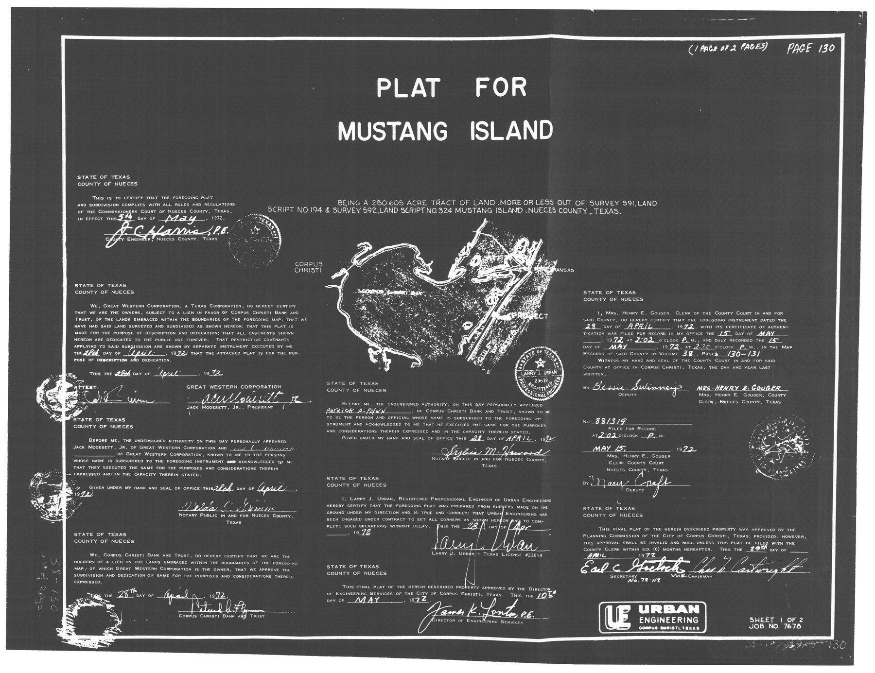
Plat for Mustang Island being a 280.605 acre tract of land more or less out of survey 591, land script no. 194 & survey 592, land script no. 324, Mustang Island, Nueces County, Texas
-
Map/Doc
7123
-
Collection
General Map Collection
-
Object Dates
4/28/1972 (Creation Date)
11/7/1991 (File Date)
-
People and Organizations
Larry J. Urban (Surveyor/Engineer)
-
Counties
Nueces
-
Subjects
Surveying Rolled Sketch
-
Height x Width
18.6 x 24.2 inches
47.2 x 61.5 cm
-
Medium
photostat
-
Comments
Sheet 1 of 2. See Nueces County Rolled Sketch 113B (7124) for sheet 2. Filed for information only.
Related maps
Nueces County Rolled Sketch 113B

Print $20.00
- Digital $50.00
Nueces County Rolled Sketch 113B
1972
Size 18.3 x 23.6 inches
Map/Doc 7124
Part of: General Map Collection
Caddo Lake and Subdivision

Print $20.00
- Digital $50.00
Caddo Lake and Subdivision
1918
Size 35.0 x 29.8 inches
Map/Doc 93283
Chambers County Sketch File 58

Print $2.00
- Digital $50.00
Chambers County Sketch File 58
1995
Size 9.1 x 14.7 inches
Map/Doc 18108
Map of Wichita Co.

Print $20.00
- Digital $50.00
Map of Wichita Co.
1897
Size 29.7 x 36.7 inches
Map/Doc 16925
Leon County Working Sketch 42

Print $40.00
- Digital $50.00
Leon County Working Sketch 42
1980
Size 56.8 x 42.8 inches
Map/Doc 70441
Wharton County

Print $20.00
- Digital $50.00
Wharton County
1877
Size 24.6 x 26.7 inches
Map/Doc 4133
Pecos County Rolled Sketch 142

Print $20.00
- Digital $50.00
Pecos County Rolled Sketch 142
Size 26.9 x 41.9 inches
Map/Doc 7276
Zavala County Working Sketch 18

Print $20.00
- Digital $50.00
Zavala County Working Sketch 18
1977
Size 43.8 x 42.1 inches
Map/Doc 62093
Map of Ellis County

Print $40.00
- Digital $50.00
Map of Ellis County
1889
Size 39.2 x 48.1 inches
Map/Doc 4712
Harrison County Sketch File 19

Print $20.00
- Digital $50.00
Harrison County Sketch File 19
1954
Size 25.0 x 21.7 inches
Map/Doc 11692
Nolan County Sketch File 5

Print $40.00
- Digital $50.00
Nolan County Sketch File 5
Size 51.0 x 44.0 inches
Map/Doc 10558
[Surveys in Polk and Chambers Counties]
![355, [Surveys in Polk and Chambers Counties], General Map Collection](https://historictexasmaps.com/wmedia_w700/maps/355.tif.jpg)
Print $3.00
- Digital $50.00
[Surveys in Polk and Chambers Counties]
Size 11.7 x 14.4 inches
Map/Doc 355
Travis County Appraisal District Plat Map 1_0005

Print $20.00
- Digital $50.00
Travis County Appraisal District Plat Map 1_0005
Size 21.5 x 26.4 inches
Map/Doc 94204
You may also like
Map of Bowie County

Print $20.00
- Digital $50.00
Map of Bowie County
1862
Size 20.0 x 23.5 inches
Map/Doc 3317
General Highway Map, Wharton County, Texas

Print $20.00
General Highway Map, Wharton County, Texas
1961
Size 18.3 x 24.7 inches
Map/Doc 79706
Midland County Rolled Sketch 9

Print $40.00
- Digital $50.00
Midland County Rolled Sketch 9
Size 73.4 x 17.3 inches
Map/Doc 6766
Map of north end of Brazos Island

Print $20.00
- Digital $50.00
Map of north end of Brazos Island
Size 27.7 x 18.3 inches
Map/Doc 72907
Intracoastal Waterway in Texas - Corpus Christi to Point Isabel including Arroyo Colorado to Mo. Pac. R.R. Bridge Near Harlingen

Print $20.00
- Digital $50.00
Intracoastal Waterway in Texas - Corpus Christi to Point Isabel including Arroyo Colorado to Mo. Pac. R.R. Bridge Near Harlingen
1934
Size 21.8 x 32.7 inches
Map/Doc 61885
Red River County Working Sketch 8

Print $20.00
- Digital $50.00
Red River County Working Sketch 8
1920
Size 16.2 x 14.2 inches
Map/Doc 71991
Crockett County Rolled Sketch 81

Print $20.00
- Digital $50.00
Crockett County Rolled Sketch 81
1958
Size 20.6 x 24.5 inches
Map/Doc 5621
Dimmit County Sketch File 62

Print $8.00
- Digital $50.00
Dimmit County Sketch File 62
2012
Size 11.0 x 8.5 inches
Map/Doc 93631
Travis County Rolled Sketch 8

Print $20.00
- Digital $50.00
Travis County Rolled Sketch 8
1928
Size 30.9 x 24.2 inches
Map/Doc 8013
Brazoria County Sketch File 7

Print $4.00
- Digital $50.00
Brazoria County Sketch File 7
1868
Size 8.6 x 11.0 inches
Map/Doc 14932
Hunt County Sketch File 34a

Print $4.00
- Digital $50.00
Hunt County Sketch File 34a
1873
Size 8.0 x 10.1 inches
Map/Doc 27146
Hudspeth County Rolled Sketch 66

Print $20.00
- Digital $50.00
Hudspeth County Rolled Sketch 66
1973
Size 11.9 x 20.5 inches
Map/Doc 6259