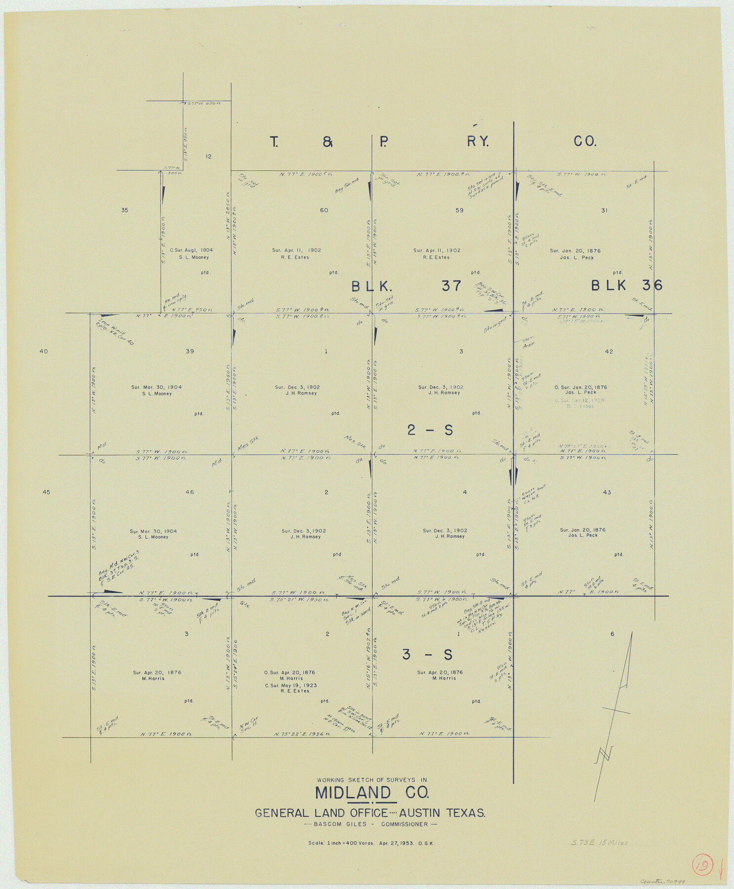
Midland County Working Sketch 19
-
Map/Doc
70999
-
Collection
General Map Collection
-
Object Dates
4/27/1953 (Creation Date)
-
People and Organizations
Otto G. Kurio (Draftsman)
-
Counties
Midland
-
Subjects
Surveying Working Sketch
-
Height x Width
29.9 x 24.7 inches
76.0 x 62.7 cm
-
Scale
1" = 400 varas
Part of: General Map Collection
Hill County Working Sketch 1

Print $20.00
- Digital $50.00
Hill County Working Sketch 1
1939
Size 11.0 x 17.8 inches
Map/Doc 66187
Aransas County Rolled Sketch 12

Print $20.00
- Digital $50.00
Aransas County Rolled Sketch 12
Size 17.6 x 11.1 inches
Map/Doc 77191
North Sulphur River, Sims Crossing Sheet

Print $20.00
- Digital $50.00
North Sulphur River, Sims Crossing Sheet
1924
Size 23.4 x 39.9 inches
Map/Doc 65167
Harris County Working Sketch 36

Print $20.00
- Digital $50.00
Harris County Working Sketch 36
1938
Size 23.8 x 23.8 inches
Map/Doc 65928
[Texas & Pacific Railway through Callahan County]
![64232, [Texas & Pacific Railway through Callahan County], General Map Collection](https://historictexasmaps.com/wmedia_w700/maps/64232.tif.jpg)
Print $20.00
- Digital $50.00
[Texas & Pacific Railway through Callahan County]
1918
Size 20.8 x 9.4 inches
Map/Doc 64232
La Salle County Working Sketch 39

Print $20.00
- Digital $50.00
La Salle County Working Sketch 39
1963
Size 30.4 x 25.4 inches
Map/Doc 70340

Hopkins County Sketch File 1

Print $4.00
- Digital $50.00
Hopkins County Sketch File 1
1854
Size 5.2 x 10.2 inches
Map/Doc 26676
Flight Mission No. CRK-8P, Frame 101, Refugio County

Print $20.00
- Digital $50.00
Flight Mission No. CRK-8P, Frame 101, Refugio County
1956
Size 18.7 x 22.3 inches
Map/Doc 86962
Calhoun County Sketch File 12

Print $120.00
- Digital $50.00
Calhoun County Sketch File 12
Size 23.0 x 36.9 inches
Map/Doc 11033
Lamb County Sketch File 18

Print $4.00
- Digital $50.00
Lamb County Sketch File 18
1979
Size 14.3 x 8.9 inches
Map/Doc 29381
Henderson County Rolled Sketch 13

Print $20.00
- Digital $50.00
Henderson County Rolled Sketch 13
1987
Size 25.3 x 21.0 inches
Map/Doc 6205
You may also like
Duval County Rolled Sketch 41

Print $20.00
- Digital $50.00
Duval County Rolled Sketch 41
1966
Size 23.3 x 21.1 inches
Map/Doc 5758
Plat of Corpus Christi

Print $20.00
Plat of Corpus Christi
1850
Size 18.0 x 27.2 inches
Map/Doc 76269
Kerr County Sketch File 25

Print $4.00
- Digital $50.00
Kerr County Sketch File 25
1873
Size 10.0 x 8.0 inches
Map/Doc 28905
[Surveys in Waller County]
![78367, [Surveys in Waller County], General Map Collection](https://historictexasmaps.com/wmedia_w700/maps/78367.tif.jpg)
Print $20.00
- Digital $50.00
[Surveys in Waller County]
Size 21.5 x 28.7 inches
Map/Doc 78367
Old Miscellaneous File 18

Print $4.00
- Digital $50.00
Old Miscellaneous File 18
1913
Size 11.3 x 8.6 inches
Map/Doc 75497
[Beaumont, Sour Lake and Western Ry. Right of Way and Alignment - Frisco]
![64114, [Beaumont, Sour Lake and Western Ry. Right of Way and Alignment - Frisco], General Map Collection](https://historictexasmaps.com/wmedia_w700/maps/64114.tif.jpg)
Print $20.00
- Digital $50.00
[Beaumont, Sour Lake and Western Ry. Right of Way and Alignment - Frisco]
1910
Size 19.9 x 46.0 inches
Map/Doc 64114
Blanco County Working Sketch 12

Print $3.00
- Digital $50.00
Blanco County Working Sketch 12
1943
Size 11.9 x 10.9 inches
Map/Doc 67372
Guadalupe County Sketch File 15d

Print $4.00
- Digital $50.00
Guadalupe County Sketch File 15d
Size 10.1 x 8.1 inches
Map/Doc 24705
Working Sketch in Glasscock County

Print $3.00
- Digital $50.00
Working Sketch in Glasscock County
Size 9.8 x 9.8 inches
Map/Doc 90750
Presidio County Working Sketch Graphic Index, West Part, Sheet 1 (Sketches 1 to 74)

Print $20.00
- Digital $50.00
Presidio County Working Sketch Graphic Index, West Part, Sheet 1 (Sketches 1 to 74)
1974
Size 40.3 x 31.4 inches
Map/Doc 76672
Hutchinson County

Print $20.00
- Digital $50.00
Hutchinson County
1922
Size 45.6 x 38.8 inches
Map/Doc 1863
Hays County Rolled Sketch 20A

Print $20.00
- Digital $50.00
Hays County Rolled Sketch 20A
Size 20.7 x 23.9 inches
Map/Doc 6177