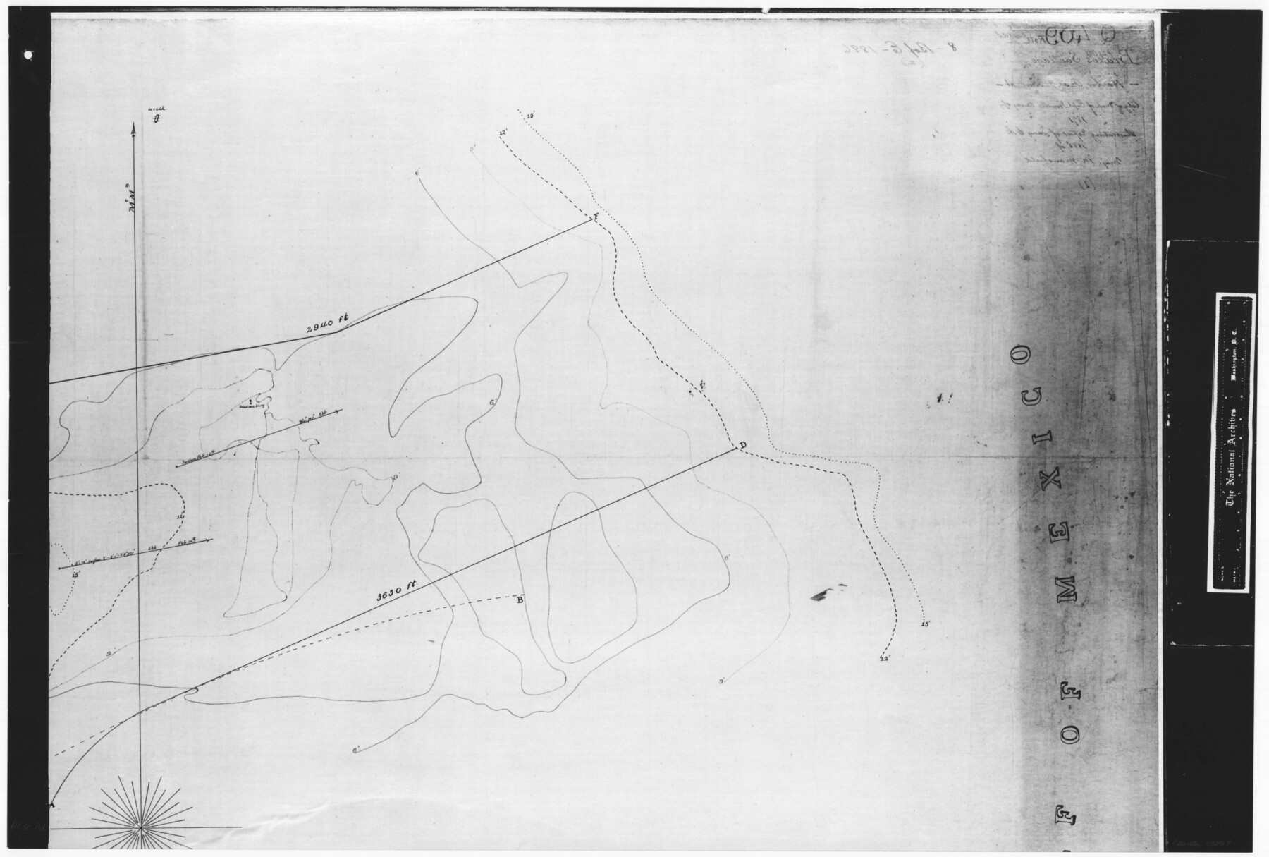
Harbor Pass and Bar at Brazos Santiago, Texas
RL-4-11d
-
Map/Doc
73037
-
Collection
General Map Collection
-
Object Dates
1871/2/10 (Creation Date)
-
People and Organizations
U. S. Army Engineers (Publisher)
H.M. Adams (Surveyor/Engineer)
-
Subjects
Nautical Charts
-
Height x Width
18.2 x 27.0 inches
46.2 x 68.6 cm
-
Comments
B/W photostat copy from National Archives in multiple pieces.
Part of: General Map Collection
Presidio County Rolled Sketch 104

Print $20.00
- Digital $50.00
Presidio County Rolled Sketch 104
1948
Size 26.1 x 40.0 inches
Map/Doc 7386
Brazos Santiago, Texas

Print $20.00
- Digital $50.00
Brazos Santiago, Texas
1867
Size 27.1 x 18.3 inches
Map/Doc 73035
Webb County Sketch File 2 and 2A

Print $20.00
- Digital $50.00
Webb County Sketch File 2 and 2A
Size 39.8 x 29.6 inches
Map/Doc 10428
San Patricio County Sketch File 42

Print $89.00
- Digital $50.00
San Patricio County Sketch File 42
1979
Size 11.3 x 8.8 inches
Map/Doc 36240
Plat of Resurvey of Sections 1, 2, 3 and 4 T. 5S., R. 16W., of the Indian Meridian, Oklahoma

Print $4.00
- Digital $50.00
Plat of Resurvey of Sections 1, 2, 3 and 4 T. 5S., R. 16W., of the Indian Meridian, Oklahoma
1917
Size 18.3 x 24.1 inches
Map/Doc 75162
Texas Official Highway Travel Map

Texas Official Highway Travel Map
Size 27.4 x 36.3 inches
Map/Doc 94307
Jeff Davis County Rolled Sketch 43

Print $20.00
- Digital $50.00
Jeff Davis County Rolled Sketch 43
2002
Size 24.2 x 24.4 inches
Map/Doc 78648
[Plat of Trinity River w/ Midstream Profile in Liberty County by US Government 1899]
![65336, [Plat of Trinity River w/ Midstream Profile in Liberty County by US Government 1899], General Map Collection](https://historictexasmaps.com/wmedia_w700/maps/65336.tif.jpg)
Print $20.00
- Digital $50.00
[Plat of Trinity River w/ Midstream Profile in Liberty County by US Government 1899]
1899
Size 10.8 x 18.3 inches
Map/Doc 65336
Menard County Sketch File 19

Print $4.00
- Digital $50.00
Menard County Sketch File 19
1905
Size 11.2 x 8.8 inches
Map/Doc 31546
Donley County Working Sketch 7

Print $20.00
- Digital $50.00
Donley County Working Sketch 7
1971
Size 23.7 x 26.1 inches
Map/Doc 68740
Williamson County Rolled Sketch 8

Print $20.00
- Digital $50.00
Williamson County Rolled Sketch 8
Size 15.1 x 18.0 inches
Map/Doc 8265
Brewster County Working Sketch 109

Print $20.00
- Digital $50.00
Brewster County Working Sketch 109
1981
Size 25.2 x 37.0 inches
Map/Doc 67709
You may also like
No. 3 Chart of Channel connecting Corpus Christi Bay with Aransas Bay, Texas

Print $20.00
- Digital $50.00
No. 3 Chart of Channel connecting Corpus Christi Bay with Aransas Bay, Texas
1878
Size 18.2 x 27.9 inches
Map/Doc 72774
Harris County

Print $20.00
- Digital $50.00
Harris County
1940
Size 36.6 x 45.1 inches
Map/Doc 73172
Hutchinson County Sketch File 17

Print $4.00
- Digital $50.00
Hutchinson County Sketch File 17
Size 6.9 x 8.8 inches
Map/Doc 27218
La Salle County Rolled Sketch 4

Print $20.00
- Digital $50.00
La Salle County Rolled Sketch 4
1937
Size 20.9 x 27.5 inches
Map/Doc 6569
Montgomery County Texas Historical Map

Montgomery County Texas Historical Map
Size 23.2 x 35.5 inches
Map/Doc 94403
El Paso County Working Sketch 31

Print $20.00
- Digital $50.00
El Paso County Working Sketch 31
1970
Size 30.9 x 26.0 inches
Map/Doc 69053
Jeff Davis County Working Sketch 12

Print $20.00
- Digital $50.00
Jeff Davis County Working Sketch 12
1948
Size 21.5 x 29.0 inches
Map/Doc 66507
Shelby County Sketch File 3

Print $4.00
- Digital $50.00
Shelby County Sketch File 3
1849
Size 11.9 x 7.9 inches
Map/Doc 36595
Zavala County Boundary File 3

Print $44.00
- Digital $50.00
Zavala County Boundary File 3
Size 9.4 x 7.3 inches
Map/Doc 60258
Hidalgo County Rolled Sketch 14

Print $40.00
- Digital $50.00
Hidalgo County Rolled Sketch 14
1963
Size 68.5 x 40.7 inches
Map/Doc 9169
Flight Mission No. DQN-5K, Frame 32, Calhoun County

Print $20.00
- Digital $50.00
Flight Mission No. DQN-5K, Frame 32, Calhoun County
1953
Size 16.5 x 16.3 inches
Map/Doc 84383
Andrews County Boundary File 2a

Print $14.00
- Digital $50.00
Andrews County Boundary File 2a
Size 11.2 x 8.9 inches
Map/Doc 49690