Red River County Sketch File 8
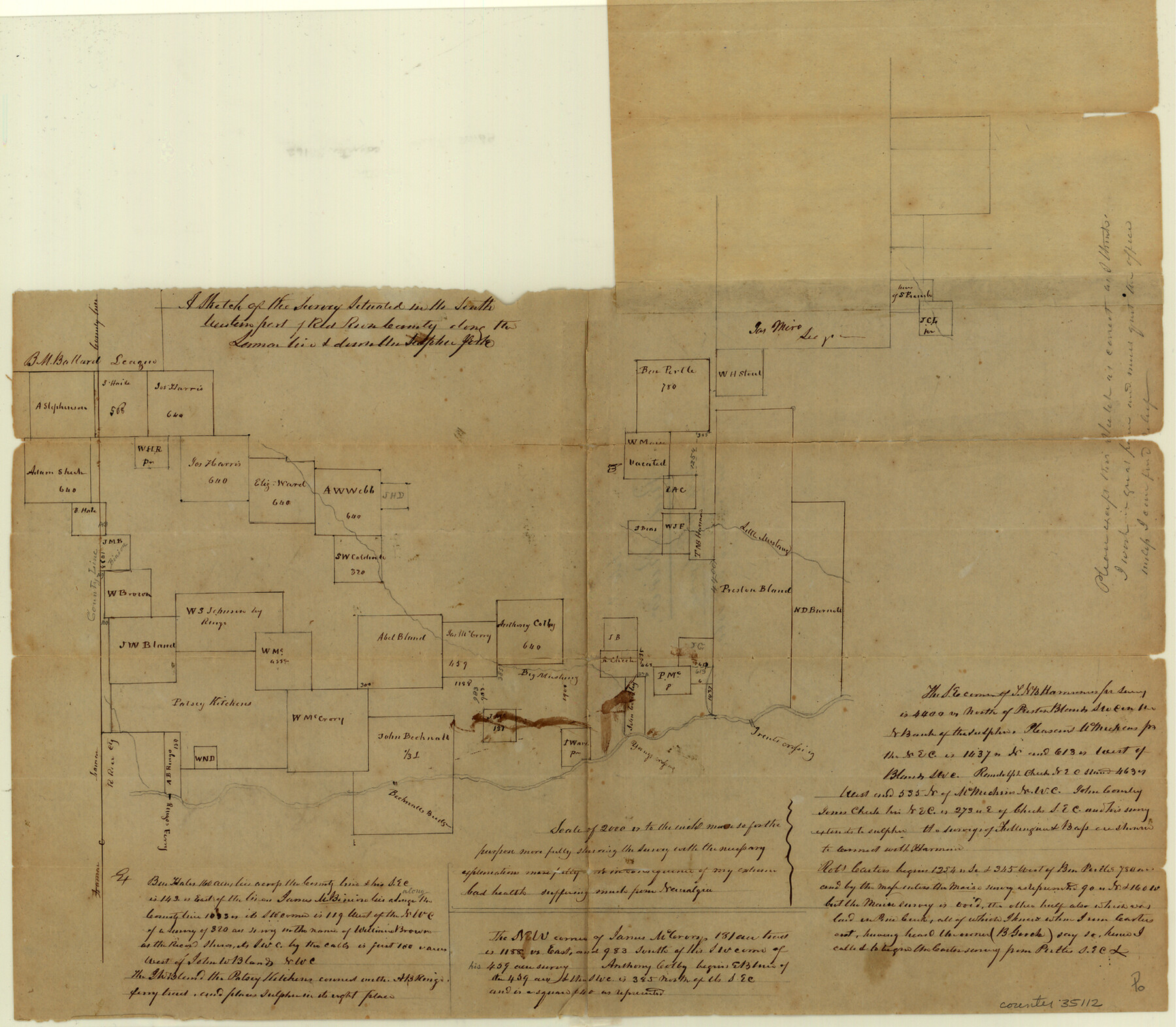
A sketch of the survey situated in the southwestern part of Red River County along the Lamar line and down the Sulphur Fork
-
Map/Doc
35112
-
Collection
General Map Collection
-
Object Dates
1/30/1860 (File Date)
-
People and Organizations
William D. Orr (Surveyor/Engineer)
-
Counties
Red River Lamar Franklin
-
Subjects
Surveying Sketch File
-
Height x Width
14.7 x 16.8 inches
37.3 x 42.7 cm
-
Medium
paper, manuscript
-
Scale
1" = 2000 varas
-
Features
Little Mustang Creek
Becknall Bridge
Big Mustang Creek
Ringo's Ferry
Trent's Crossing
Part of: General Map Collection
Jim Wells Co.

Print $20.00
- Digital $50.00
Jim Wells Co.
1966
Size 43.8 x 32.4 inches
Map/Doc 95548
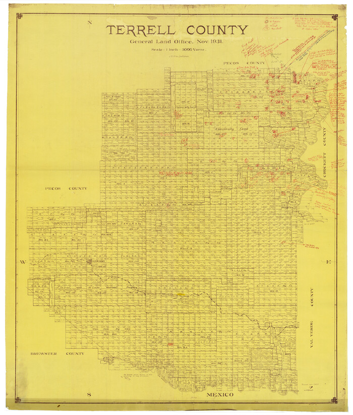
Terrell County Rolled Sketch 58
Print $40.00
- Digital $50.00
Terrell County Rolled Sketch 58
1931
Size 49.1 x 41.8 inches
Map/Doc 9993
[Sketch for Mineral Application 26501 - Sabine River, T. A. Oldhausen]
![2843, [Sketch for Mineral Application 26501 - Sabine River, T. A. Oldhausen], General Map Collection](https://historictexasmaps.com/wmedia_w700/maps/2843.tif.jpg)
Print $20.00
- Digital $50.00
[Sketch for Mineral Application 26501 - Sabine River, T. A. Oldhausen]
1931
Size 23.8 x 36.2 inches
Map/Doc 2843
San Luis Pass to East Matagorda Bay

Print $20.00
- Digital $50.00
San Luis Pass to East Matagorda Bay
1964
Size 34.7 x 46.6 inches
Map/Doc 69964
Tom Green County Working Sketch 3

Print $20.00
- Digital $50.00
Tom Green County Working Sketch 3
1933
Size 47.5 x 40.2 inches
Map/Doc 69372
Padre Island National Seashore, Texas - Dependent Resurvey

Print $4.00
- Digital $50.00
Padre Island National Seashore, Texas - Dependent Resurvey
2001
Size 18.2 x 24.3 inches
Map/Doc 60552
Newton County Sketch File 4b

Print $22.00
- Digital $50.00
Newton County Sketch File 4b
Size 7.6 x 12.2 inches
Map/Doc 32364
Terrell County Working Sketch 31

Print $20.00
- Digital $50.00
Terrell County Working Sketch 31
1945
Size 26.8 x 27.8 inches
Map/Doc 62123
Crane County Sketch File 26

Print $10.00
- Digital $50.00
Crane County Sketch File 26
1939
Size 11.5 x 9.0 inches
Map/Doc 19598
Archer County Working Sketch 15

Print $20.00
- Digital $50.00
Archer County Working Sketch 15
1948
Size 20.7 x 31.9 inches
Map/Doc 67156
[Right of Way & Track Map, The Texas & Pacific Ry. Co. Main Line]
![64674, [Right of Way & Track Map, The Texas & Pacific Ry. Co. Main Line], General Map Collection](https://historictexasmaps.com/wmedia_w700/maps/64674.tif.jpg)
Print $20.00
- Digital $50.00
[Right of Way & Track Map, The Texas & Pacific Ry. Co. Main Line]
Size 11.1 x 18.6 inches
Map/Doc 64674
Connected Map of Austin's Colony

Print $40.00
- Digital $50.00
Connected Map of Austin's Colony
1837
Size 93.2 x 43.7 inches
Map/Doc 93377
You may also like

Rusk County Rolled Sketch 8

Print $20.00
- Digital $50.00
Rusk County Rolled Sketch 8
1959
Size 22.6 x 26.3 inches
Map/Doc 7544
Upshur County Working Sketch 2

Print $20.00
- Digital $50.00
Upshur County Working Sketch 2
1934
Size 16.3 x 21.4 inches
Map/Doc 69558
Webb County Working Sketch 87

Print $20.00
- Digital $50.00
Webb County Working Sketch 87
1981
Size 46.3 x 39.6 inches
Map/Doc 72454
Brooks County Working Sketch 14

Print $20.00
- Digital $50.00
Brooks County Working Sketch 14
1944
Size 29.2 x 20.0 inches
Map/Doc 67798
Map of Wyoming Showing Test Wells for Oil and Gas, Anticlinal Axes, Oil and Gas Fields, Pipeline, Unit Areas and Land District Boundaries

Print $40.00
- Digital $50.00
Map of Wyoming Showing Test Wells for Oil and Gas, Anticlinal Axes, Oil and Gas Fields, Pipeline, Unit Areas and Land District Boundaries
1949
Size 55.2 x 42.6 inches
Map/Doc 89886
Hudspeth County Rolled Sketch 69

Print $20.00
- Digital $50.00
Hudspeth County Rolled Sketch 69
1973
Size 12.2 x 20.8 inches
Map/Doc 7717
Coleman County Sketch File 3a

Print $20.00
- Digital $50.00
Coleman County Sketch File 3a
1857
Size 12.6 x 19.2 inches
Map/Doc 11117
Section H Tech Memorial Park, Inc.

Print $20.00
- Digital $50.00
Section H Tech Memorial Park, Inc.
Size 18.0 x 11.3 inches
Map/Doc 92302
General Highway Map, Young County, Texas

Print $20.00
General Highway Map, Young County, Texas
1961
Size 18.3 x 24.8 inches
Map/Doc 79720
Duval County Sketch File 54

Print $20.00
- Digital $50.00
Duval County Sketch File 54
1937
Size 19.0 x 26.4 inches
Map/Doc 11403
Starr County Working Sketch 13

Print $20.00
- Digital $50.00
Starr County Working Sketch 13
1951
Size 19.3 x 28.8 inches
Map/Doc 63929