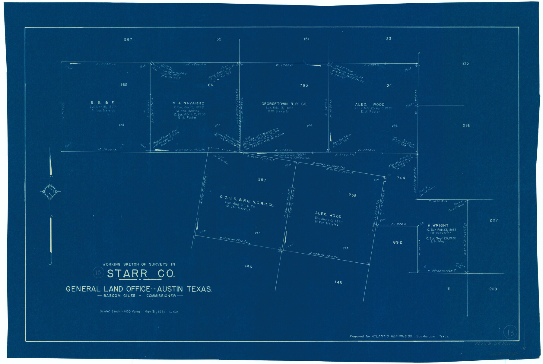
Starr County Working Sketch 13
-
Map/Doc
63929
-
Collection
General Map Collection
-
Object Dates
5/31/1951 (Creation Date)
-
People and Organizations
Otto G. Kurio (Draftsman)
-
Counties
Starr
-
Subjects
Surveying Working Sketch
-
Height x Width
19.3 x 28.8 inches
49.0 x 73.2 cm
-
Scale
1" = 400 varas
Part of: General Map Collection
Harrison County Working Sketch 33

Print $20.00
- Digital $50.00
Harrison County Working Sketch 33
2015
Size 19.8 x 22.8 inches
Map/Doc 93725
Hansford County Boundary File 1

Print $24.00
- Digital $50.00
Hansford County Boundary File 1
Size 9.2 x 8.6 inches
Map/Doc 54232
Stephens County Working Sketch 17

Print $20.00
- Digital $50.00
Stephens County Working Sketch 17
1968
Size 22.7 x 29.1 inches
Map/Doc 63960
[F. W. & D. C. Ry. Co. Alignment and Right of Way Map, Clay County]
![64737, [F. W. & D. C. Ry. Co. Alignment and Right of Way Map, Clay County], General Map Collection](https://historictexasmaps.com/wmedia_w700/maps/64737-GC.tif.jpg)
Print $20.00
- Digital $50.00
[F. W. & D. C. Ry. Co. Alignment and Right of Way Map, Clay County]
1927
Size 18.6 x 11.8 inches
Map/Doc 64737
Flight Mission No. DQN-7K, Frame 31, Calhoun County

Print $20.00
- Digital $50.00
Flight Mission No. DQN-7K, Frame 31, Calhoun County
1953
Size 18.5 x 22.1 inches
Map/Doc 84469
Duval County Sketch File 82

Print $10.00
- Digital $50.00
Duval County Sketch File 82
1933
Size 11.3 x 8.8 inches
Map/Doc 21516
Presidio County Sketch File 5

Print $4.00
- Digital $50.00
Presidio County Sketch File 5
1872
Size 12.9 x 8.2 inches
Map/Doc 34433
Guadalupe County Sketch File 16

Print $22.00
- Digital $50.00
Guadalupe County Sketch File 16
Size 15.7 x 12.4 inches
Map/Doc 24694
Edwards County Sketch File 18

Print $6.00
- Digital $50.00
Edwards County Sketch File 18
Size 16.3 x 10.6 inches
Map/Doc 21738
Harris County Working Sketch 123

Print $20.00
- Digital $50.00
Harris County Working Sketch 123
1993
Size 19.5 x 17.0 inches
Map/Doc 66015
Flight Mission No. BRA-8M, Frame 74, Jefferson County

Print $20.00
- Digital $50.00
Flight Mission No. BRA-8M, Frame 74, Jefferson County
1953
Size 18.6 x 22.2 inches
Map/Doc 85594
Flight Mission No. CRK-3P, Frame 127, Refugio County

Print $20.00
- Digital $50.00
Flight Mission No. CRK-3P, Frame 127, Refugio County
1956
Size 18.6 x 22.3 inches
Map/Doc 86915
You may also like
Burnet County Working Sketch 23

Print $40.00
- Digital $50.00
Burnet County Working Sketch 23
1987
Size 43.8 x 51.9 inches
Map/Doc 67866
Alamo Defenders Heritage Map of Texas

Print $20.00
Alamo Defenders Heritage Map of Texas
2025
Size 36.0 x 24.0 inches
Map/Doc 97433
Duval County Sketch File 7

Print $4.00
- Digital $50.00
Duval County Sketch File 7
1875
Size 10.9 x 8.6 inches
Map/Doc 21294
Flight Mission No. DAG-24K, Frame 134, Matagorda County

Print $20.00
- Digital $50.00
Flight Mission No. DAG-24K, Frame 134, Matagorda County
1953
Size 17.1 x 15.6 inches
Map/Doc 86552
Flight Mission No. CGI-1N, Frame 135, Cameron County

Print $20.00
- Digital $50.00
Flight Mission No. CGI-1N, Frame 135, Cameron County
1955
Size 17.2 x 18.7 inches
Map/Doc 84491
Travis County Rolled Sketch 15

Print $20.00
- Digital $50.00
Travis County Rolled Sketch 15
1939
Size 25.4 x 37.6 inches
Map/Doc 10011
Panola County Sketch File 19

Print $14.00
- Digital $50.00
Panola County Sketch File 19
Size 11.7 x 7.7 inches
Map/Doc 33478
Henderson County Rolled Sketch 11

Print $20.00
- Digital $50.00
Henderson County Rolled Sketch 11
1915
Size 29.4 x 42.4 inches
Map/Doc 75958
Matagorda Light to Aransas Pass

Print $20.00
- Digital $50.00
Matagorda Light to Aransas Pass
1961
Size 35.9 x 44.7 inches
Map/Doc 73396
Cass County Working Sketch 17

Print $20.00
- Digital $50.00
Cass County Working Sketch 17
1958
Size 36.8 x 42.7 inches
Map/Doc 67920
Flight Mission No. BRA-7M, Frame 85, Jefferson County

Print $20.00
- Digital $50.00
Flight Mission No. BRA-7M, Frame 85, Jefferson County
1953
Size 18.7 x 22.4 inches
Map/Doc 85507
Brewster County Rolled Sketch 80

Print $40.00
- Digital $50.00
Brewster County Rolled Sketch 80
1943
Size 51.6 x 42.7 inches
Map/Doc 8493