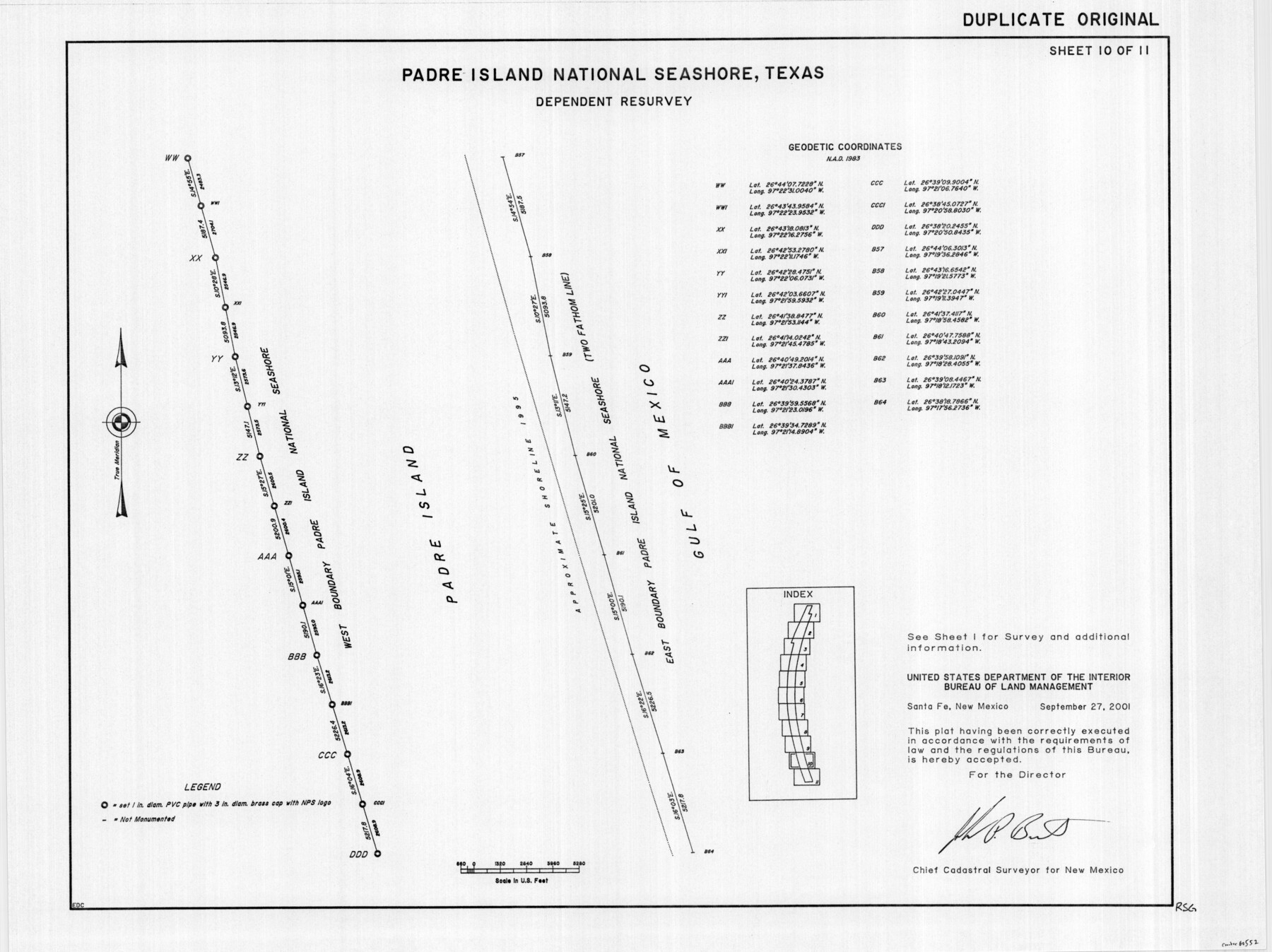
Padre Island National Seashore, Texas - Dependent Resurvey
-
Map/Doc
60552
-
Collection
General Map Collection
-
Object Dates
2001 (Creation Date)
-
Height x Width
18.2 x 24.3 inches
46.2 x 61.7 cm
Part of: General Map Collection
Menard County Rolled Sketch 7

Print $20.00
- Digital $50.00
Menard County Rolled Sketch 7
Size 43.2 x 37.3 inches
Map/Doc 9509
Sabine River, Merrill Lake Sheet

Print $20.00
- Digital $50.00
Sabine River, Merrill Lake Sheet
1933
Size 26.4 x 43.6 inches
Map/Doc 65137
Kimble County Working Sketch 61

Print $20.00
- Digital $50.00
Kimble County Working Sketch 61
1964
Size 23.4 x 21.5 inches
Map/Doc 70129
Flight Mission No. BRE-1P, Frame 105, Nueces County

Print $20.00
- Digital $50.00
Flight Mission No. BRE-1P, Frame 105, Nueces County
1956
Size 18.4 x 22.2 inches
Map/Doc 86676
Hood County Sketch File 21

Print $12.00
- Digital $50.00
Hood County Sketch File 21
1873
Size 7.8 x 6.7 inches
Map/Doc 26609
Jim Hogg County Working Sketch 10

Print $20.00
- Digital $50.00
Jim Hogg County Working Sketch 10
Size 18.8 x 15.6 inches
Map/Doc 66596
Wichita County Sketch File 20

Print $20.00
- Digital $50.00
Wichita County Sketch File 20
Size 12.0 x 22.5 inches
Map/Doc 12683
Presidio County Rolled Sketch 138

Print $20.00
- Digital $50.00
Presidio County Rolled Sketch 138
2000
Size 36.7 x 25.1 inches
Map/Doc 7405
Cass County Working Sketch 22

Print $20.00
- Digital $50.00
Cass County Working Sketch 22
1961
Size 21.7 x 34.0 inches
Map/Doc 67925
Hall County Rolled Sketch 5

Print $20.00
- Digital $50.00
Hall County Rolled Sketch 5
1914
Size 30.2 x 37.1 inches
Map/Doc 6049
Willacy County

Print $20.00
- Digital $50.00
Willacy County
1921
Size 25.2 x 33.1 inches
Map/Doc 1901
Erath County Working Sketch 32

Print $20.00
- Digital $50.00
Erath County Working Sketch 32
1971
Size 32.0 x 25.8 inches
Map/Doc 69113
You may also like
Flight Mission No. DIX-10P, Frame 165, Aransas County

Print $20.00
- Digital $50.00
Flight Mission No. DIX-10P, Frame 165, Aransas County
1956
Size 18.6 x 22.3 inches
Map/Doc 83955
Harris County Sketch File 84

Print $20.00
- Digital $50.00
Harris County Sketch File 84
1950
Size 23.1 x 35.7 inches
Map/Doc 11672
Harrison County Sketch File 16

Print $20.00
- Digital $50.00
Harrison County Sketch File 16
1910
Size 41.7 x 27.5 inches
Map/Doc 10488
Controlled Mosaic by Jack Amman Photogrammetric Engineers, Inc - Sheet 2

Print $20.00
- Digital $50.00
Controlled Mosaic by Jack Amman Photogrammetric Engineers, Inc - Sheet 2
1954
Size 20.0 x 24.0 inches
Map/Doc 83446
Pecos County Working Sketch 74

Print $40.00
- Digital $50.00
Pecos County Working Sketch 74
1957
Size 101.0 x 38.7 inches
Map/Doc 71546
Glasscock County

Print $20.00
- Digital $50.00
Glasscock County
1899
Size 38.1 x 33.9 inches
Map/Doc 4707
"G" Sketch from Gaines County

Print $20.00
- Digital $50.00
"G" Sketch from Gaines County
1902
Size 31.6 x 21.8 inches
Map/Doc 90845
Texas Aerial Photo-Illustrated Map

Texas Aerial Photo-Illustrated Map
Size 21.3 x 28.3 inches
Map/Doc 94397
Houston County Sketch File 24

Print $4.00
- Digital $50.00
Houston County Sketch File 24
1867
Size 14.2 x 8.2 inches
Map/Doc 26796
Anderson County Sketch File 24

Print $60.00
- Digital $50.00
Anderson County Sketch File 24
1942
Size 13.2 x 18.2 inches
Map/Doc 10803
Three Through Trains for Texas Travelers via Katy Line - Missouri, Kansas and Texas Railway from Chicago, St. Louis, Kansas City and a comprehensive local service reaching all points in Missouri, Kansas, Texas and Indian Territory

Three Through Trains for Texas Travelers via Katy Line - Missouri, Kansas and Texas Railway from Chicago, St. Louis, Kansas City and a comprehensive local service reaching all points in Missouri, Kansas, Texas and Indian Territory
Size 9.5 x 6.3 inches
Map/Doc 96605
Crockett County Rolled Sketch S

Print $20.00
- Digital $50.00
Crockett County Rolled Sketch S
Size 8.3 x 21.2 inches
Map/Doc 5639