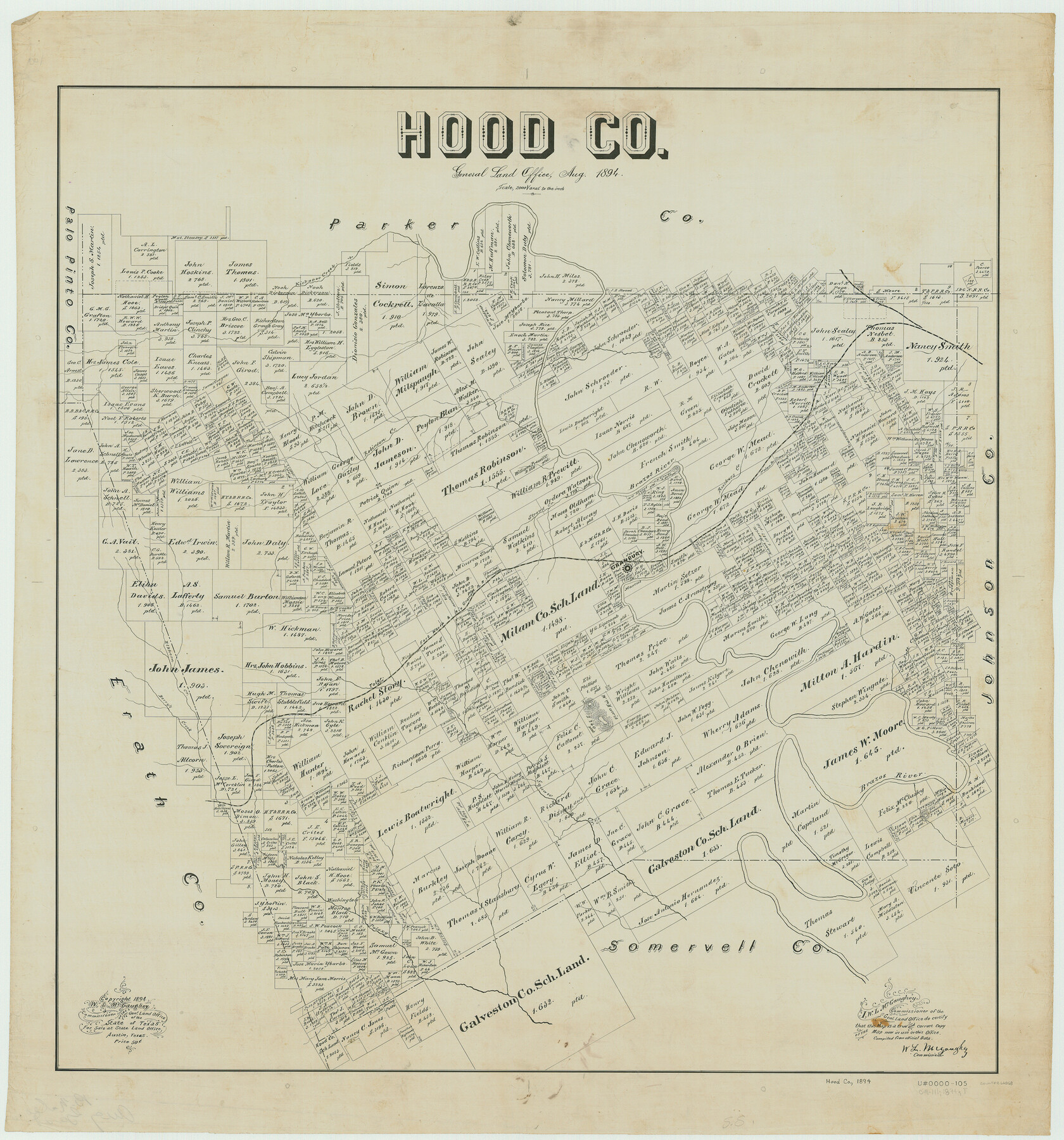
Hood Co.
-
Map/Doc
66868
-
Collection
General Map Collection
-
Object Dates
1894 (Creation Date)
-
People and Organizations
Texas General Land Office (Publisher)
W.L. McGaughey (GLO Commissioner)
-
Counties
Hood
-
Subjects
County
-
Height x Width
32.3 x 30.2 inches
82.0 x 76.7 cm
-
Comments
Copyrighted 1894.
Part of: General Map Collection
Nueces County Rolled Sketch 101

Print $88.00
Nueces County Rolled Sketch 101
1985
Size 18.2 x 24.6 inches
Map/Doc 7061
Fisher County Sketch File 13

Print $20.00
- Digital $50.00
Fisher County Sketch File 13
Size 18.3 x 17.7 inches
Map/Doc 11480
Liberty County Working Sketch 11

Print $20.00
- Digital $50.00
Liberty County Working Sketch 11
1913
Size 21.5 x 28.9 inches
Map/Doc 70470
Blanco County Working Sketch 39

Print $20.00
- Digital $50.00
Blanco County Working Sketch 39
1985
Size 11.9 x 18.4 inches
Map/Doc 67399
Maps & Lists Showing Prison Lands (Oil & Gas) Leased as of June 1955

Digital $50.00
Maps & Lists Showing Prison Lands (Oil & Gas) Leased as of June 1955
Size 8.9 x 11.3 inches
Map/Doc 62870
Polk County Sketch File 30a

Print $8.00
- Digital $50.00
Polk County Sketch File 30a
Size 14.2 x 8.8 inches
Map/Doc 34215
Right of Way and Track Map, Dayton-Goose Creek Ry. Co., Station 612+40 to Station 792+00

Print $40.00
- Digital $50.00
Right of Way and Track Map, Dayton-Goose Creek Ry. Co., Station 612+40 to Station 792+00
1917
Size 25.3 x 56.5 inches
Map/Doc 64368
Runnels County Rolled Sketch 40

Print $20.00
- Digital $50.00
Runnels County Rolled Sketch 40
Size 32.3 x 38.9 inches
Map/Doc 7528
Duval County Sketch File 66

Print $12.00
- Digital $50.00
Duval County Sketch File 66
1944
Size 14.5 x 8.8 inches
Map/Doc 21444
Map of King County

Print $20.00
- Digital $50.00
Map of King County
1903
Size 44.8 x 42.4 inches
Map/Doc 16867
Van Zandt County Sketch File 22a

Print $4.00
- Digital $50.00
Van Zandt County Sketch File 22a
1858
Size 7.5 x 8.2 inches
Map/Doc 39435
Webb County Sketch File 5a

Print $8.00
- Digital $50.00
Webb County Sketch File 5a
1877
Size 12.9 x 8.2 inches
Map/Doc 39729
You may also like
Edwards County Rolled Sketch 20

Print $20.00
- Digital $50.00
Edwards County Rolled Sketch 20
1947
Size 31.6 x 40.4 inches
Map/Doc 8844
Photo Index of Texas Coast - Sheet 2 of 6

Print $20.00
- Digital $50.00
Photo Index of Texas Coast - Sheet 2 of 6
1954
Size 20.0 x 24.0 inches
Map/Doc 83440
General Highway Map. Detail of Cities and Towns in Tarrant County, Texas. City Map, Fort Worth and vicinity, Tarrant County, Texas

Print $20.00
General Highway Map. Detail of Cities and Towns in Tarrant County, Texas. City Map, Fort Worth and vicinity, Tarrant County, Texas
1961
Size 18.2 x 24.8 inches
Map/Doc 79669
Brewster County Sketch File N-30

Print $6.00
- Digital $50.00
Brewster County Sketch File N-30
1969
Size 11.2 x 8.9 inches
Map/Doc 15708
Houston Ship Channel, Atkinson Island to Alexander Island

Print $40.00
- Digital $50.00
Houston Ship Channel, Atkinson Island to Alexander Island
1973
Size 36.7 x 50.2 inches
Map/Doc 69902
Bandera County Working Sketch 33

Print $20.00
- Digital $50.00
Bandera County Working Sketch 33
1961
Size 22.4 x 28.8 inches
Map/Doc 67629
Fort Bend County Sketch File 19

Print $4.00
- Digital $50.00
Fort Bend County Sketch File 19
1890
Size 13.0 x 8.7 inches
Map/Doc 22951
Blanco County Boundary File 10

Print $26.00
- Digital $50.00
Blanco County Boundary File 10
Size 8.9 x 7.6 inches
Map/Doc 50576
Nueces County Rolled Sketch 113B

Print $20.00
- Digital $50.00
Nueces County Rolled Sketch 113B
1972
Size 18.3 x 23.6 inches
Map/Doc 7124
Hemphill County Sketch File 6

Print $8.00
- Digital $50.00
Hemphill County Sketch File 6
1902
Size 14.2 x 8.6 inches
Map/Doc 26299

San Patricio County Sketch File 36

Print $26.00
- Digital $50.00
San Patricio County Sketch File 36
1940
Size 11.3 x 8.7 inches
Map/Doc 36129