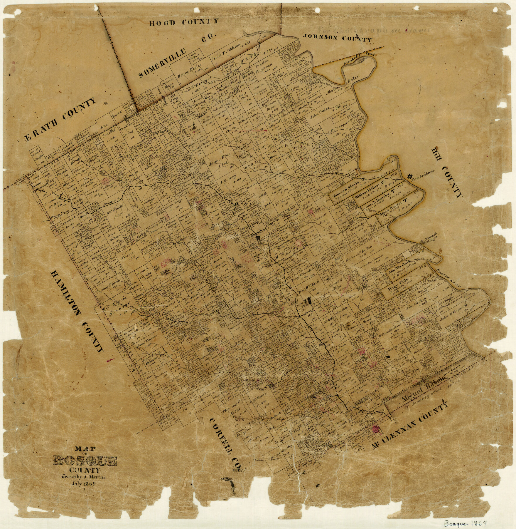
Map of Bosque County
-
Map/Doc
3313
-
Collection
General Map Collection
-
Object Dates
7/1869 (Creation Date)
-
People and Organizations
Joseph Martin (Draftsman)
-
Counties
Bosque
-
Subjects
County
-
Height x Width
24.1 x 23.7 inches
61.2 x 60.2 cm
-
Features
Belton Road
Middle Bosque River
Hogg Creek
South Fork of Neels Creek
Neels Creek
Childres [sic] Creek
Turkeys Creek
Cary Creek
Brazos River
Fall Creek
East Meridian Creek
Bee Creek
Rocky Creek
Towash Village
Hill Creek
Spring Creek
Honey Creek
Bosque River
Meridian
Cedron Creek
North Cedron Creek
Fort Graham
Steels Creek
Duffau Creek
East Bosque River
Mesquite Creek
Grass Creek
Kimbell's Bend
Part of: General Map Collection
Jackson County Sketch File 30

Print $52.00
- Digital $50.00
Jackson County Sketch File 30
1944
Size 14.2 x 8.5 inches
Map/Doc 27730
Zavala County Working Sketch 13

Print $20.00
- Digital $50.00
Zavala County Working Sketch 13
1975
Size 20.1 x 27.4 inches
Map/Doc 62088
Wharton County Sketch File 3a

Print $4.00
- Digital $50.00
Wharton County Sketch File 3a
1875
Size 6.8 x 4.6 inches
Map/Doc 39917
Kimble County Working Sketch 14

Print $20.00
- Digital $50.00
Kimble County Working Sketch 14
1923
Size 17.2 x 13.2 inches
Map/Doc 70082

Flight Mission No. DAG-24K, Frame 50, Matagorda County

Print $20.00
- Digital $50.00
Flight Mission No. DAG-24K, Frame 50, Matagorda County
1953
Size 16.0 x 16.0 inches
Map/Doc 86537
Nacogdoches County Sketch File 19

Print $12.00
- Digital $50.00
Nacogdoches County Sketch File 19
1846
Size 17.0 x 11.0 inches
Map/Doc 32270
Hartley County Boundary File 4a

Print $38.00
- Digital $50.00
Hartley County Boundary File 4a
Size 14.2 x 9.0 inches
Map/Doc 54505
Flight Mission No. CGI-3N, Frame 133, Cameron County

Print $20.00
- Digital $50.00
Flight Mission No. CGI-3N, Frame 133, Cameron County
1954
Size 18.5 x 22.1 inches
Map/Doc 84606
Montgomery County Working Sketch 74

Print $20.00
- Digital $50.00
Montgomery County Working Sketch 74
1981
Size 37.6 x 45.6 inches
Map/Doc 71181
Edwards County Rolled Sketch 26

Print $20.00
- Digital $50.00
Edwards County Rolled Sketch 26
1958
Size 25.0 x 17.5 inches
Map/Doc 5812
Fractional Township No. 7 South Range No. 15 East of the Indian Meridian, Indian Territory

Print $20.00
- Digital $50.00
Fractional Township No. 7 South Range No. 15 East of the Indian Meridian, Indian Territory
1896
Size 19.2 x 24.3 inches
Map/Doc 75226
You may also like
General Highway Map, Kleberg County, Texas

Print $20.00
General Highway Map, Kleberg County, Texas
1940
Size 24.9 x 18.4 inches
Map/Doc 79165
Wise County Sketch File 40

Print $4.00
- Digital $50.00
Wise County Sketch File 40
1875
Size 8.0 x 10.6 inches
Map/Doc 40597
Irion County Working Sketch 10

Print $20.00
- Digital $50.00
Irion County Working Sketch 10
1940
Size 29.6 x 43.5 inches
Map/Doc 66419
Donley County Sketch File B8

Print $20.00
- Digital $50.00
Donley County Sketch File B8
1920
Size 15.3 x 15.9 inches
Map/Doc 11378
San Patricio County Rolled Sketch 20

Print $20.00
- Digital $50.00
San Patricio County Rolled Sketch 20
1953
Size 37.6 x 31.9 inches
Map/Doc 7578
Cass County Working Sketch 36

Print $20.00
- Digital $50.00
Cass County Working Sketch 36
1982
Size 37.9 x 39.4 inches
Map/Doc 67939
Garza County Sketch File 31

Print $10.00
- Digital $50.00
Garza County Sketch File 31
1914
Size 13.4 x 8.9 inches
Map/Doc 24104
Limestone County Rolled Sketch 4

Print $20.00
- Digital $50.00
Limestone County Rolled Sketch 4
1921
Size 35.1 x 35.1 inches
Map/Doc 9573
Johnson County Sketch File 22

Print $20.00
- Digital $50.00
Johnson County Sketch File 22
1873
Size 18.8 x 16.2 inches
Map/Doc 11891
Map Showing the Relative Positions of the Various Surveys Delineated Thereon

Print $20.00
- Digital $50.00
Map Showing the Relative Positions of the Various Surveys Delineated Thereon
Size 23.0 x 18.6 inches
Map/Doc 91500
Knox County Working Sketch 8

Print $20.00
- Digital $50.00
Knox County Working Sketch 8
1942
Size 38.7 x 14.3 inches
Map/Doc 70250
The Judicial District/County of Menard. Abolished, Spring 1842

Print $20.00
The Judicial District/County of Menard. Abolished, Spring 1842
2020
Size 22.4 x 21.7 inches
Map/Doc 96337