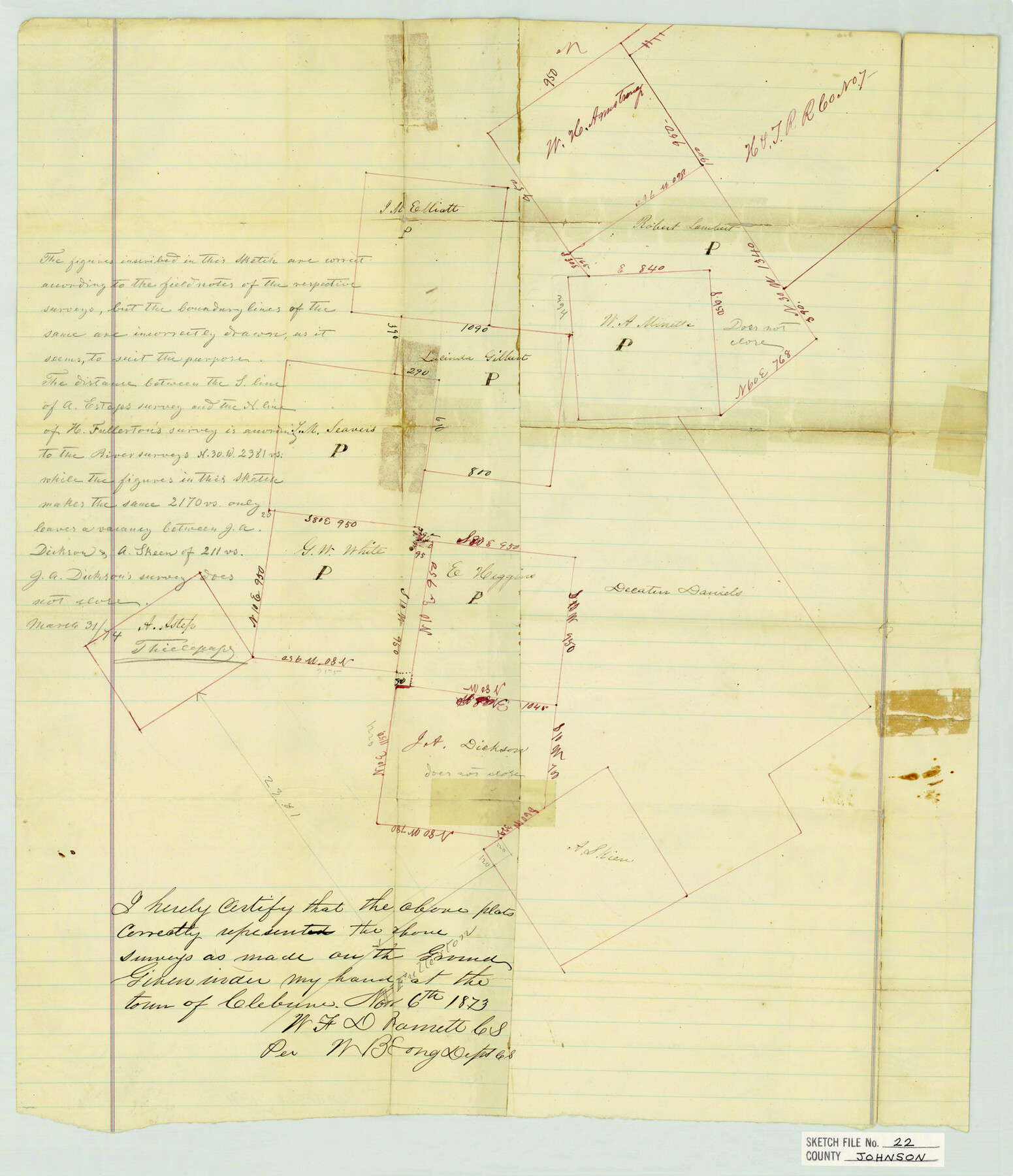
Johnson County Sketch File 22
[Sketch of surveys near the Somervell County line southwest from Cleburne]
-
Map/Doc
11891
-
Collection
General Map Collection
-
Object Dates
11/6/1873 (Creation Date)
11/13/1873 (File Date)
-
People and Organizations
W.B. Long (Surveyor/Engineer)
-
Counties
Johnson Somervell
-
Subjects
Surveying Sketch File
-
Height x Width
18.8 x 16.2 inches
47.8 x 41.2 cm
-
Medium
paper, manuscript
Part of: General Map Collection
Van Zandt County Sketch File 37

Print $4.00
- Digital $50.00
Van Zandt County Sketch File 37
1861
Size 12.2 x 7.8 inches
Map/Doc 39480
Flight Mission No. DIX-6P, Frame 128, Aransas County

Print $20.00
- Digital $50.00
Flight Mission No. DIX-6P, Frame 128, Aransas County
1956
Size 19.2 x 22.6 inches
Map/Doc 83834
Harrison County Sketch File 20

Print $20.00
- Digital $50.00
Harrison County Sketch File 20
1946
Size 26.4 x 21.8 inches
Map/Doc 11693

Brazos River, Sandpit Special Sheet

Print $6.00
- Digital $50.00
Brazos River, Sandpit Special Sheet
1936
Size 33.8 x 24.7 inches
Map/Doc 65279
Waller County Working Sketch 3

Print $20.00
- Digital $50.00
Waller County Working Sketch 3
1959
Size 35.4 x 28.8 inches
Map/Doc 72302
Travis County Sketch File 75A

Print $20.00
- Digital $50.00
Travis County Sketch File 75A
1992
Size 37.9 x 28.8 inches
Map/Doc 12478
Tom Green County Rolled Sketch 28

Print $20.00
- Digital $50.00
Tom Green County Rolled Sketch 28
Size 25.3 x 25.4 inches
Map/Doc 8008
Dallas County Sketch File 22

Print $6.00
- Digital $50.00
Dallas County Sketch File 22
1891
Size 9.5 x 10.9 inches
Map/Doc 20454
Duval County Boundary File 2

Print $32.00
- Digital $50.00
Duval County Boundary File 2
Size 12.4 x 8.1 inches
Map/Doc 52703
Lipscomb County Boundary File 9

Print $8.00
- Digital $50.00
Lipscomb County Boundary File 9
Size 11.2 x 8.5 inches
Map/Doc 56335
[Sketch showing the Rio Grande with towns and features annotated]
![72897, [Sketch showing the Rio Grande with towns and features annotated], General Map Collection](https://historictexasmaps.com/wmedia_w700/maps/72897.tif.jpg)
Print $20.00
- Digital $50.00
[Sketch showing the Rio Grande with towns and features annotated]
1854
Size 23.7 x 18.4 inches
Map/Doc 72897
You may also like
Calhoun County Rolled Sketch 14

Print $20.00
- Digital $50.00
Calhoun County Rolled Sketch 14
Size 22.1 x 40.5 inches
Map/Doc 5454
The Republic County of Travis. Spring 1842

Print $20.00
The Republic County of Travis. Spring 1842
2020
Size 20.8 x 21.6 inches
Map/Doc 96292
Live Oak County Sketch File 3

Print $22.00
- Digital $50.00
Live Oak County Sketch File 3
1848
Size 12.6 x 16.1 inches
Map/Doc 30255
Sketch of the Northwest Portion of Hutchinson County

Print $20.00
- Digital $50.00
Sketch of the Northwest Portion of Hutchinson County
Size 19.8 x 13.6 inches
Map/Doc 91139
Hardeman County Sketch File 4

Print $6.00
- Digital $50.00
Hardeman County Sketch File 4
Size 9.3 x 8.2 inches
Map/Doc 24991
Railroad Track Map, H&TCRRCo., Falls County, Texas

Print $4.00
- Digital $50.00
Railroad Track Map, H&TCRRCo., Falls County, Texas
1918
Size 11.7 x 18.3 inches
Map/Doc 62853
Hopkins County

Print $20.00
- Digital $50.00
Hopkins County
1942
Size 45.7 x 42.2 inches
Map/Doc 95533
[Surveys near Carancahua Bay]
![106, [Surveys near Carancahua Bay], General Map Collection](https://historictexasmaps.com/wmedia_w700/maps/106.tif.jpg)
Print $2.00
- Digital $50.00
[Surveys near Carancahua Bay]
1844
Size 13.1 x 8.0 inches
Map/Doc 106
Pecos County Sketch File 29b

Print $12.00
- Digital $50.00
Pecos County Sketch File 29b
1929
Size 14.3 x 8.8 inches
Map/Doc 33692
Dimmit County Working Sketch 19

Print $20.00
- Digital $50.00
Dimmit County Working Sketch 19
1948
Size 27.4 x 23.3 inches
Map/Doc 68680
Flight Mission No. BRA-7M, Frame 139, Jefferson County

Print $20.00
- Digital $50.00
Flight Mission No. BRA-7M, Frame 139, Jefferson County
1953
Size 18.7 x 22.4 inches
Map/Doc 85533
Right of Way and Track Map International & Gt Northern Ry. operated by the International & Gt. Northern Ry. Co., San Antonio Division

Print $40.00
- Digital $50.00
Right of Way and Track Map International & Gt Northern Ry. operated by the International & Gt. Northern Ry. Co., San Antonio Division
1917
Size 25.6 x 58.1 inches
Map/Doc 64587