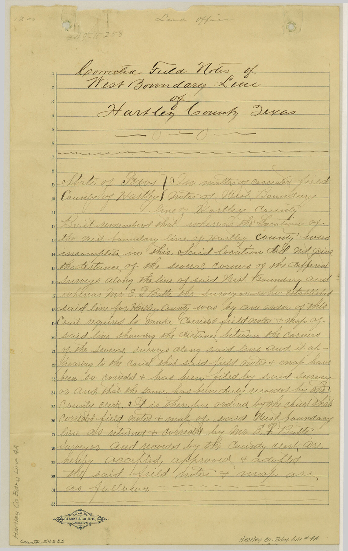
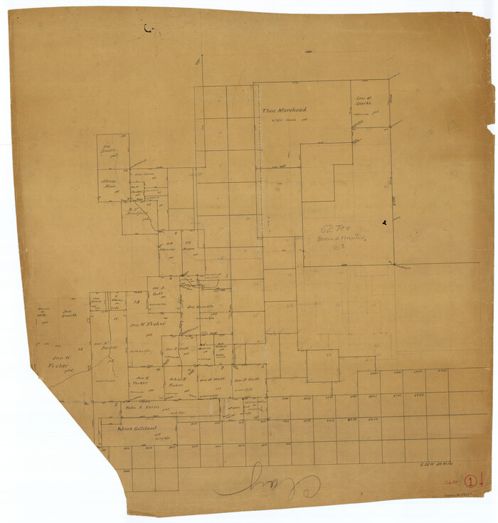
Hartley County Boundary File 4a
Corrected Map and Field Notes of the West Boundary Line of Hartley County Tex.
-
Map/Doc
54505
-
Collection
General Map Collection
-
Counties
Hartley
-
Subjects
County Boundaries
-
Height x Width
14.2 x 9.0 inches
36.1 x 22.9 cm
Part of: General Map Collection
Jeff Davis Co.

Print $40.00
- Digital $50.00
Jeff Davis Co.
1915
Size 30.4 x 52.2 inches
Map/Doc 66881
Wilbarger County Sketch File 4

Print $4.00
- Digital $50.00
Wilbarger County Sketch File 4
1883
Size 12.7 x 8.2 inches
Map/Doc 40168
El Paso County Working Sketch 59

Print $20.00
- Digital $50.00
El Paso County Working Sketch 59
2000
Size 28.1 x 35.7 inches
Map/Doc 69081
Runnels County Working Sketch 36

Print $20.00
- Digital $50.00
Runnels County Working Sketch 36
1984
Size 31.9 x 39.2 inches
Map/Doc 63635
Mitchell County Boundary File 1a

Print $32.00
- Digital $50.00
Mitchell County Boundary File 1a
Size 13.4 x 8.6 inches
Map/Doc 57344
Blanco County Sketch File 36

Print $8.00
- Digital $50.00
Blanco County Sketch File 36
1889
Size 11.2 x 8.8 inches
Map/Doc 14642
Edwards County Working Sketch 110

Print $40.00
- Digital $50.00
Edwards County Working Sketch 110
1972
Size 49.7 x 39.6 inches
Map/Doc 68986
Flight Mission No. BQY-4M, Frame 124, Harris County

Print $20.00
- Digital $50.00
Flight Mission No. BQY-4M, Frame 124, Harris County
1953
Size 18.7 x 22.4 inches
Map/Doc 85292
Clay County Working Sketch 1
Print $20.00
- Digital $50.00
Clay County Working Sketch 1
Size 30.7 x 29.3 inches
Map/Doc 68024
Dimmit County Working Sketch 49

Print $40.00
- Digital $50.00
Dimmit County Working Sketch 49
1980
Size 78.8 x 44.7 inches
Map/Doc 68710
Flight Mission No. CRC-3R, Frame 25, Chambers County

Print $20.00
- Digital $50.00
Flight Mission No. CRC-3R, Frame 25, Chambers County
1956
Size 18.5 x 22.3 inches
Map/Doc 84799
Morris County Rolled Sketch 2A

Print $20.00
- Digital $50.00
Morris County Rolled Sketch 2A
Size 24.0 x 18.8 inches
Map/Doc 10237
You may also like
Map of Jack County

Print $20.00
- Digital $50.00
Map of Jack County
1896
Size 20.3 x 17.7 inches
Map/Doc 3699
Baylor County Sketch File 32

Print $10.00
- Digital $50.00
Baylor County Sketch File 32
Size 10.2 x 8.2 inches
Map/Doc 14238
General Highway Map, Kendall County, Texas

Print $20.00
General Highway Map, Kendall County, Texas
1961
Size 18.3 x 24.6 inches
Map/Doc 79549
Moore County Sketch File 1

Print $20.00
- Digital $50.00
Moore County Sketch File 1
Size 28.9 x 38.6 inches
Map/Doc 10552
Reconnaissance of Aransas Pass, Texas

Print $20.00
Reconnaissance of Aransas Pass, Texas
1853
Size 14.9 x 12.4 inches
Map/Doc 76250

Fort Bend Co.

Print $20.00
- Digital $50.00
Fort Bend Co.
1931
Size 40.5 x 41.3 inches
Map/Doc 77282
Flight Mission No. CRK-8P, Frame 114, Refugio County

Print $20.00
- Digital $50.00
Flight Mission No. CRK-8P, Frame 114, Refugio County
1956
Size 18.3 x 22.1 inches
Map/Doc 86969
Map of Texas coastal area showing submerged area to which counties along the Gulf of Mexico are entitled

Print $20.00
- Digital $50.00
Map of Texas coastal area showing submerged area to which counties along the Gulf of Mexico are entitled
1939
Size 28.3 x 44.2 inches
Map/Doc 3105
Map of Great Britain and Ireland engraved to illustrate Mitchell's school and family geography

Print $20.00
- Digital $50.00
Map of Great Britain and Ireland engraved to illustrate Mitchell's school and family geography
1840
Size 11.8 x 9.5 inches
Map/Doc 93503
Map of Bexar County

Print $20.00
- Digital $50.00
Map of Bexar County
1896
Size 45.2 x 40.2 inches
Map/Doc 4885
Brewster County Working Sketch 22

Print $20.00
- Digital $50.00
Brewster County Working Sketch 22
1939
Size 18.4 x 30.7 inches
Map/Doc 67556