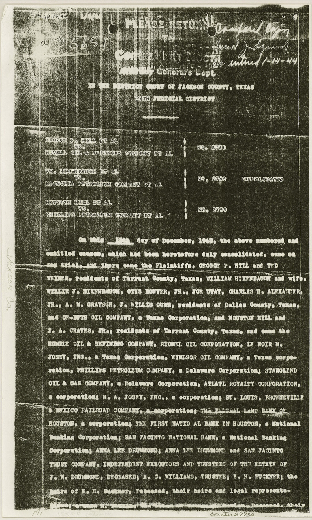
Jackson County Sketch File 30
[Final Judgement on Menefee Lakes 1 and 2 and Bayous 1 and 2]
-
Map/Doc
27730
-
Collection
General Map Collection
-
Object Dates
1944/1/14 (Creation Date)
1991/9/16 (File Date)
-
Counties
Jackson
-
Subjects
Surveying Sketch File
-
Height x Width
14.2 x 8.5 inches
36.1 x 21.6 cm
-
Medium
paper, photocopy
-
Comments
See Jackson County Rolled Sketch 7 (6342), Jackson County Rolled Sketch 10 (9259), and Jackson County Rolled Sketch 11 (9260). See copy of Judgement in MF-18793A, item 1.
-
Features
Menefee Lake
Lavaca River
Menefee Bayou
SLB&M
Related maps
Jackson County Rolled Sketch 7

Print $20.00
- Digital $50.00
Jackson County Rolled Sketch 7
1940
Size 23.0 x 32.2 inches
Map/Doc 6342
Jackson County Rolled Sketch 10

Print $20.00
- Digital $50.00
Jackson County Rolled Sketch 10
1941
Size 47.1 x 32.5 inches
Map/Doc 9259
Jackson County Rolled Sketch 11

Print $20.00
- Digital $50.00
Jackson County Rolled Sketch 11
1941
Size 45.9 x 34.3 inches
Map/Doc 9260
Part of: General Map Collection
Titus County Working Sketch 4

Print $20.00
- Digital $50.00
Titus County Working Sketch 4
1955
Size 24.3 x 20.4 inches
Map/Doc 69365
Webb County Rolled Sketch 78

Print $20.00
- Digital $50.00
Webb County Rolled Sketch 78
2011
Size 33.1 x 24.6 inches
Map/Doc 90052
McMullen County Working Sketch 51

Print $20.00
- Digital $50.00
McMullen County Working Sketch 51
1983
Size 18.3 x 17.4 inches
Map/Doc 70752

Northern Part of Laguna Madre

Print $20.00
- Digital $50.00
Northern Part of Laguna Madre
1968
Size 44.4 x 34.5 inches
Map/Doc 73528
[Coastal Chart of Galveston Island, Bolivar Peninsula and Galveston Bay]
![61804, [Coastal Chart of Galveston Island, Bolivar Peninsula and Galveston Bay], General Map Collection](https://historictexasmaps.com/wmedia_w700/maps/61804.tif.jpg)
Print $20.00
- Digital $50.00
[Coastal Chart of Galveston Island, Bolivar Peninsula and Galveston Bay]
Size 24.0 x 18.1 inches
Map/Doc 61804
Map of Shackelford County

Print $20.00
- Digital $50.00
Map of Shackelford County
1878
Size 25.0 x 20.2 inches
Map/Doc 4025
Gillespie County Working Sketch 6

Print $20.00
- Digital $50.00
Gillespie County Working Sketch 6
1981
Size 22.5 x 21.6 inches
Map/Doc 63169
Morris County Rolled Sketch 2A

Print $64.00
- Digital $50.00
Morris County Rolled Sketch 2A
1944
Size 11.2 x 8.8 inches
Map/Doc 41667
Flight Mission No. BRA-6M, Frame 94, Jefferson County

Print $20.00
- Digital $50.00
Flight Mission No. BRA-6M, Frame 94, Jefferson County
1953
Size 18.6 x 22.4 inches
Map/Doc 85437
Flight Mission No. CGI-3N, Frame 140, Cameron County

Print $20.00
- Digital $50.00
Flight Mission No. CGI-3N, Frame 140, Cameron County
1954
Size 18.8 x 22.5 inches
Map/Doc 84613
Karnes County Working Sketch 6

Print $20.00
- Digital $50.00
Karnes County Working Sketch 6
1961
Size 23.3 x 27.5 inches
Map/Doc 66654
You may also like
Hutson Addition to Umbarger, sec. 76, Blk. B-5, Randall Co., Texas

Print $20.00
- Digital $50.00
Hutson Addition to Umbarger, sec. 76, Blk. B-5, Randall Co., Texas
Size 30.5 x 29.5 inches
Map/Doc 92155
General Highway Map. Detail of Cities and Towns in Hale County, Texas [Plainview and vicinity]
![79109, General Highway Map. Detail of Cities and Towns in Hale County, Texas [Plainview and vicinity], Texas State Library and Archives](https://historictexasmaps.com/wmedia_w700/maps/79109.tif.jpg)
Print $20.00
General Highway Map. Detail of Cities and Towns in Hale County, Texas [Plainview and vicinity]
1940
Size 25.0 x 18.5 inches
Map/Doc 79109
Liberty County Rolled Sketch B

Print $20.00
- Digital $50.00
Liberty County Rolled Sketch B
Size 34.9 x 28.2 inches
Map/Doc 9570
McCulloch County Sketch File 8

Print $4.00
- Digital $50.00
McCulloch County Sketch File 8
1904
Size 11.3 x 8.7 inches
Map/Doc 31182
Flight Mission No. DQN-7K, Frame 31, Calhoun County

Print $20.00
- Digital $50.00
Flight Mission No. DQN-7K, Frame 31, Calhoun County
1953
Size 18.5 x 22.1 inches
Map/Doc 84469
Cooke County Working Sketch 10

Print $20.00
- Digital $50.00
Cooke County Working Sketch 10
1940
Size 40.5 x 27.8 inches
Map/Doc 68247
[Parts of PSL Blocks B18, B19, B28, B20 and B29]
![91952, [Parts of PSL Blocks B18, B19, B28, B20 and B29], Twichell Survey Records](https://historictexasmaps.com/wmedia_w700/maps/91952-1.tif.jpg)
Print $20.00
- Digital $50.00
[Parts of PSL Blocks B18, B19, B28, B20 and B29]
Size 21.4 x 28.0 inches
Map/Doc 91952
Flight Mission No. CRE-3R, Frame 40, Jackson County

Print $20.00
- Digital $50.00
Flight Mission No. CRE-3R, Frame 40, Jackson County
1956
Size 18.6 x 22.3 inches
Map/Doc 85387
Pecos County Sketch File 20

Print $20.00
- Digital $50.00
Pecos County Sketch File 20
Size 25.9 x 12.0 inches
Map/Doc 12160

Polk County Working Sketch 19

Print $20.00
- Digital $50.00
Polk County Working Sketch 19
1950
Size 34.0 x 26.5 inches
Map/Doc 71634
Flight Mission No. DQN-1K, Frame 102, Calhoun County

Print $20.00
- Digital $50.00
Flight Mission No. DQN-1K, Frame 102, Calhoun County
1953
Size 17.7 x 22.1 inches
Map/Doc 84169