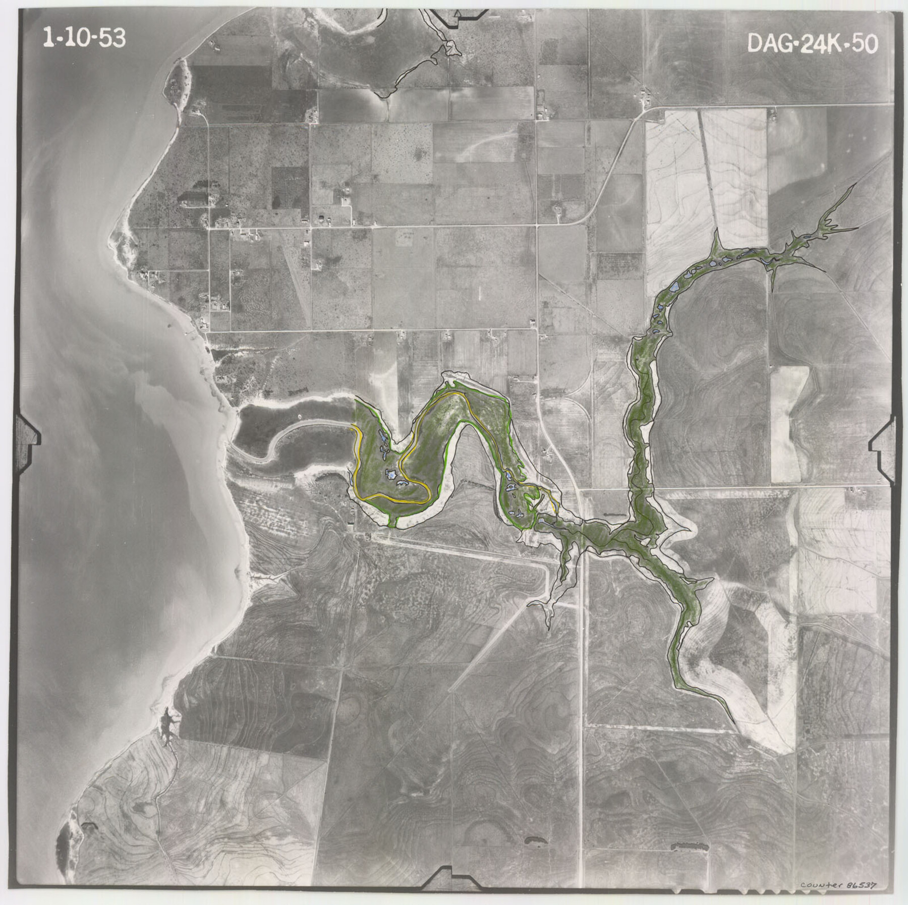
Flight Mission No. DAG-24K, Frame 50, Matagorda County
DAG-24K-50
-
Map/Doc
86537
-
Collection
General Map Collection
-
Object Dates
1953/1/10 (Creation Date)
-
People and Organizations
U. S. Department of Agriculture (Publisher)
-
Counties
Matagorda
-
Subjects
Aerial Photograph
-
Height x Width
16.0 x 16.0 inches
40.6 x 40.6 cm
-
Comments
Flown by Aero Exploration Company of Tulsa, Oklahoma.
Part of: General Map Collection
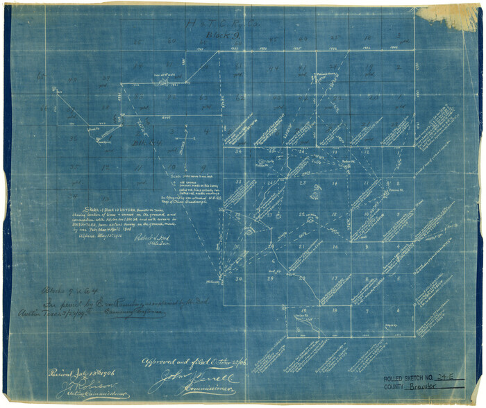
Brewster County Rolled Sketch 24E
Print $20.00
- Digital $50.00
Brewster County Rolled Sketch 24E
1906
Size 15.2 x 18.1 inches
Map/Doc 5212
Sabine Bank to East Bay including Heald Bank

Print $20.00
- Digital $50.00
Sabine Bank to East Bay including Heald Bank
1960
Size 45.1 x 34.3 inches
Map/Doc 69847
Chambers County Working Sketch 11

Print $20.00
- Digital $50.00
Chambers County Working Sketch 11
1952
Size 40.6 x 26.7 inches
Map/Doc 67994
Flight Mission No. CRE-2R, Frame 159, Jackson County

Print $20.00
- Digital $50.00
Flight Mission No. CRE-2R, Frame 159, Jackson County
1956
Size 18.5 x 22.2 inches
Map/Doc 85370
Grayson County Sketch File 25

Print $6.00
- Digital $50.00
Grayson County Sketch File 25
Size 8.4 x 7.1 inches
Map/Doc 24507
Dawson County Boundary File 3 (1)

Print $40.00
- Digital $50.00
Dawson County Boundary File 3 (1)
Size 11.1 x 35.8 inches
Map/Doc 52365
Hale County Boundary File 2

Print $4.00
- Digital $50.00
Hale County Boundary File 2
Size 10.9 x 8.8 inches
Map/Doc 54044
Irion County Working Sketch 3

Print $40.00
- Digital $50.00
Irion County Working Sketch 3
1921
Size 16.1 x 49.3 inches
Map/Doc 66412
Map of Jack County

Print $20.00
- Digital $50.00
Map of Jack County
Size 18.4 x 15.9 inches
Map/Doc 3702
Van Zandt County Sketch File 40

Print $4.00
- Digital $50.00
Van Zandt County Sketch File 40
Size 8.6 x 9.4 inches
Map/Doc 39486
Supreme Court of the United States, October Term, 1924, No. 13, Original - The State of Oklahoma, Complainant vs. The State of Texas, Defendant, The United States, Intervener

Print $20.00
- Digital $50.00
Supreme Court of the United States, October Term, 1924, No. 13, Original - The State of Oklahoma, Complainant vs. The State of Texas, Defendant, The United States, Intervener
1924
Size 33.7 x 33.7 inches
Map/Doc 75119

You may also like
Presidio County Sketch File 85

Print $6.00
- Digital $50.00
Presidio County Sketch File 85
1950
Size 14.3 x 8.9 inches
Map/Doc 34745
Flight Mission No. DQN-1K, Frame 124, Calhoun County

Print $20.00
- Digital $50.00
Flight Mission No. DQN-1K, Frame 124, Calhoun County
1953
Size 18.7 x 22.4 inches
Map/Doc 84190
Cottle County Working Sketch 1

Print $20.00
- Digital $50.00
Cottle County Working Sketch 1
1895
Size 27.0 x 21.7 inches
Map/Doc 68311
Reeves County Sketch File 9

Print $20.00
- Digital $50.00
Reeves County Sketch File 9
Size 46.3 x 38.2 inches
Map/Doc 10587
Pecos County Working Sketch 60

Print $20.00
- Digital $50.00
Pecos County Working Sketch 60
1950
Size 37.0 x 29.5 inches
Map/Doc 71532
[County School Land Leagues]
![90279, [County School Land Leagues], Twichell Survey Records](https://historictexasmaps.com/wmedia_w700/maps/90279-1.tif.jpg)
Print $20.00
- Digital $50.00
[County School Land Leagues]
1913
Size 21.1 x 27.7 inches
Map/Doc 90279
Kinney County Sketch File 16

Print $20.00
- Digital $50.00
Kinney County Sketch File 16
1887
Size 23.2 x 25.4 inches
Map/Doc 11941
[Cotton Belt, St. Louis Southwestern Railway of Texas, Alignment through Smith County]
![64384, [Cotton Belt, St. Louis Southwestern Railway of Texas, Alignment through Smith County], General Map Collection](https://historictexasmaps.com/wmedia_w700/maps/64384.tif.jpg)
Print $20.00
- Digital $50.00
[Cotton Belt, St. Louis Southwestern Railway of Texas, Alignment through Smith County]
1903
Size 21.4 x 29.9 inches
Map/Doc 64384

Map of Chicago, Rock Island & Texas Railway

Print $20.00
- Digital $50.00
Map of Chicago, Rock Island & Texas Railway
1892
Size 22.4 x 44.0 inches
Map/Doc 64443
Kendall County Working Sketch 1

Print $20.00
- Digital $50.00
Kendall County Working Sketch 1
1911
Size 18.8 x 17.6 inches
Map/Doc 66673
G. C. & S. F. Ry. Alinement [sic] and Right of Way Map of Dallas Branch, Johnson County, Texas
![64650, G. C. & S. F. Ry. Alinement [sic] and Right of Way Map of Dallas Branch, Johnson County, Texas, General Map Collection](https://historictexasmaps.com/wmedia_w700/maps/64650.tif.jpg)
Print $40.00
- Digital $50.00
G. C. & S. F. Ry. Alinement [sic] and Right of Way Map of Dallas Branch, Johnson County, Texas
1925
Size 38.0 x 125.2 inches
Map/Doc 64650