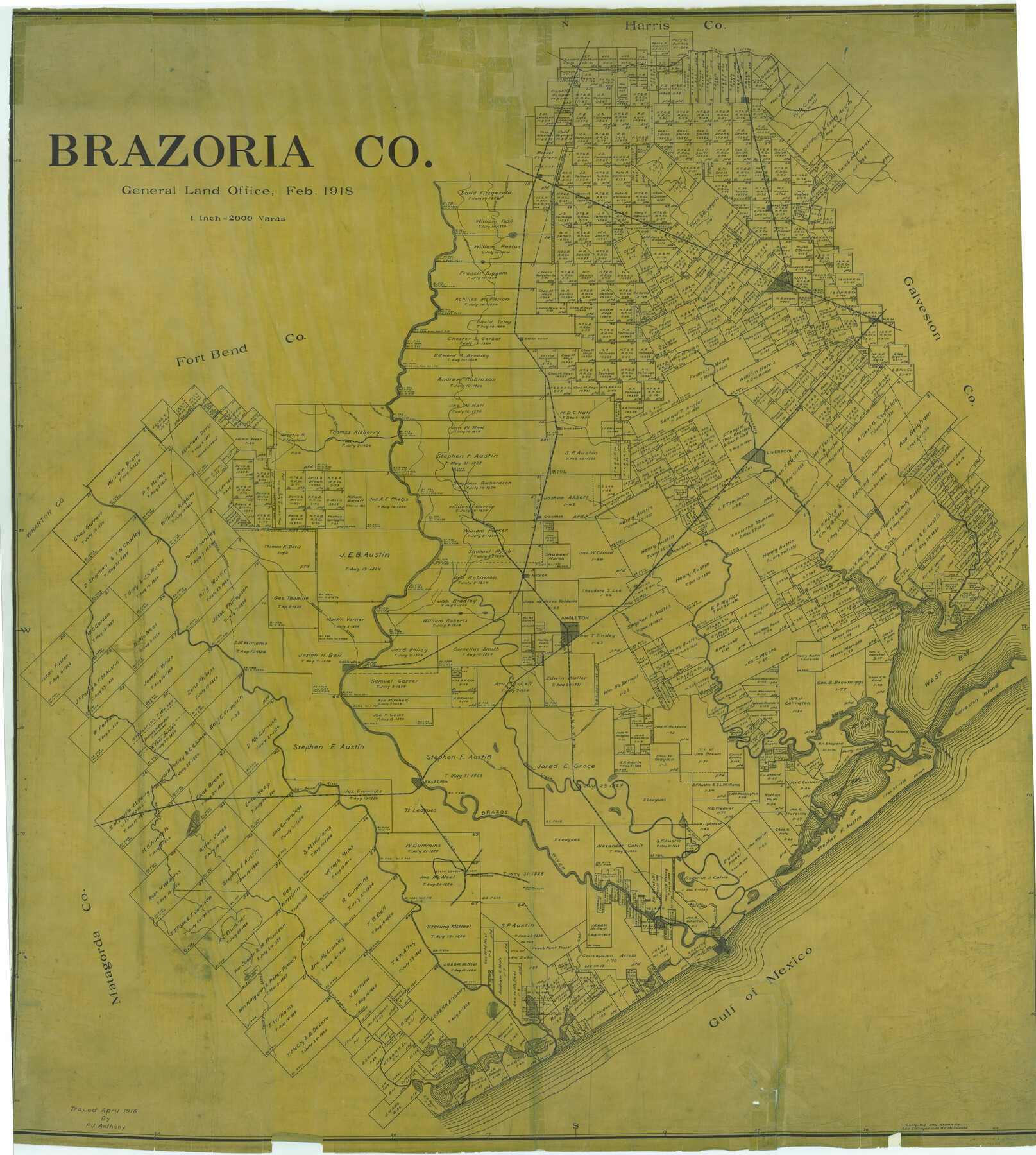
Brazoria Co.
-
Map/Doc
82067
-
Collection
General Map Collection
-
Object Dates
1918 (Creation Date)
-
People and Organizations
Texas General Land Office (Publisher)
Leo Ehlinger (Compiler)
Leo Ehlinger (Draftsman)
H.F. McDonald (Compiler)
H.F. McDonald (Draftsman)
-
Counties
Brazoria
-
Subjects
County
-
Height x Width
56.2 x 50.4 inches
142.7 x 128.0 cm
-
Comments
Traced by P. J. Anthony in 1918.
Part of: General Map Collection
Houston County Working Sketch 15

Print $20.00
- Digital $50.00
Houston County Working Sketch 15
1960
Size 26.3 x 20.0 inches
Map/Doc 66245
Webb County Sketch File 6-1

Print $6.00
- Digital $50.00
Webb County Sketch File 6-1
1877
Size 9.8 x 12.7 inches
Map/Doc 39737
Flight Mission No. BQR-4K, Frame 61, Brazoria County

Print $20.00
- Digital $50.00
Flight Mission No. BQR-4K, Frame 61, Brazoria County
1952
Size 18.7 x 22.5 inches
Map/Doc 83994
Roberts County Working Sketch 31

Print $20.00
- Digital $50.00
Roberts County Working Sketch 31
1978
Size 26.6 x 22.4 inches
Map/Doc 63557
El Paso County Working Sketch 8

Print $20.00
- Digital $50.00
El Paso County Working Sketch 8
1952
Size 23.9 x 22.5 inches
Map/Doc 69030
Stonewall County Rolled Sketch 32

Print $20.00
- Digital $50.00
Stonewall County Rolled Sketch 32
1951
Size 19.4 x 33.6 inches
Map/Doc 7876
Atascosa County
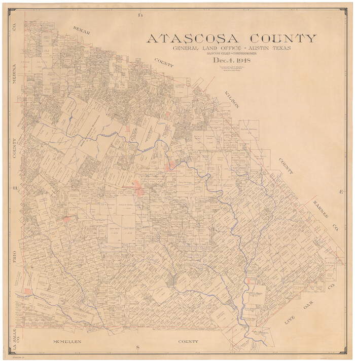
Print $20.00
- Digital $50.00
Atascosa County
1948
Size 46.6 x 45.4 inches
Map/Doc 73072
Burnet County Sketch File 38

Print $20.00
- Digital $50.00
Burnet County Sketch File 38
1935
Size 37.8 x 24.5 inches
Map/Doc 11027
Flight Mission No. BRA-8M, Frame 130, Jefferson County

Print $20.00
- Digital $50.00
Flight Mission No. BRA-8M, Frame 130, Jefferson County
1953
Size 15.8 x 15.7 inches
Map/Doc 85626
Flight Mission No. DAG-21K, Frame 128, Matagorda County

Print $20.00
- Digital $50.00
Flight Mission No. DAG-21K, Frame 128, Matagorda County
1952
Size 18.4 x 22.3 inches
Map/Doc 86454
Reagan County Rolled Sketch 19

Print $20.00
- Digital $50.00
Reagan County Rolled Sketch 19
1939
Size 24.0 x 20.5 inches
Map/Doc 7445

You may also like

Harris County Working Sketch 99

Print $20.00
- Digital $50.00
Harris County Working Sketch 99
1979
Size 46.6 x 30.1 inches
Map/Doc 65991
Roseborough Lake Sheet, Bowie County, Red River

Print $20.00
- Digital $50.00
Roseborough Lake Sheet, Bowie County, Red River
1934
Size 39.5 x 23.0 inches
Map/Doc 75273
Montgomery County Working Sketch 23

Print $20.00
- Digital $50.00
Montgomery County Working Sketch 23
1937
Size 42.5 x 37.2 inches
Map/Doc 71130
Loving County Working Sketch 19

Print $40.00
- Digital $50.00
Loving County Working Sketch 19
1978
Size 54.0 x 29.2 inches
Map/Doc 70653
Flight Mission No. CRE-2R, Frame 83, Jackson County

Print $20.00
- Digital $50.00
Flight Mission No. CRE-2R, Frame 83, Jackson County
1956
Size 18.6 x 22.3 inches
Map/Doc 85355
Flight Mission No. BQY-15M, Frame 14, Harris County

Print $20.00
- Digital $50.00
Flight Mission No. BQY-15M, Frame 14, Harris County
1953
Size 18.6 x 22.4 inches
Map/Doc 85312

Section 1, Block AX, Gaines County, Texas

Print $3.00
- Digital $50.00
Section 1, Block AX, Gaines County, Texas
1952
Size 11.1 x 13.1 inches
Map/Doc 92670
Outer Continental Shelf Leasing Maps (Louisiana Offshore Operations)

Print $20.00
- Digital $50.00
Outer Continental Shelf Leasing Maps (Louisiana Offshore Operations)
1955
Size 8.8 x 10.0 inches
Map/Doc 76091
Victoria County Sketch File 9

Print $8.00
- Digital $50.00
Victoria County Sketch File 9
1938
Size 14.3 x 8.8 inches
Map/Doc 39530
Flight Mission No. DIX-3P, Frame 60, Aransas County

Print $20.00
- Digital $50.00
Flight Mission No. DIX-3P, Frame 60, Aransas County
1956
Size 17.6 x 18.0 inches
Map/Doc 83762