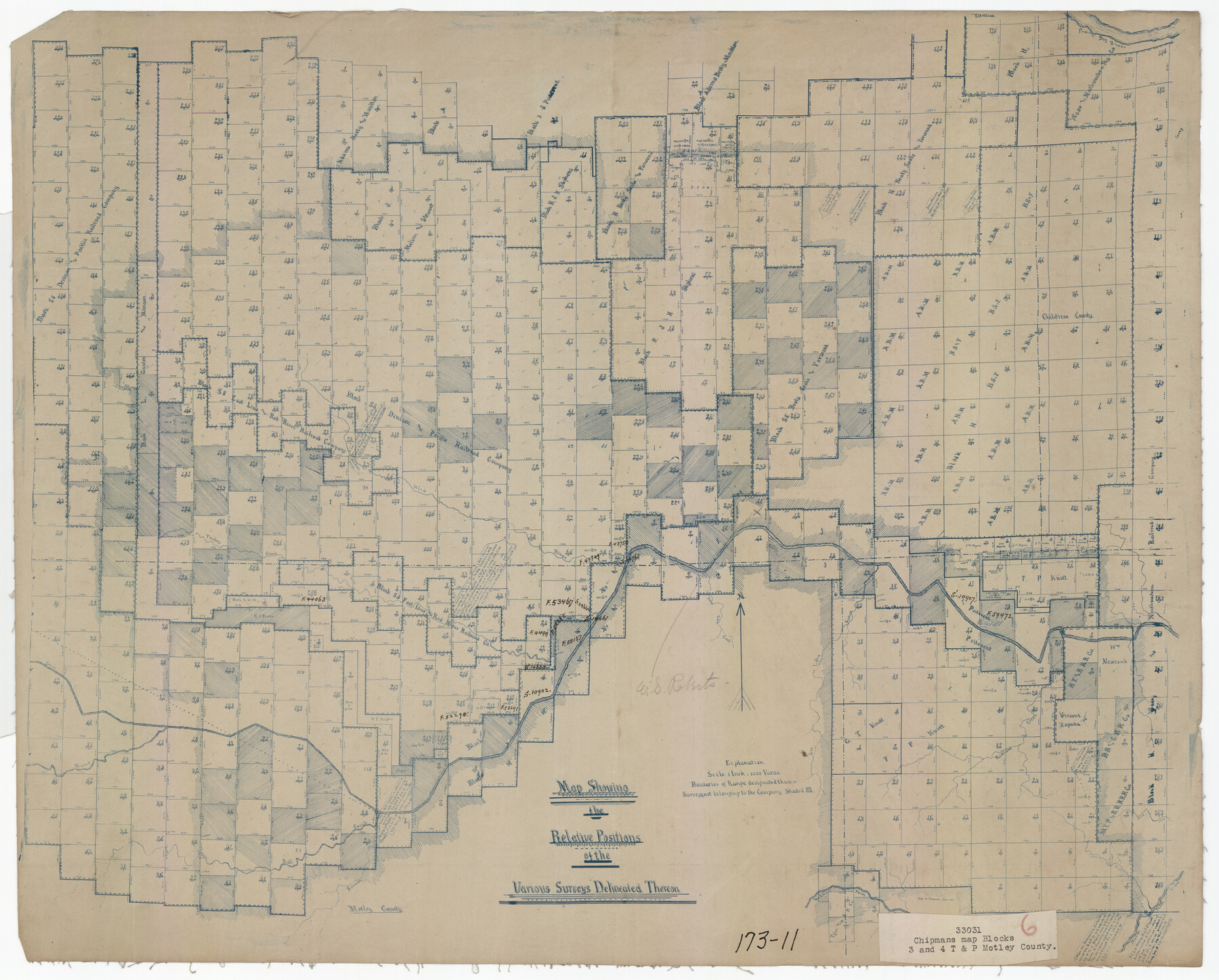
Map Showing the Relative Positions of the Various Surveys Delineated Thereon
173-11
-
Map/Doc
91500
-
Collection
Twichell Survey Records
-
Counties
Motley
-
Height x Width
23.0 x 18.6 inches
58.4 x 47.2 cm
Part of: Twichell Survey Records
Lane Estate Ranch, Gaines County, Texas

Print $20.00
- Digital $50.00
Lane Estate Ranch, Gaines County, Texas
1954
Size 9.1 x 20.8 inches
Map/Doc 92677
Map of Terry County

Print $20.00
- Digital $50.00
Map of Terry County
1917
Size 17.7 x 22.6 inches
Map/Doc 91874
[Sketch showing surveys in the north half of Potter County, Blocks 1, 6-T, 25, B-10, B-12, O-18, P and Mc, and H. & T. C., Block 44]
![91742, [Sketch showing surveys in the north half of Potter County, Blocks 1, 6-T, 25, B-10, B-12, O-18, P and Mc, and H. & T. C., Block 44], Twichell Survey Records](https://historictexasmaps.com/wmedia_w700/maps/91742-1.tif.jpg)
Print $20.00
- Digital $50.00
[Sketch showing surveys in the north half of Potter County, Blocks 1, 6-T, 25, B-10, B-12, O-18, P and Mc, and H. & T. C., Block 44]
Size 40.4 x 17.7 inches
Map/Doc 91742
Map of Hale County, Texas

Print $2.00
- Digital $50.00
Map of Hale County, Texas
Size 8.8 x 11.2 inches
Map/Doc 90697
[Part of Eastern Texas RR. Co. Block 1]
![91920, [Part of Eastern Texas RR. Co. Block 1], Twichell Survey Records](https://historictexasmaps.com/wmedia_w700/maps/91920-1.tif.jpg)
Print $20.00
- Digital $50.00
[Part of Eastern Texas RR. Co. Block 1]
Size 35.7 x 15.6 inches
Map/Doc 91920
[Sketch showing Blocks B-11, G and M-2 and 3, L, and 47, Sections 77-102]
![91733, [Sketch showing Blocks B-11, G and M-2 and 3, L, and 47, Sections 77-102], Twichell Survey Records](https://historictexasmaps.com/wmedia_w700/maps/91733-1.tif.jpg)
Print $20.00
- Digital $50.00
[Sketch showing Blocks B-11, G and M-2 and 3, L, and 47, Sections 77-102]
Size 25.4 x 18.8 inches
Map/Doc 91733

Gregg County School Land League 2

Print $20.00
- Digital $50.00
Gregg County School Land League 2
Size 16.4 x 17.7 inches
Map/Doc 90614
[Leagues 445, 465-468, Block B, Gregg County School Land Leagues 1 and 2]
![90532, [Leagues 445, 465-468, Block B, Gregg County School Land Leagues 1 and 2], Twichell Survey Records](https://historictexasmaps.com/wmedia_w700/maps/90532-1.tif.jpg)
Print $2.00
- Digital $50.00
[Leagues 445, 465-468, Block B, Gregg County School Land Leagues 1 and 2]
1902
Size 9.0 x 9.9 inches
Map/Doc 90532
[Sketch of Unknown Area in New Mexico]
![93027, [Sketch of Unknown Area in New Mexico], Twichell Survey Records](https://historictexasmaps.com/wmedia_w700/maps/93027-1.tif.jpg)
Print $40.00
- Digital $50.00
[Sketch of Unknown Area in New Mexico]
Size 50.6 x 37.1 inches
Map/Doc 93027
Lyons Subdivision North Part Block 79

Print $20.00
- Digital $50.00
Lyons Subdivision North Part Block 79
Size 19.6 x 24.5 inches
Map/Doc 92795

You may also like
Moore County Rolled Sketch 13
Print $20.00
- Digital $50.00
Moore County Rolled Sketch 13
1920
Size 25.8 x 33.3 inches
Map/Doc 6829
Smith County Rolled Sketch 6C

Print $20.00
- Digital $50.00
Smith County Rolled Sketch 6C
1943
Size 25.7 x 34.4 inches
Map/Doc 10701
[Sketch for Mineral Application 16777]
![65656, [Sketch for Mineral Application 16777], General Map Collection](https://historictexasmaps.com/wmedia_w700/maps/65656-1.tif.jpg)
Print $40.00
- Digital $50.00
[Sketch for Mineral Application 16777]
Size 80.3 x 20.0 inches
Map/Doc 65656
Willie Winn Tract

Print $20.00
- Digital $50.00
Willie Winn Tract
1903
Size 13.2 x 14.1 inches
Map/Doc 92286
Midland County Working Sketch 28

Print $20.00
- Digital $50.00
Midland County Working Sketch 28
1968
Size 29.7 x 31.7 inches
Map/Doc 71009
McLennan County Sketch File 20

Print $2.00
- Digital $50.00
McLennan County Sketch File 20
Size 8.0 x 9.1 inches
Map/Doc 31293
Flight Mission No. BRE-2P, Frame 103, Nueces County

Print $20.00
- Digital $50.00
Flight Mission No. BRE-2P, Frame 103, Nueces County
1956
Size 18.5 x 22.2 inches
Map/Doc 86788
Flight Mission No. BQY-4M, Frame 34, Harris County

Print $20.00
- Digital $50.00
Flight Mission No. BQY-4M, Frame 34, Harris County
1953
Size 18.6 x 22.4 inches
Map/Doc 85249
Blanco County Sketch File 22

Print $4.00
- Digital $50.00
Blanco County Sketch File 22
1884
Size 8.7 x 15.5 inches
Map/Doc 14604
Coryell County Sketch File 1

Print $13.00
- Digital $50.00
Coryell County Sketch File 1
1852
Size 15.9 x 11.0 inches
Map/Doc 19334
Presidio County Working Sketch 38

Print $20.00
- Digital $50.00
Presidio County Working Sketch 38
1948
Size 35.0 x 22.2 inches
Map/Doc 71715
Hood County Rolled Sketch 8

Print $20.00
- Digital $50.00
Hood County Rolled Sketch 8
2011
Size 19.3 x 24.5 inches
Map/Doc 90084