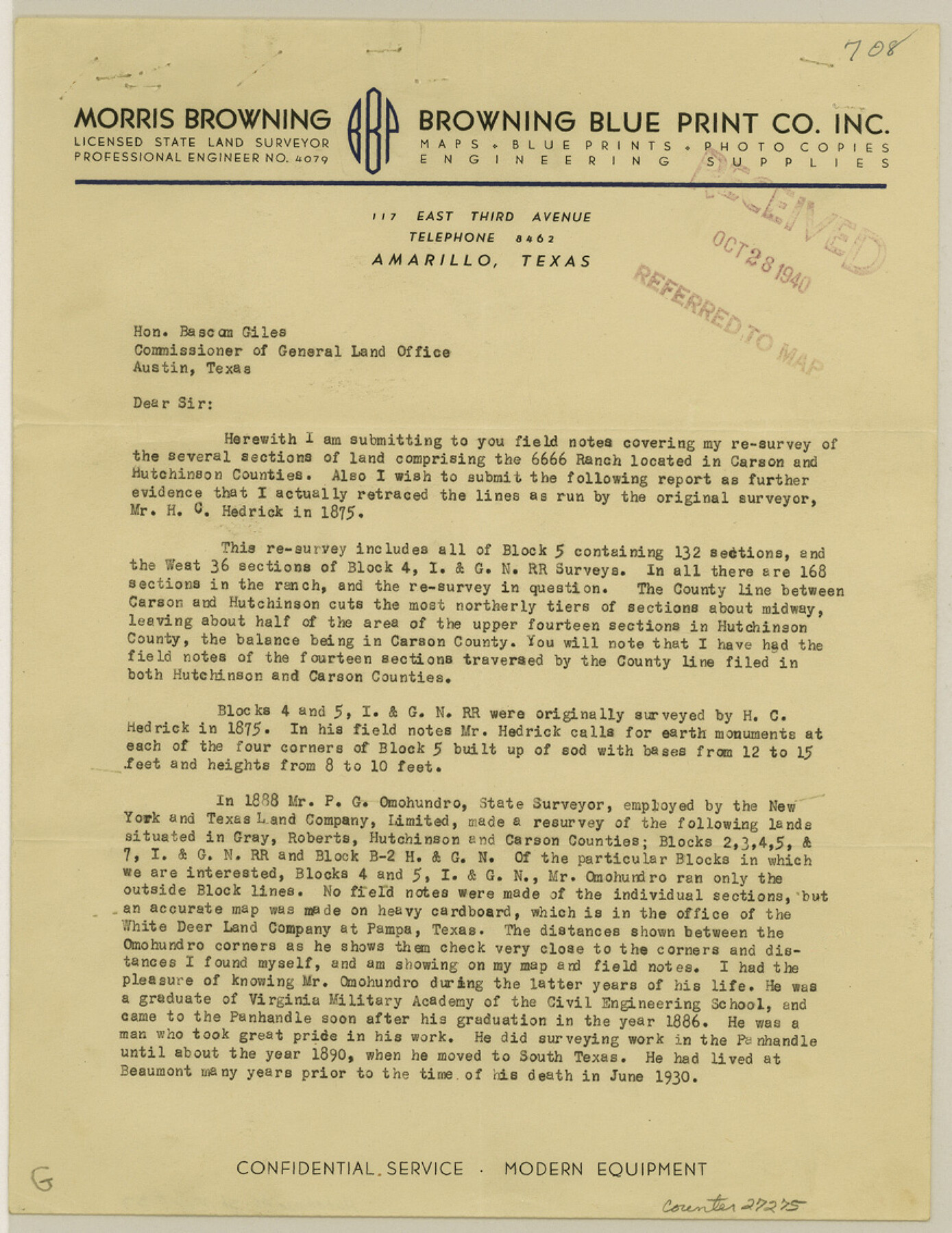
Hutchinson County Sketch File 37
[Surveyor's report of survey of all of Block 5 and west part of Block 4, I. & G. N. RR. Co.]
-
Map/Doc
27275
-
Collection
General Map Collection
-
Object Dates
10/28/1940 (File Date)
1875 (Survey Date)
1888 (Survey Date)
1927 (Survey Date)
1928 (Survey Date)
1890 (Survey Date)
-
People and Organizations
Morris Browning (Surveyor/Engineer)
H.C. Hedrick (Surveyor/Engineer)
P.G. Omohundro (Surveyor/Engineer)
T.D. Hobart (Surveyor/Engineer)
-
Counties
Hutchinson Carson
-
Subjects
Surveying Sketch File
-
Height x Width
11.3 x 8.8 inches
28.7 x 22.4 cm
-
Medium
paper, print
-
Features
6666 Ranch
Spring Creek
Bear Creek
Santa Fe Trail
Limestone Creek
Dixon Creek
Part of: General Map Collection
Foard County Sketch File 28

Print $20.00
- Digital $50.00
Foard County Sketch File 28
1883
Size 34.7 x 38.0 inches
Map/Doc 10452
The Great Texas Coastal Birding Trail, Central Texas Coast

The Great Texas Coastal Birding Trail, Central Texas Coast
Size 33.1 x 36.0 inches
Map/Doc 94339
San Jacinto County Rolled Sketch 7

Print $20.00
- Digital $50.00
San Jacinto County Rolled Sketch 7
1940
Size 23.6 x 28.8 inches
Map/Doc 7558

Dimmit County Sketch File 20

Print $6.00
- Digital $50.00
Dimmit County Sketch File 20
1884
Size 13.0 x 8.7 inches
Map/Doc 21100
Upton County Working Sketch 4

Print $20.00
- Digital $50.00
Upton County Working Sketch 4
Size 21.8 x 33.9 inches
Map/Doc 69500
Cameron County Rolled Sketch Z2

Print $20.00
- Digital $50.00
Cameron County Rolled Sketch Z2
1937
Size 23.7 x 40.9 inches
Map/Doc 5402
McCulloch County

Print $40.00
- Digital $50.00
McCulloch County
1904
Size 49.2 x 35.5 inches
Map/Doc 66921
A New Map of the United States of America

Print $20.00
- Digital $50.00
A New Map of the United States of America
1850
Size 17.7 x 27.8 inches
Map/Doc 89219
Flight Mission No. BRA-7M, Frame 207, Jefferson County

Print $20.00
- Digital $50.00
Flight Mission No. BRA-7M, Frame 207, Jefferson County
1953
Size 18.6 x 22.3 inches
Map/Doc 85575
Amistad International Reservoir on Rio Grande 62

Print $20.00
- Digital $50.00
Amistad International Reservoir on Rio Grande 62
1949
Size 28.2 x 39.6 inches
Map/Doc 73347
Travis County Working Sketch 1

Print $20.00
- Digital $50.00
Travis County Working Sketch 1
Size 30.9 x 17.6 inches
Map/Doc 69385
You may also like
Webb County Sketch File 8c

Print $4.00
- Digital $50.00
Webb County Sketch File 8c
1877
Size 12.7 x 8.2 inches
Map/Doc 39759
Presidio County Working Sketch 42

Print $40.00
- Digital $50.00
Presidio County Working Sketch 42
1948
Size 90.9 x 38.2 inches
Map/Doc 71719
Red River County Sketch File 17b

Print $4.00
- Digital $50.00
Red River County Sketch File 17b
1875
Size 12.9 x 8.1 inches
Map/Doc 35147

Liberty County Working Sketch 29

Print $20.00
- Digital $50.00
Liberty County Working Sketch 29
1943
Size 27.3 x 17.0 inches
Map/Doc 70488
Flight Mission No. CRC-4R, Frame 77, Chambers County

Print $20.00
- Digital $50.00
Flight Mission No. CRC-4R, Frame 77, Chambers County
1956
Size 18.9 x 22.5 inches
Map/Doc 84881
[Surveys in the Travis District along the Colorado River]
![120, [Surveys in the Travis District along the Colorado River], General Map Collection](https://historictexasmaps.com/wmedia_w700/maps/120-2.tif.jpg)
Print $3.00
- Digital $50.00
[Surveys in the Travis District along the Colorado River]
1841
Size 7.0 x 16.5 inches
Map/Doc 120
Trinity River, North Extension Bazzette Sheet

Print $20.00
- Digital $50.00
Trinity River, North Extension Bazzette Sheet
1925
Size 16.3 x 24.3 inches
Map/Doc 69691
Jefferson County Working Sketch 24

Print $20.00
- Digital $50.00
Jefferson County Working Sketch 24
1977
Size 28.4 x 44.5 inches
Map/Doc 66567
San Augustine and Sabine Counties

Print $20.00
- Digital $50.00
San Augustine and Sabine Counties
1881
Size 23.7 x 26.3 inches
Map/Doc 4012
Hamilton County Working Sketch 34

Print $20.00
- Digital $50.00
Hamilton County Working Sketch 34
1995
Size 37.7 x 39.8 inches
Map/Doc 63372
Refugio County Texas

Print $20.00
- Digital $50.00
Refugio County Texas
1896
Size 20.3 x 26.9 inches
Map/Doc 3985