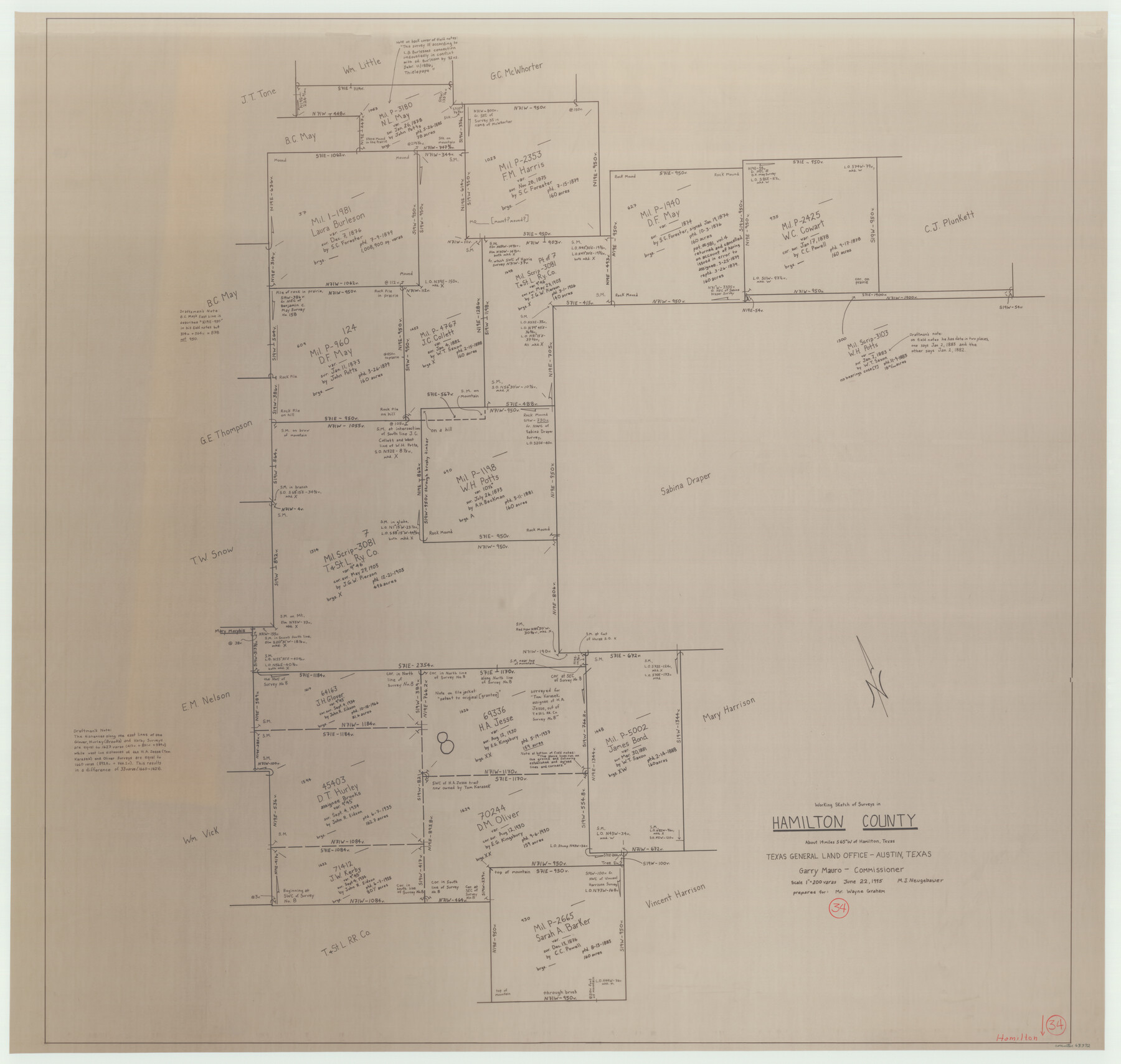
Hamilton County Working Sketch 34
-
Map/Doc
63372
-
Collection
General Map Collection
-
Object Dates
6/22/1995 (Creation Date)
-
People and Organizations
Mark Neugebauer (Draftsman)
-
Counties
Hamilton
-
Subjects
Surveying Working Sketch
-
Height x Width
37.7 x 39.8 inches
95.8 x 101.1 cm
-
Scale
1" = 200 varas
Part of: General Map Collection
Correct map of the Chicago, Burlington and Quincy Rail Road and its principal connecting lines

Print $20.00
- Digital $50.00
Correct map of the Chicago, Burlington and Quincy Rail Road and its principal connecting lines
1881
Size 27.7 x 38.6 inches
Map/Doc 93956
Terrell County Sketch File 36

Print $40.00
- Digital $50.00
Terrell County Sketch File 36
1958
Size 15.7 x 13.5 inches
Map/Doc 37998
Colorado River, Buecher State Park

Print $4.00
- Digital $50.00
Colorado River, Buecher State Park
1934
Size 20.8 x 11.6 inches
Map/Doc 65324
Morris County

Print $20.00
- Digital $50.00
Morris County
1906
Size 44.1 x 22.4 inches
Map/Doc 66944
La Salle County Working Sketch 7

Print $20.00
- Digital $50.00
La Salle County Working Sketch 7
1922
Size 35.0 x 36.5 inches
Map/Doc 70308
Kaufman County Sketch File 10a

Print $20.00
- Digital $50.00
Kaufman County Sketch File 10a
1871
Size 18.3 x 14.6 inches
Map/Doc 11906
Nueces County Sketch File 42

Print $24.00
- Digital $50.00
Nueces County Sketch File 42
1950
Size 11.0 x 8.6 inches
Map/Doc 32633
Lavaca County Working Sketch 3

Print $20.00
- Digital $50.00
Lavaca County Working Sketch 3
1928
Size 22.8 x 27.2 inches
Map/Doc 70356
Lamb County Boundary File 4

Print $16.00
- Digital $50.00
Lamb County Boundary File 4
Size 11.3 x 8.7 inches
Map/Doc 56084
Hartley County Working Sketch 5

Print $20.00
- Digital $50.00
Hartley County Working Sketch 5
1957
Size 46.3 x 28.9 inches
Map/Doc 66055
Kerr County Working Sketch 1

Print $20.00
- Digital $50.00
Kerr County Working Sketch 1
1900
Size 18.5 x 18.0 inches
Map/Doc 70032
Nueces River, Corpus Christi Sheet No. 6

Print $6.00
- Digital $50.00
Nueces River, Corpus Christi Sheet No. 6
1938
Size 31.3 x 31.0 inches
Map/Doc 65095
You may also like
Flight Mission No. CRE-2R, Frame 87, Jackson County

Print $20.00
- Digital $50.00
Flight Mission No. CRE-2R, Frame 87, Jackson County
1956
Size 18.5 x 22.3 inches
Map/Doc 85359
Reclamation & Navigation Map of Trinity River Flood Plain

Print $40.00
- Digital $50.00
Reclamation & Navigation Map of Trinity River Flood Plain
1930
Size 24.3 x 75.8 inches
Map/Doc 65178
Montague County Boundary File 2c

Print $44.00
- Digital $50.00
Montague County Boundary File 2c
Size 9.0 x 14.5 inches
Map/Doc 57419
Jack County Sketch File 26

Print $4.00
- Digital $50.00
Jack County Sketch File 26
1891
Size 8.7 x 9.3 inches
Map/Doc 27563
Kaufman County Boundary File 5

Print $37.00
- Digital $50.00
Kaufman County Boundary File 5
Size 13.4 x 8.7 inches
Map/Doc 55942
[PSL Blocks C31-C39]
![90790, [PSL Blocks C31-C39], Twichell Survey Records](https://historictexasmaps.com/wmedia_w700/maps/90790-1.tif.jpg)
Print $20.00
- Digital $50.00
[PSL Blocks C31-C39]
Size 43.1 x 9.8 inches
Map/Doc 90790
Reagan County Rolled Sketch 27

Print $40.00
- Digital $50.00
Reagan County Rolled Sketch 27
Size 66.0 x 47.2 inches
Map/Doc 9821
Duval County Boundary File 1d

Print $40.00
- Digital $50.00
Duval County Boundary File 1d
Size 6.6 x 47.7 inches
Map/Doc 52699
[Sketch showing Block M-20, Sections 9 through 46 and Block 22, Sections 1 through 12]
![91717, [Sketch showing Block M-20, Sections 9 through 46 and Block 22, Sections 1 through 12], Twichell Survey Records](https://historictexasmaps.com/wmedia_w700/maps/91717-1.tif.jpg)
Print $3.00
- Digital $50.00
[Sketch showing Block M-20, Sections 9 through 46 and Block 22, Sections 1 through 12]
Size 10.9 x 13.9 inches
Map/Doc 91717
Reagan County Sketch File 20

Print $4.00
- Digital $50.00
Reagan County Sketch File 20
Size 14.5 x 9.0 inches
Map/Doc 35011
Shackelford County Rolled Sketch 4A

Print $40.00
- Digital $50.00
Shackelford County Rolled Sketch 4A
1984
Size 35.2 x 48.7 inches
Map/Doc 9917
Lipscomb County Rolled Sketch 5

Print $40.00
- Digital $50.00
Lipscomb County Rolled Sketch 5
Size 9.8 x 62.5 inches
Map/Doc 10639