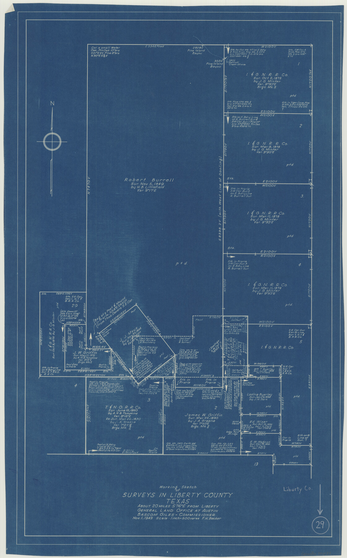
Liberty County Working Sketch 29
-
Map/Doc
70488
-
Collection
General Map Collection
-
Object Dates
11/1/1943 (Creation Date)
-
People and Organizations
F.H. Becker (Draftsman)
-
Counties
Liberty
-
Subjects
Surveying Working Sketch
-
Height x Width
27.3 x 17.0 inches
69.3 x 43.2 cm
-
Scale
1" = 500 varas
Part of: General Map Collection
Coryell County Sketch File 11

Print $4.00
- Digital $50.00
Coryell County Sketch File 11
Size 8.7 x 11.7 inches
Map/Doc 19364
Hockley County Boundary File 5

Print $42.00
- Digital $50.00
Hockley County Boundary File 5
Size 6.8 x 5.8 inches
Map/Doc 54829
Gray County Sketch File 1

Print $4.00
- Digital $50.00
Gray County Sketch File 1
1882
Size 10.4 x 7.2 inches
Map/Doc 24396
[Map of Polk County]
![4614, [Map of Polk County], General Map Collection](https://historictexasmaps.com/wmedia_w700/maps/4614-1.tif.jpg)
Print $20.00
- Digital $50.00
[Map of Polk County]
Size 21.7 x 25.8 inches
Map/Doc 4614
Instruccion Publica

Print $20.00
- Digital $50.00
Instruccion Publica
Size 26.0 x 34.2 inches
Map/Doc 96801
San Augustine County Working Sketch 16

Print $20.00
- Digital $50.00
San Augustine County Working Sketch 16
1962
Size 22.2 x 25.0 inches
Map/Doc 63704
Refugio County Sketch File 20

Print $8.00
- Digital $50.00
Refugio County Sketch File 20
Size 14.4 x 8.8 inches
Map/Doc 35276
Menard County Working Sketch 10

Print $20.00
- Digital $50.00
Menard County Working Sketch 10
1938
Size 21.8 x 18.5 inches
Map/Doc 70957
Gillespie County Rolled Sketch 7

Print $20.00
- Digital $50.00
Gillespie County Rolled Sketch 7
2008
Size 18.9 x 18.8 inches
Map/Doc 88818
Webb County Sketch File 12a

Print $20.00
- Digital $50.00
Webb County Sketch File 12a
1886
Size 20.7 x 31.4 inches
Map/Doc 12628
Clay County Sketch File 27

Print $20.00
- Digital $50.00
Clay County Sketch File 27
1900
Size 18.8 x 16.5 inches
Map/Doc 11089
Real County Working Sketch 21

Print $20.00
- Digital $50.00
Real County Working Sketch 21
1944
Size 24.8 x 35.7 inches
Map/Doc 71913
You may also like
Stonewall County Rolled Sketch 20

Print $40.00
- Digital $50.00
Stonewall County Rolled Sketch 20
Size 36.7 x 55.7 inches
Map/Doc 49129
Aransas County Rolled Sketch 1

Print $40.00
- Digital $50.00
Aransas County Rolled Sketch 1
1930
Size 12.5 x 50.0 inches
Map/Doc 8915
Geographical Observations on the Inner Margins of the Border and Coastal Reserves of Texas, 1824-1836

Geographical Observations on the Inner Margins of the Border and Coastal Reserves of Texas, 1824-1836
2022
Map/Doc 97131
[B. S. & F. Blk. M10, D. & S. E. RR. Co. Secs. 138 thru 149]
![90133, [B. S. & F. Blk. M10, D. & S. E. RR. Co. Secs. 138 thru 149], Twichell Survey Records](https://historictexasmaps.com/wmedia_w700/maps/90133-1.tif.jpg)
Print $20.00
- Digital $50.00
[B. S. & F. Blk. M10, D. & S. E. RR. Co. Secs. 138 thru 149]
Size 26.4 x 15.5 inches
Map/Doc 90133
Stieler Map of 1879

Print $4.00
- Digital $50.00
Stieler Map of 1879
1879
Size 28.9 x 23.0 inches
Map/Doc 76057
Erath County Rolled Sketch 3A

Print $20.00
- Digital $50.00
Erath County Rolled Sketch 3A
1982
Size 21.7 x 27.8 inches
Map/Doc 5865
Hudspeth County Working Sketch 10

Print $20.00
- Digital $50.00
Hudspeth County Working Sketch 10
1941
Size 16.0 x 17.1 inches
Map/Doc 66291
Tyler County Rolled Sketch 6

Print $40.00
- Digital $50.00
Tyler County Rolled Sketch 6
1956
Size 76.1 x 43.2 inches
Map/Doc 10029
Topographical Map of the Rio Grande, Sheet No. 16

Print $20.00
- Digital $50.00
Topographical Map of the Rio Grande, Sheet No. 16
1912
Map/Doc 89540
[North and West Line of Gray County, North Line of Wheeler County]
![89943, [North and West Line of Gray County, North Line of Wheeler County], Twichell Survey Records](https://historictexasmaps.com/wmedia_w700/maps/89943-1.tif.jpg)
Print $40.00
- Digital $50.00
[North and West Line of Gray County, North Line of Wheeler County]
Size 43.4 x 71.6 inches
Map/Doc 89943
Map of Sections 1-60 Block 46, H. & T. C. RR. Co. Survey according to courses and distances - Maddox survey

Print $40.00
- Digital $50.00
Map of Sections 1-60 Block 46, H. & T. C. RR. Co. Survey according to courses and distances - Maddox survey
Size 75.6 x 20.2 inches
Map/Doc 93129
Anderson County Working Sketch 36

Print $20.00
- Digital $50.00
Anderson County Working Sketch 36
1984
Size 36.3 x 45.6 inches
Map/Doc 67036