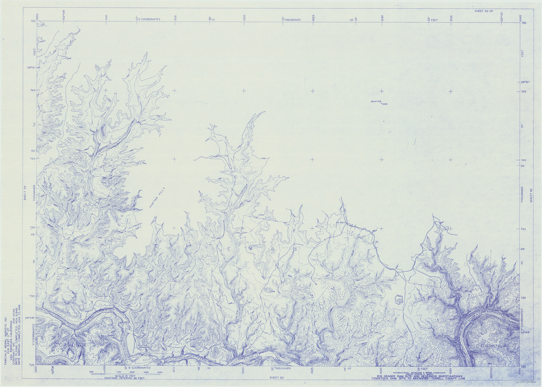
Amistad International Reservoir on Rio Grande 62
Rio Grande Dam Site and Reservoir Investigations
-
Map/Doc
73347
-
Collection
General Map Collection
-
Object Dates
1949/6/25 (Creation Date)
-
People and Organizations
International Boundary and Water Commission (Publisher)
Fairchild Aerial Surveys Inc. (Surveyor/Engineer)
-
Counties
Terrell
-
Subjects
River Surveys Texas Boundaries Topographic
-
Height x Width
28.2 x 39.6 inches
71.6 x 100.6 cm
-
Medium
blueline
-
Comments
Comstock Dam site to Brewster-Terrell County line.
Part of: General Map Collection
McCulloch County Rolled Sketch 1

Print $20.00
- Digital $50.00
McCulloch County Rolled Sketch 1
Size 44.4 x 36.9 inches
Map/Doc 9495

Pecos County Sketch File 43

Print $20.00
- Digital $50.00
Pecos County Sketch File 43
Size 16.1 x 30.4 inches
Map/Doc 12178
Brazoria County Working Sketch 5

Print $20.00
- Digital $50.00
Brazoria County Working Sketch 5
1921
Size 15.1 x 17.1 inches
Map/Doc 67490
Maverick County Working Sketch 1

Print $20.00
- Digital $50.00
Maverick County Working Sketch 1
1906
Size 11.5 x 11.1 inches
Map/Doc 70893
Mills County Sketch File 1

Print $8.00
- Digital $50.00
Mills County Sketch File 1
1853
Size 11.6 x 12.7 inches
Map/Doc 31641
[Surveys along the Brazos River]
![261, [Surveys along the Brazos River], General Map Collection](https://historictexasmaps.com/wmedia_w700/maps/261.tif.jpg)
Print $2.00
- Digital $50.00
[Surveys along the Brazos River]
1847
Size 12.1 x 8.4 inches
Map/Doc 261
Henderson County Sketch File 19

Print $4.00
- Digital $50.00
Henderson County Sketch File 19
Size 9.1 x 8.9 inches
Map/Doc 26363
Flight Mission No. CGI-4N, Frame 159, Cameron County

Print $20.00
- Digital $50.00
Flight Mission No. CGI-4N, Frame 159, Cameron County
1955
Size 18.7 x 22.2 inches
Map/Doc 84667
Presidio County Sketch File 83

Print $8.00
- Digital $50.00
Presidio County Sketch File 83
1949
Size 11.3 x 8.8 inches
Map/Doc 34722
Hudspeth County Sketch File 9

Print $8.00
- Digital $50.00
Hudspeth County Sketch File 9
1900
Size 11.3 x 8.8 inches
Map/Doc 26895
Val Verde County Rolled Sketch 53

Print $20.00
- Digital $50.00
Val Verde County Rolled Sketch 53
1937
Size 32.0 x 25.0 inches
Map/Doc 8122
You may also like
San Patricio County Working Sketch 1
Print $20.00
- Digital $50.00
San Patricio County Working Sketch 1
Size 25.2 x 26.2 inches
Map/Doc 63763
Flight Mission No. BQY-15M, Frame 19, Harris County

Print $20.00
- Digital $50.00
Flight Mission No. BQY-15M, Frame 19, Harris County
1953
Size 18.6 x 22.4 inches
Map/Doc 85317
[T. & N. O. R.R. Jefferson Co. North]
![64055, [T. & N. O. R.R. Jefferson Co. North], General Map Collection](https://historictexasmaps.com/wmedia_w700/maps/64055.tif.jpg)
Print $20.00
- Digital $50.00
[T. & N. O. R.R. Jefferson Co. North]
Size 13.4 x 33.4 inches
Map/Doc 64055
Travis County Sketch File 26

Print $4.00
- Digital $50.00
Travis County Sketch File 26
1876
Size 12.9 x 8.5 inches
Map/Doc 38336
Harris County Sketch File 69b

Print $20.00
- Digital $50.00
Harris County Sketch File 69b
1938
Size 25.3 x 18.9 inches
Map/Doc 11664
Taylor County, Texas

Print $20.00
- Digital $50.00
Taylor County, Texas
1890
Size 28.7 x 21.6 inches
Map/Doc 574
Jim Hogg County Rolled Sketch 4

Print $20.00
- Digital $50.00
Jim Hogg County Rolled Sketch 4
Size 17.0 x 30.5 inches
Map/Doc 6440
[Surveys along the Leon River and Plum Creek]
![255, [Surveys along the Leon River and Plum Creek], General Map Collection](https://historictexasmaps.com/wmedia_w700/maps/255.tif.jpg)
Print $2.00
- Digital $50.00
[Surveys along the Leon River and Plum Creek]
1846
Size 11.7 x 7.6 inches
Map/Doc 255
[H. & G. N. RR. Co. Blks. 1 & 2]
![89771, [H. & G. N. RR. Co. Blks. 1 & 2], Twichell Survey Records](https://historictexasmaps.com/wmedia_w700/maps/89771-1.tif.jpg)
Print $20.00
- Digital $50.00
[H. & G. N. RR. Co. Blks. 1 & 2]
Size 40.9 x 46.6 inches
Map/Doc 89771
Map of the World on a Globular Projection to illustrate Olney's school geography

Print $20.00
- Digital $50.00
Map of the World on a Globular Projection to illustrate Olney's school geography
1844
Size 12.1 x 19.0 inches
Map/Doc 93535
United States - Gulf Coast - Galveston to Rio Grande

Print $20.00
- Digital $50.00
United States - Gulf Coast - Galveston to Rio Grande
1919
Size 26.5 x 18.2 inches
Map/Doc 72747
Brazos River Conservation and Reclamation District Official Boundary Line Survey, Parmer County

Print $20.00
- Digital $50.00
Brazos River Conservation and Reclamation District Official Boundary Line Survey, Parmer County
Size 24.5 x 16.9 inches
Map/Doc 91658