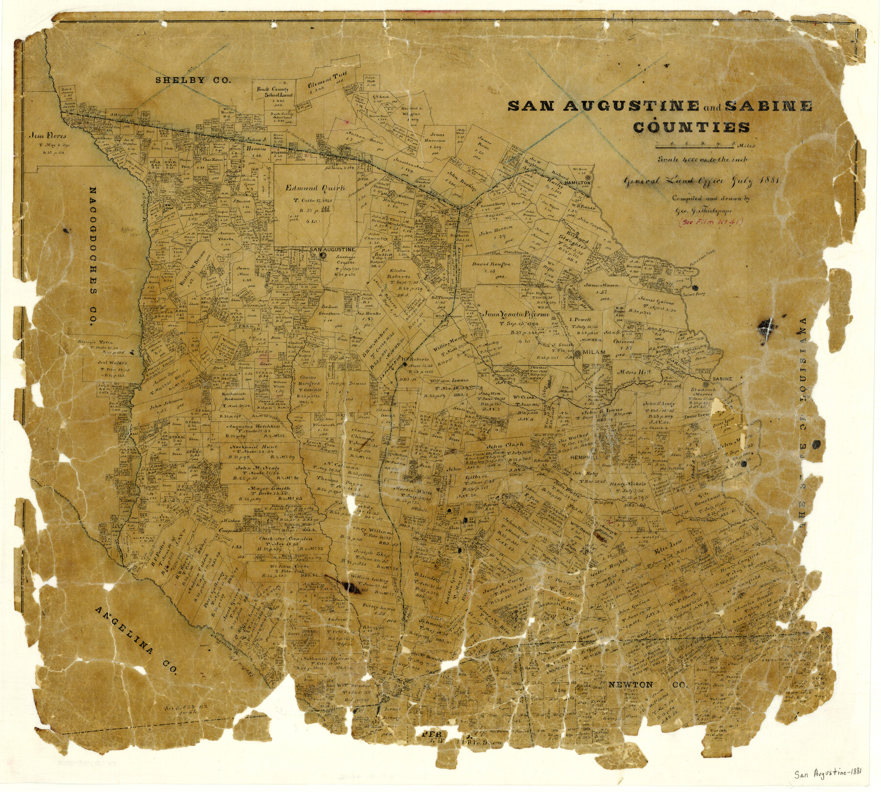
San Augustine and Sabine Counties
-
Map/Doc
4012
-
Collection
General Map Collection
-
Object Dates
1881 (Creation Date)
-
People and Organizations
Texas General Land Office (Publisher)
George J. Thielepape (Compiler)
George J. Thielepape (Draftsman)
-
Counties
San Augustine Sabine
-
Subjects
County
-
Height x Width
23.7 x 26.3 inches
60.2 x 66.8 cm
-
Features
Baer Creek
Sandy Creek
Six Miles Creek
Walnut Creek
Rush Creek
Bear Creek
Comesetana Creek
Angelina River
Clear Creek
Devil's Ford Creek
Rock Creek
Richland Creek
Nuckles Creek
Big Rock Creek
Sabine River
Archoso [Creek]
Speer Creek
Teabo Bayou
Watto Creek
Gallion Creek
Deer Creek
Harvey Bayou
Cowesetuna Creek
Magnolia Creek
Buzzard Creek
Rusk Creek
Bluchor Creek
Milam
Attoyac River
Hamilton
Patroon Bayou
Paterson's Ferry
Gaines Ferry
Palo Gaucho Bayou
San Augustine
Bonado Bayou
Caney Creek
Tiger Creek
Sabanillo Creek
Boregus Creek
Boregus Fork of Palo Gaucho Bayou
Running Fork [of Patroon Bayou]
Lows Ferry
Sabine
Ayish Bayou
Chaquapin Bayou
Cany Bayou
Turkey Creek
Dogwood Bayou
Arenos Creek
Chiamon Bayou
Bridge Creek
Marian Creek
Housing Bayou
Part of: General Map Collection
A Compleat Map of the West Indies, containing the Coasts of Florida, Louisiana, New Spain, and Terra Firma: with all the Islands

Print $20.00
- Digital $50.00
A Compleat Map of the West Indies, containing the Coasts of Florida, Louisiana, New Spain, and Terra Firma: with all the Islands
1774
Size 13.9 x 19.0 inches
Map/Doc 97400
La Salle County Sketch File 6

Print $7.00
- Digital $50.00
La Salle County Sketch File 6
1875
Size 10.0 x 8.0 inches
Map/Doc 29453
No. 3 Chart of Channel connecting Corpus Christi Bay with Aransas Bay, Texas

Print $20.00
- Digital $50.00
No. 3 Chart of Channel connecting Corpus Christi Bay with Aransas Bay, Texas
1878
Size 18.4 x 28.0 inches
Map/Doc 72771
Ector County Working Sketch 31

Print $40.00
- Digital $50.00
Ector County Working Sketch 31
1980
Size 36.0 x 51.0 inches
Map/Doc 68874
Connected Map of Austin's Colony (1892 tracing)

Print $40.00
- Digital $50.00
Connected Map of Austin's Colony (1892 tracing)
1837
Size 90.8 x 46.5 inches
Map/Doc 93359
Webb County Boundary File 1

Print $16.00
- Digital $50.00
Webb County Boundary File 1
Size 7.2 x 8.9 inches
Map/Doc 59695
Haskell County

Print $20.00
- Digital $50.00
Haskell County
1873
Size 20.1 x 24.2 inches
Map/Doc 3642
Galveston County NRC Article 33.136 Sketch 29

Print $21.00
- Digital $50.00
Galveston County NRC Article 33.136 Sketch 29
2005
Size 22.4 x 31.9 inches
Map/Doc 83282
Wood County Working Sketch 3

Print $2.00
- Digital $50.00
Wood County Working Sketch 3
1916
Size 9.8 x 8.4 inches
Map/Doc 62003
Rand, McNally and Co.'s Texas and Indian Territory

Print $20.00
- Digital $50.00
Rand, McNally and Co.'s Texas and Indian Territory
1883
Size 24.3 x 18.6 inches
Map/Doc 4331
[Sketch for Mineral Application 13439 - Bed Lost Lake, Walle Merritt]
![65578, [Sketch for Mineral Application 13439 - Bed Lost Lake, Walle Merritt], General Map Collection](https://historictexasmaps.com/wmedia_w700/maps/65578.tif.jpg)
Print $20.00
- Digital $50.00
[Sketch for Mineral Application 13439 - Bed Lost Lake, Walle Merritt]
1925
Size 31.0 x 29.6 inches
Map/Doc 65578
Morris County Rolled Sketch 2A

Print $20.00
- Digital $50.00
Morris County Rolled Sketch 2A
Size 24.2 x 19.1 inches
Map/Doc 10243
You may also like
Railroad Track Map, H&TCRRCo., Falls County, Texas

Print $4.00
- Digital $50.00
Railroad Track Map, H&TCRRCo., Falls County, Texas
1918
Size 11.4 x 18.7 inches
Map/Doc 62851
Coke County Rolled Sketch 15A

Print $20.00
- Digital $50.00
Coke County Rolled Sketch 15A
1949
Size 43.8 x 44.3 inches
Map/Doc 8629
General Highway Map, Sabine County, Texas

Print $20.00
General Highway Map, Sabine County, Texas
1940
Size 24.7 x 18.3 inches
Map/Doc 79233
Red River County Working Sketch 81-2

Print $20.00
- Digital $50.00
Red River County Working Sketch 81-2
1987
Size 14.6 x 18.6 inches
Map/Doc 72065
Hudspeth County Sketch File 42

Print $12.00
- Digital $50.00
Hudspeth County Sketch File 42
1982
Size 14.2 x 8.7 inches
Map/Doc 27016
[Surveys in the Bexar District along the Guadalupe River]
![124, [Surveys in the Bexar District along the Guadalupe River], General Map Collection](https://historictexasmaps.com/wmedia_w700/maps/124.tif.jpg)
Print $3.00
- Digital $50.00
[Surveys in the Bexar District along the Guadalupe River]
1841
Size 17.2 x 10.8 inches
Map/Doc 124
Gaines County Sketch File 13

Print $40.00
- Digital $50.00
Gaines County Sketch File 13
1954
Size 8.9 x 20.4 inches
Map/Doc 23200
[I. & G. N. Block 1]
![91592, [I. & G. N. Block 1], Twichell Survey Records](https://historictexasmaps.com/wmedia_w700/maps/91592-1.tif.jpg)
Print $20.00
- Digital $50.00
[I. & G. N. Block 1]
Size 17.2 x 18.1 inches
Map/Doc 91592
Flight Mission No. CUG-2P, Frame 76, Kleberg County

Print $20.00
- Digital $50.00
Flight Mission No. CUG-2P, Frame 76, Kleberg County
1956
Size 18.4 x 22.1 inches
Map/Doc 86208
Edwards County Rolled Sketch 25

Print $20.00
- Digital $50.00
Edwards County Rolled Sketch 25
1955
Size 30.2 x 35.5 inches
Map/Doc 5811
Wharton County Working Sketch 18

Print $20.00
- Digital $50.00
Wharton County Working Sketch 18
1948
Size 19.3 x 17.0 inches
Map/Doc 72482
Schleicher County Rolled Sketch 18

Print $20.00
- Digital $50.00
Schleicher County Rolled Sketch 18
Size 31.6 x 27.9 inches
Map/Doc 7760