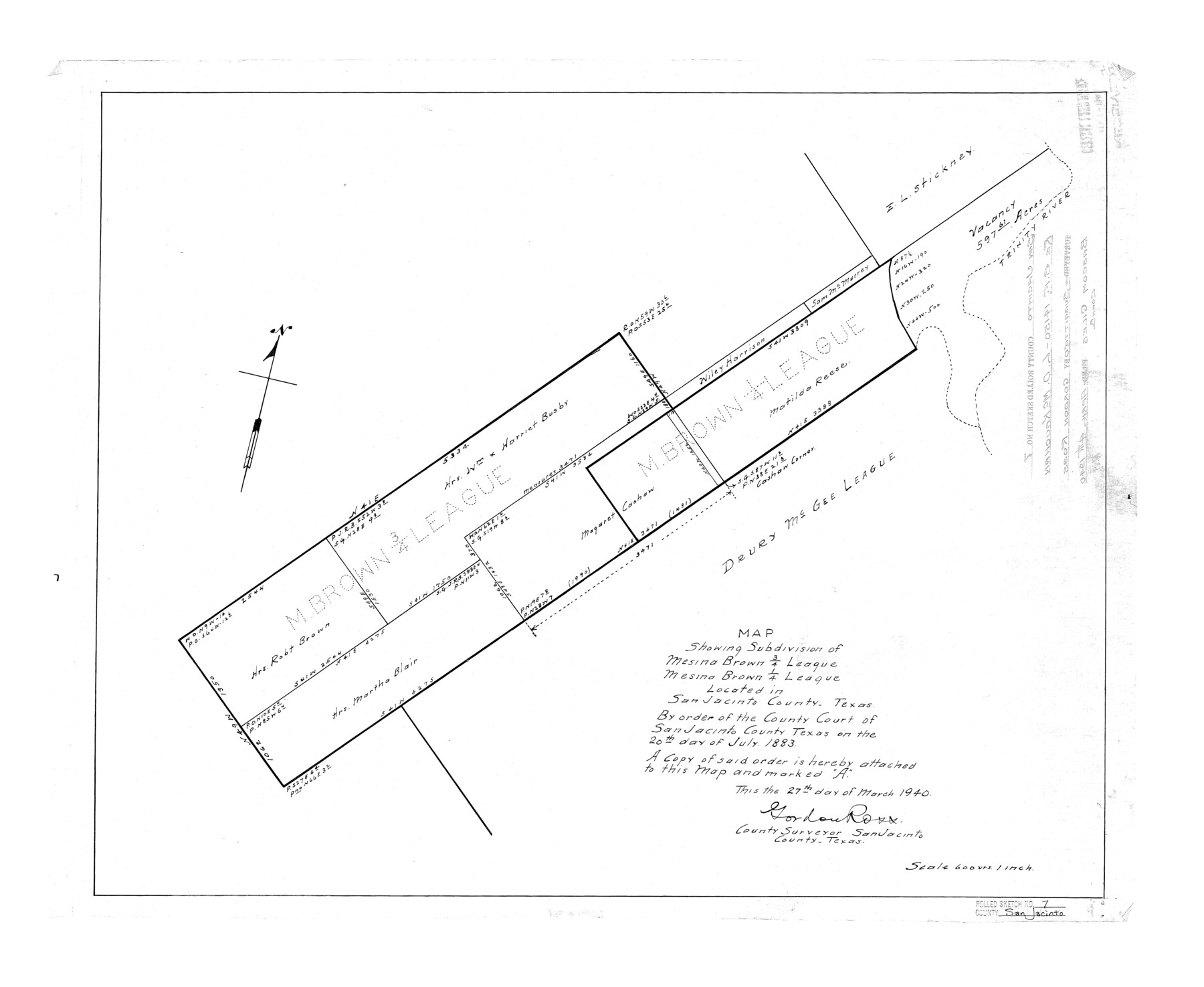
San Jacinto County Rolled Sketch 7
Map showing subdivision of Mesina Brown 3/4 league, Mesina Brown 1/4 league located in San Jacinto County, Texas
-
Map/Doc
7558
-
Collection
General Map Collection
-
Object Dates
1940/3/27 (Creation Date)
1940/4/4 (File Date)
-
People and Organizations
Gordon Ross (Surveyor/Engineer)
-
Counties
San Jacinto
-
Subjects
Surveying Rolled Sketch
-
Height x Width
23.6 x 28.8 inches
59.9 x 73.2 cm
-
Scale
1" = 600 varas
Part of: General Map Collection
Palo Pinto County Rolled Sketch 9

Print $40.00
- Digital $50.00
Palo Pinto County Rolled Sketch 9
Size 78.0 x 30.9 inches
Map/Doc 9675
Brazoria County Rolled Sketch 47

Print $20.00
- Digital $50.00
Brazoria County Rolled Sketch 47
1951
Size 17.4 x 22.6 inches
Map/Doc 5180
University Lands Blocks 34 to 37, Terrell County

Print $20.00
- Digital $50.00
University Lands Blocks 34 to 37, Terrell County
1938
Size 32.8 x 40.0 inches
Map/Doc 2451

Flight Mission No. DIX-6P, Frame 190, Aransas County

Print $20.00
- Digital $50.00
Flight Mission No. DIX-6P, Frame 190, Aransas County
1956
Size 18.8 x 22.7 inches
Map/Doc 83852
Hill County Boundary File 1a

Print $40.00
- Digital $50.00
Hill County Boundary File 1a
Size 18.4 x 23.3 inches
Map/Doc 54732
Atascosa County Working Sketch 38

Print $40.00
- Digital $50.00
Atascosa County Working Sketch 38
2011
Size 31.1 x 60.6 inches
Map/Doc 90031
Roberts County Working Sketch 1

Print $20.00
- Digital $50.00
Roberts County Working Sketch 1
1922
Size 17.6 x 17.7 inches
Map/Doc 63527
Kent County Working Sketch 20

Print $40.00
- Digital $50.00
Kent County Working Sketch 20
1980
Size 50.7 x 44.1 inches
Map/Doc 70027
Wise County Sketch File 50

Print $20.00
- Digital $50.00
Wise County Sketch File 50
1895
Size 23.7 x 29.9 inches
Map/Doc 12703
Kenedy County Working Sketch 1

Print $20.00
- Digital $50.00
Kenedy County Working Sketch 1
Size 31.1 x 22.0 inches
Map/Doc 70002
Brewster County Working Sketch 70

Print $20.00
- Digital $50.00
Brewster County Working Sketch 70
1961
Size 30.5 x 44.0 inches
Map/Doc 67671
You may also like
Wharton County Sketch File 15

Print $20.00
- Digital $50.00
Wharton County Sketch File 15
Size 18.2 x 21.1 inches
Map/Doc 12665
Bee County Boundary File 6

Print $4.00
- Digital $50.00
Bee County Boundary File 6
Size 10.4 x 7.9 inches
Map/Doc 50458
Sabine County Sketch File 2

Print $4.00
Sabine County Sketch File 2
Size 10.0 x 7.9 inches
Map/Doc 35602
[De Loches County School Land]
![91198, [De Loches County School Land], Twichell Survey Records](https://historictexasmaps.com/wmedia_w700/maps/91198-1.tif.jpg)
Print $20.00
- Digital $50.00
[De Loches County School Land]
Size 20.4 x 35.2 inches
Map/Doc 91198
Angelina County Working Sketch 55

Print $20.00
- Digital $50.00
Angelina County Working Sketch 55
1989
Size 33.7 x 30.0 inches
Map/Doc 67139
Webb County Boundary File 1a

Print $50.00
- Digital $50.00
Webb County Boundary File 1a
Size 14.3 x 9.0 inches
Map/Doc 59703
Cochran County Working Sketch 4

Print $20.00
- Digital $50.00
Cochran County Working Sketch 4
1984
Size 37.7 x 24.8 inches
Map/Doc 68015
Sketch H Showing the progress of the Survey in Section No. 8

Print $20.00
- Digital $50.00
Sketch H Showing the progress of the Survey in Section No. 8
1846
Size 17.1 x 20.6 inches
Map/Doc 97222
Colorado River Project - Texas, Marshall Ford Dam right of way survey

Print $20.00
- Digital $50.00
Colorado River Project - Texas, Marshall Ford Dam right of way survey
1937
Size 22.1 x 42.0 inches
Map/Doc 3151
Right of Way and Track Map Houston & Texas Central R.R. operated by the T. & N.O. R.R. Co., Austin Branch

Print $40.00
- Digital $50.00
Right of Way and Track Map Houston & Texas Central R.R. operated by the T. & N.O. R.R. Co., Austin Branch
1918
Size 25.6 x 57.8 inches
Map/Doc 64555
Jones County Rolled Sketch 1

Print $20.00
- Digital $50.00
Jones County Rolled Sketch 1
1957
Size 26.1 x 28.3 inches
Map/Doc 6450
[I. & G. N. Block 1]
![91606, [I. & G. N. Block 1], Twichell Survey Records](https://historictexasmaps.com/wmedia_w700/maps/91606-1.tif.jpg)
Print $20.00
- Digital $50.00
[I. & G. N. Block 1]
Size 34.0 x 30.2 inches
Map/Doc 91606