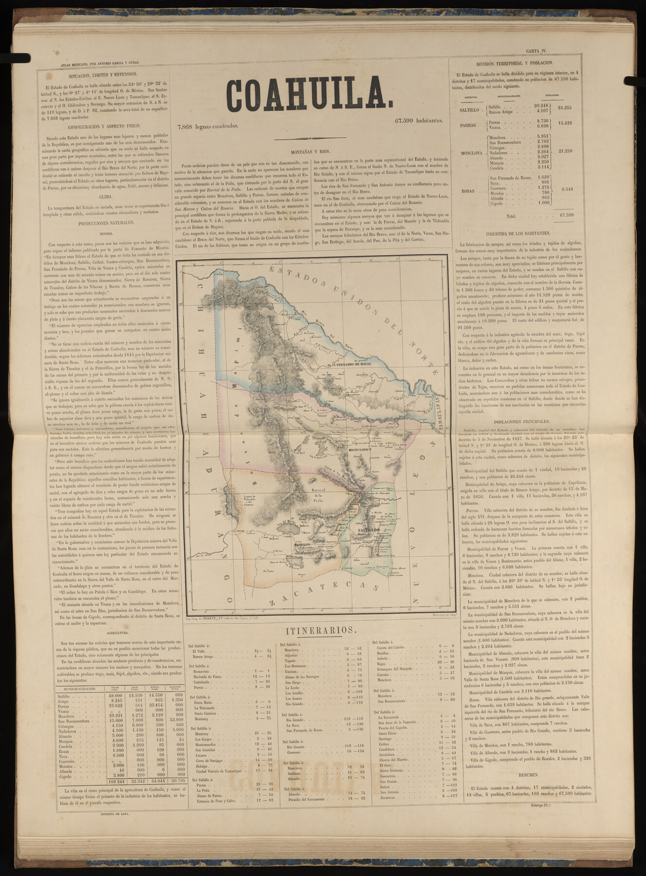
Coahuila
-
Map/Doc
96985
-
Collection
General Map Collection
-
Object Dates
1858 (Publication Date)
-
People and Organizations
Antonio García y Cubas (Cartographer)
-
Subjects
Atlas Mexico
-
Height x Width
31.2 x 23.0 inches
79.3 x 58.4 cm
-
Medium
paper, etching/engraving/lithograph
-
Comments
Map 4 of 32 from "Atlas Geografico, Estadistico e Historico de la Republica Mexicana" (95689)
Related maps
Atlas Geográfico, Estadístico é Histórico de la República Mexicana

Atlas Geográfico, Estadístico é Histórico de la República Mexicana
Map/Doc 95689
Part of: General Map Collection
Wilson County Boundary File 5a

Print $20.00
- Digital $50.00
Wilson County Boundary File 5a
Size 12.0 x 28.0 inches
Map/Doc 60118
Flight Mission No. DQO-1K, Frame 113, Galveston County

Print $20.00
- Digital $50.00
Flight Mission No. DQO-1K, Frame 113, Galveston County
1952
Size 18.9 x 22.7 inches
Map/Doc 84991
Sterling County Sketch File 12

Print $20.00
- Digital $50.00
Sterling County Sketch File 12
1930
Size 14.4 x 28.4 inches
Map/Doc 12358
Hardeman County Rolled Sketch 17

Print $40.00
- Digital $50.00
Hardeman County Rolled Sketch 17
1888
Size 57.9 x 31.1 inches
Map/Doc 9100
Haskell County Boundary File 4

Print $6.00
- Digital $50.00
Haskell County Boundary File 4
Size 11.2 x 8.9 inches
Map/Doc 54542
Bowie County Working Sketch 1

Print $20.00
- Digital $50.00
Bowie County Working Sketch 1
Size 16.7 x 12.1 inches
Map/Doc 67405
Medina County Sketch File 18

Print $40.00
- Digital $50.00
Medina County Sketch File 18
Size 23.1 x 10.5 inches
Map/Doc 31482
Map of Concho County

Print $20.00
- Digital $50.00
Map of Concho County
1879
Size 23.4 x 18.3 inches
Map/Doc 4523
Upshur County Working Sketch 15a

Print $20.00
- Digital $50.00
Upshur County Working Sketch 15a
1996
Size 42.6 x 34.7 inches
Map/Doc 69573
Concho County Sketch File 20

Print $20.00
- Digital $50.00
Concho County Sketch File 20
Size 17.0 x 18.2 inches
Map/Doc 11154
Bandera County Working Sketch 16a

Print $20.00
- Digital $50.00
Bandera County Working Sketch 16a
1941
Size 12.8 x 22.1 inches
Map/Doc 67609
Flight Mission No. BQR-5K, Frame 64, Brazoria County

Print $20.00
- Digital $50.00
Flight Mission No. BQR-5K, Frame 64, Brazoria County
1952
Size 18.8 x 22.5 inches
Map/Doc 84009
You may also like
Houston County Sketch File 39

Print $6.00
- Digital $50.00
Houston County Sketch File 39
1845
Size 17.0 x 10.9 inches
Map/Doc 26824
Matagorda County Rolled Sketch 12

Print $20.00
- Digital $50.00
Matagorda County Rolled Sketch 12
Size 30.0 x 28.0 inches
Map/Doc 6681
Flight Mission No. DCL-7C, Frame 124, Kenedy County

Print $20.00
- Digital $50.00
Flight Mission No. DCL-7C, Frame 124, Kenedy County
1943
Size 18.6 x 22.2 inches
Map/Doc 86089
[Blocks K3-K8 in East half of County]
![90506, [Blocks K3-K8 in East half of County], Twichell Survey Records](https://historictexasmaps.com/wmedia_w700/maps/90506-1.tif.jpg)
Print $2.00
- Digital $50.00
[Blocks K3-K8 in East half of County]
Size 8.8 x 10.5 inches
Map/Doc 90506
Map of Tyler County

Print $20.00
- Digital $50.00
Map of Tyler County
1897
Size 42.0 x 37.5 inches
Map/Doc 16907
Howard County Working Sketch 6

Print $20.00
- Digital $50.00
Howard County Working Sketch 6
1946
Size 17.3 x 19.5 inches
Map/Doc 66272
From Citizens of Washington County Living East of the Brazos River and West of the Navasota River for the Creation of a New County (Unnamed), Undated

Print $20.00
From Citizens of Washington County Living East of the Brazos River and West of the Navasota River for the Creation of a New County (Unnamed), Undated
2020
Size 20.4 x 21.7 inches
Map/Doc 96408
Pecos County Sketch File 1A

Print $20.00
- Digital $50.00
Pecos County Sketch File 1A
1919
Size 34.3 x 23.7 inches
Map/Doc 12155
Carson County Sketch File 7

Print $20.00
- Digital $50.00
Carson County Sketch File 7
Size 26.7 x 15.0 inches
Map/Doc 11056
Close-up: USA - Arizona, New Mexico, Utah, Colorado

Close-up: USA - Arizona, New Mexico, Utah, Colorado
Size 35.0 x 22.9 inches
Map/Doc 96843
Hudspeth County Working Sketch 14

Print $20.00
- Digital $50.00
Hudspeth County Working Sketch 14
1953
Size 24.2 x 41.2 inches
Map/Doc 66296
Lamb-Bailey County Line

Print $40.00
- Digital $50.00
Lamb-Bailey County Line
Size 15.1 x 52.6 inches
Map/Doc 89636