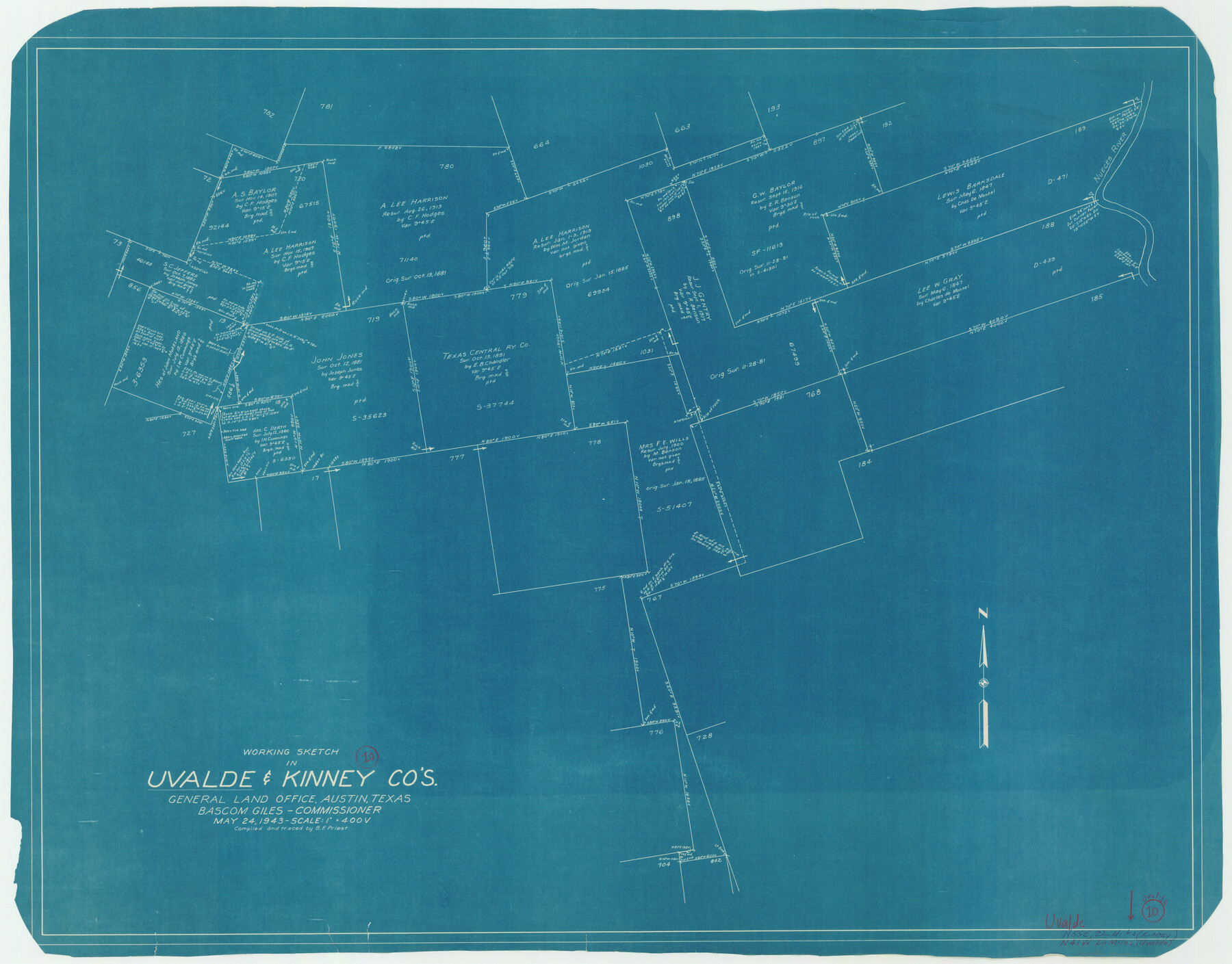
Uvalde County Working Sketch 10
-
Map/Doc
72080
-
Collection
General Map Collection
-
Object Dates
5/24/1943 (Creation Date)
-
People and Organizations
B.F. Priest (Draftsman)
-
Counties
Uvalde Kinney
-
Subjects
Surveying Working Sketch
-
Height x Width
30.3 x 38.7 inches
77.0 x 98.3 cm
-
Scale
1" = 400 varas
Part of: General Map Collection
Brazos River, Brazos River Sheet 5

Print $20.00
- Digital $50.00
Brazos River, Brazos River Sheet 5
1926
Size 27.4 x 21.7 inches
Map/Doc 69669
Winkler County Sketch File 3

Print $20.00
- Digital $50.00
Winkler County Sketch File 3
Size 38.6 x 33.8 inches
Map/Doc 10436
Borden County Boundary File 5a

Print $98.00
- Digital $50.00
Borden County Boundary File 5a
Size 13.3 x 8.1 inches
Map/Doc 50659
Travis County Rolled Sketch 28

Print $20.00
- Digital $50.00
Travis County Rolled Sketch 28
1941
Size 22.7 x 27.0 inches
Map/Doc 8030
Cass County Working Sketch 34

Print $20.00
- Digital $50.00
Cass County Working Sketch 34
1982
Size 21.1 x 24.6 inches
Map/Doc 67937
Mason County Rolled Sketch 3

Print $20.00
- Digital $50.00
Mason County Rolled Sketch 3
1965
Size 30.3 x 22.8 inches
Map/Doc 6676
Flight Mission No. DCL-5C, Frame 75, Kenedy County

Print $20.00
- Digital $50.00
Flight Mission No. DCL-5C, Frame 75, Kenedy County
1943
Size 18.6 x 22.2 inches
Map/Doc 85858
Ward County Sketch File 5

Print $5.00
- Digital $50.00
Ward County Sketch File 5
1873
Size 11.0 x 17.0 inches
Map/Doc 39619

Map of Coleman County

Print $40.00
- Digital $50.00
Map of Coleman County
1897
Size 49.9 x 34.2 inches
Map/Doc 4741
Flight Mission No. DCL-7C, Frame 120, Kenedy County

Print $20.00
- Digital $50.00
Flight Mission No. DCL-7C, Frame 120, Kenedy County
1943
Size 18.5 x 22.4 inches
Map/Doc 86085
Fort Bend County State Real Property Sketch 12

Print $40.00
- Digital $50.00
Fort Bend County State Real Property Sketch 12
1986
Size 43.2 x 35.0 inches
Map/Doc 61686
You may also like
Kaufman County Sketch File 10a

Print $20.00
- Digital $50.00
Kaufman County Sketch File 10a
1871
Size 18.3 x 14.6 inches
Map/Doc 11906
Preliminary Chart of the Sea Coast of Texas in the Vicinity of Galveston

Print $20.00
Preliminary Chart of the Sea Coast of Texas in the Vicinity of Galveston
1856
Size 26.3 x 19.7 inches
Map/Doc 76256
Ochiltree County Boundary File 4

Print $4.00
- Digital $50.00
Ochiltree County Boundary File 4
Size 11.1 x 8.7 inches
Map/Doc 57682
Comanche County Working Sketch 27

Print $40.00
- Digital $50.00
Comanche County Working Sketch 27
1983
Size 50.2 x 43.5 inches
Map/Doc 68161

Val Verde County Working Sketch 32

Print $20.00
- Digital $50.00
Val Verde County Working Sketch 32
1938
Size 41.5 x 24.2 inches
Map/Doc 72167

Edwards County Working Sketch 49

Print $20.00
- Digital $50.00
Edwards County Working Sketch 49
1950
Size 23.6 x 28.1 inches
Map/Doc 68925
Hood County Working Sketch 2

Print $20.00
- Digital $50.00
Hood County Working Sketch 2
1956
Size 20.5 x 25.5 inches
Map/Doc 66196
Atascosa County Sketch File 27a

Print $4.00
- Digital $50.00
Atascosa County Sketch File 27a
Size 8.4 x 14.3 inches
Map/Doc 13799
Leon County Rolled Sketch 33

Print $20.00
- Digital $50.00
Leon County Rolled Sketch 33
1997
Size 26.3 x 36.7 inches
Map/Doc 6617
Duval County Sketch File 33

Print $55.00
- Digital $50.00
Duval County Sketch File 33
1932
Size 14.4 x 8.8 inches
Map/Doc 21342