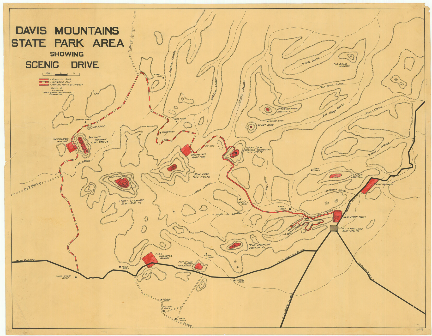
Davis Mountains State Park Area Showing Scenic Drive
-
Map/Doc
76312
-
Collection
Texas State Library and Archives
-
Object Dates
1935 (Creation Date)
-
People and Organizations
R.D. Swartz (Draftsman)
-
Counties
Jeff Davis
-
Subjects
Topographic
-
Height x Width
26.9 x 34.5 inches
68.3 x 87.6 cm
-
Comments
Prints available courtesy of the Texas State Library and Archives.
More info can be found here: TSLAC Map 06930
Part of: Texas State Library and Archives
General Highway Map, Llano County, Texas

Print $20.00
General Highway Map, Llano County, Texas
1940
Size 18.4 x 24.9 inches
Map/Doc 79178
Texas Oil and Gas Fields and Truck Pipe Line Systems

Print $20.00
Texas Oil and Gas Fields and Truck Pipe Line Systems
1926
Size 21.7 x 30.8 inches
Map/Doc 79327
General Highway Map, Stephens County, Texas

Print $20.00
General Highway Map, Stephens County, Texas
1961
Size 25.0 x 18.2 inches
Map/Doc 79660
General Highway Map. Detail of Cities and Towns in Bexar County, Texas. City Map of San Antonio, Alamo Heights, Olmos Park, Terrell Hills, Castle Hills, Balcones Heights, and vicinity, Bexar County, Texas

Print $20.00
General Highway Map. Detail of Cities and Towns in Bexar County, Texas. City Map of San Antonio, Alamo Heights, Olmos Park, Terrell Hills, Castle Hills, Balcones Heights, and vicinity, Bexar County, Texas
1961
Size 18.2 x 25.0 inches
Map/Doc 79375
General Highway Map, Wood County, Texas

Print $20.00
General Highway Map, Wood County, Texas
1961
Size 18.1 x 24.8 inches
Map/Doc 79718
Post Route Map of the State of Texas with Adjacent Parts of Louisiana, Arkansas, Indian Territory and the Republic of Mexico Showing Post Offices with the Intermediate Distances and Mail Routes in Operation on the 1st of April 1891

Print $40.00
Post Route Map of the State of Texas with Adjacent Parts of Louisiana, Arkansas, Indian Territory and the Republic of Mexico Showing Post Offices with the Intermediate Distances and Mail Routes in Operation on the 1st of April 1891
1891
Size 44.5 x 58.2 inches
Map/Doc 89061
Principal Watersheds of Texas

Print $20.00
Principal Watersheds of Texas
1935
Size 34.8 x 45.1 inches
Map/Doc 76306
A Map of Texas Showing the State Parks and the Municipal Parks

Print $20.00
A Map of Texas Showing the State Parks and the Municipal Parks
1936
Size 34.8 x 37.5 inches
Map/Doc 76311
General Highway Map, Leon County, Texas

Print $20.00
General Highway Map, Leon County, Texas
1961
Size 18.3 x 24.8 inches
Map/Doc 79568
General Highway Map, Edwards County, Real County, Texas

Print $20.00
General Highway Map, Edwards County, Real County, Texas
1940
Size 18.3 x 24.8 inches
Map/Doc 79082
County Map of the Pan-Handle of Texas, and the line of the Denver, Texas and Ft. Worth R'y

Print $20.00
County Map of the Pan-Handle of Texas, and the line of the Denver, Texas and Ft. Worth R'y
1888
Size 7.5 x 10.9 inches
Map/Doc 76296
General Highway Map, Hale County, Texas

Print $20.00
General Highway Map, Hale County, Texas
1940
Size 24.8 x 18.4 inches
Map/Doc 79108
You may also like
Montgomery County Rolled Sketch 17

Print $20.00
- Digital $50.00
Montgomery County Rolled Sketch 17
Size 26.6 x 34.9 inches
Map/Doc 6805
Wilbarger County Sketch File 28

Print $20.00
- Digital $50.00
Wilbarger County Sketch File 28
2016
Size 23.9 x 36.2 inches
Map/Doc 95324

St. Louis, Brownsville & Mexico Railway Location Map from Mile 80 to Mile 100

Print $40.00
- Digital $50.00
St. Louis, Brownsville & Mexico Railway Location Map from Mile 80 to Mile 100
1905
Size 19.5 x 64.6 inches
Map/Doc 64166
Hopkins County Boundary File 3a

Print $4.00
- Digital $50.00
Hopkins County Boundary File 3a
Size 10.7 x 8.7 inches
Map/Doc 55082
Flight Mission No. BRE-1P, Frame 123, Nueces County

Print $20.00
- Digital $50.00
Flight Mission No. BRE-1P, Frame 123, Nueces County
1956
Size 18.6 x 22.7 inches
Map/Doc 86689
Carte de la Louisiane cours du Mississipi et pais voisins dediée à M. le Comte de Maurepas, Ministre et Secretaire d'Etat Commandeur des Ordres du Roy

Print $20.00
- Digital $50.00
Carte de la Louisiane cours du Mississipi et pais voisins dediée à M. le Comte de Maurepas, Ministre et Secretaire d'Etat Commandeur des Ordres du Roy
1744
Size 17.5 x 23.3 inches
Map/Doc 94496
Flight Mission No. CGI-4N, Frame 160, Cameron County

Print $20.00
- Digital $50.00
Flight Mission No. CGI-4N, Frame 160, Cameron County
1955
Size 18.5 x 22.3 inches
Map/Doc 84668
Hardeman County Boundary File 3a

Print $42.00
- Digital $50.00
Hardeman County Boundary File 3a
Size 56.8 x 12.3 inches
Map/Doc 54384
Presidio County Working Sketch 22

Print $20.00
- Digital $50.00
Presidio County Working Sketch 22
1945
Size 31.7 x 21.9 inches
Map/Doc 71698
Flight Mission No. CUG-3P, Frame 169, Kleberg County

Print $20.00
- Digital $50.00
Flight Mission No. CUG-3P, Frame 169, Kleberg County
1956
Size 18.5 x 22.2 inches
Map/Doc 86289
McMullen County Rolled Sketch 20

Print $20.00
- Digital $50.00
McMullen County Rolled Sketch 20
Size 27.7 x 21.7 inches
Map/Doc 6736