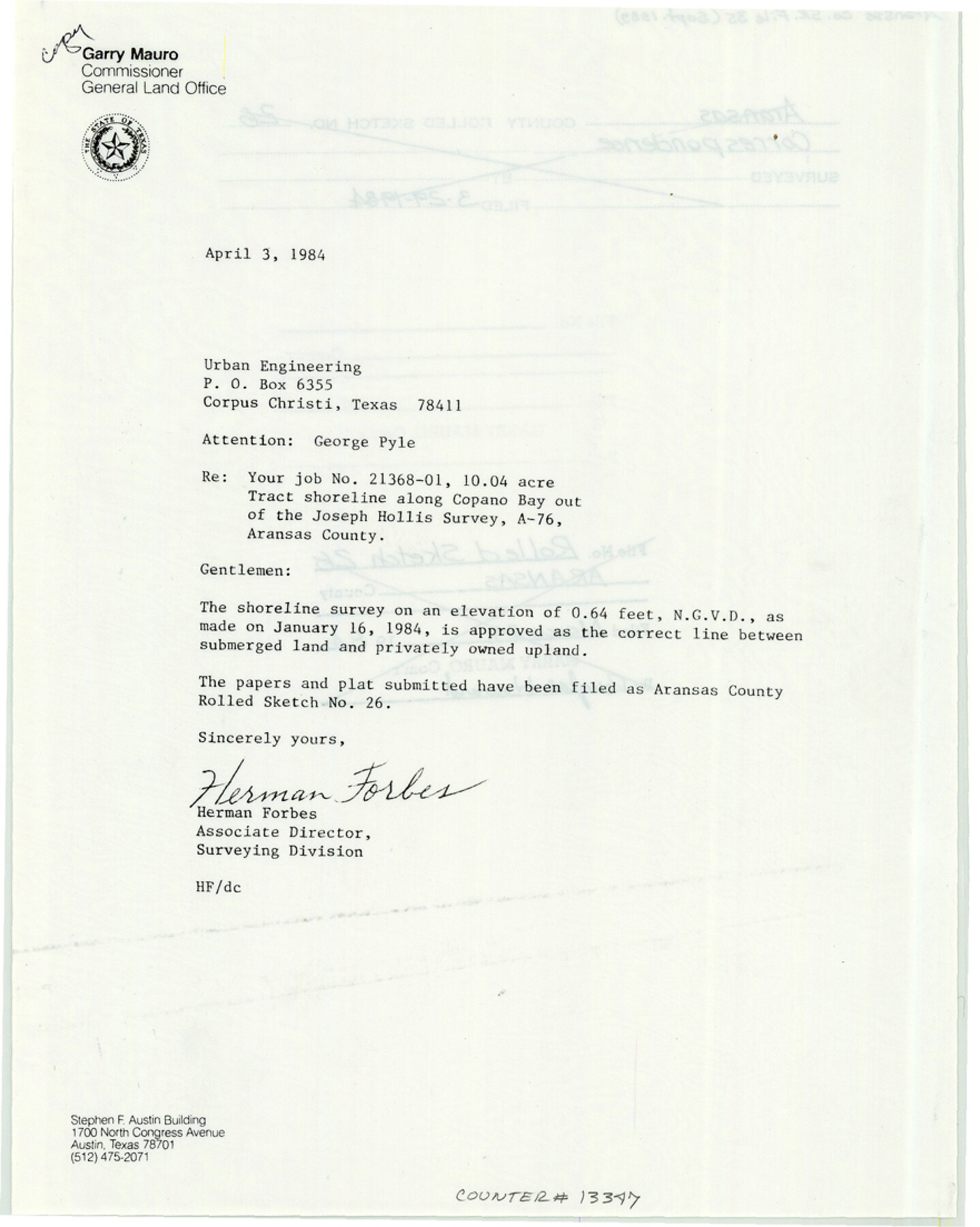
Aransas County Sketch File 35
[Aerial photos and correspondence regarding 10.04 ac. of land out of Joseph Hollis survey, abstract 76]
-
Map/Doc
13347
-
Collection
General Map Collection
-
Object Dates
1984/3/29 (File Date)
1984/3/26 (Creation Date)
-
People and Organizations
George M. Pyle (Surveyor/Engineer)
-
Counties
Aransas
-
Subjects
Aerial Photograph Surveying Sketch File
-
Height x Width
11.0 x 8.8 inches
27.9 x 22.4 cm
-
Medium
multi-page, multi-format
-
Comments
See Aransas County Rolled Sketch 26 (5060) for sketch.
-
Features
Mud Flat
Rockport
Little Bay
Ninemile Point
Aransas Bay
Intracoastal Waterway
Italian Bend
Port Bay
Swan Lake
Live Oak Peninsula
Frandolig Island
T&NO
Copano House
Mission Bay
Copano Ridge Road
Copano Camp Site Subdivision
Copano Ridge Subdivision
Copano Bay
Fulton
Grass Island
Live Oak Point
Aransas County Airport
Copano Village
Hannibal Point
Rattlesnake Point
Smith Channel
Salt Lake
Lone Tree Point
Rincon de la Cera
Egery Island
Aransas River
Black Point
Bayside
Related maps
Aransas County Rolled Sketch 26

Print $20.00
- Digital $50.00
Aransas County Rolled Sketch 26
1984
Size 18.3 x 24.4 inches
Map/Doc 5060
Part of: General Map Collection
Lamb County Sketch File 13

Print $42.00
- Digital $50.00
Lamb County Sketch File 13
1914
Size 9.1 x 8.6 inches
Map/Doc 29371
Hardin County

Print $20.00
- Digital $50.00
Hardin County
1894
Size 46.8 x 43.4 inches
Map/Doc 16846
Goliad County Sketch File 41

Print $20.00
- Digital $50.00
Goliad County Sketch File 41
1958
Size 25.2 x 35.3 inches
Map/Doc 11573
Scurry County Rolled Sketch 11

Print $20.00
- Digital $50.00
Scurry County Rolled Sketch 11
Size 20.2 x 16.8 inches
Map/Doc 7771
Callahan County Sketch File 12

Print $40.00
- Digital $50.00
Callahan County Sketch File 12
1872
Size 17.8 x 26.2 inches
Map/Doc 11041
Texas Intracoastal Waterway - Laguna Madre - Rincon de San Jose to Chubby Island

Print $20.00
- Digital $50.00
Texas Intracoastal Waterway - Laguna Madre - Rincon de San Jose to Chubby Island
1957
Size 39.2 x 27.1 inches
Map/Doc 73512
East Part of Jeff Davis Co.

Print $20.00
- Digital $50.00
East Part of Jeff Davis Co.
1977
Size 40.6 x 30.9 inches
Map/Doc 77327
Tyler County Sketch File 23

Print $20.00
- Digital $50.00
Tyler County Sketch File 23
Size 25.3 x 20.9 inches
Map/Doc 12500
Denton County Boundary File 4 and 4a and 4b and 4c

Print $14.00
- Digital $50.00
Denton County Boundary File 4 and 4a and 4b and 4c
Size 11.2 x 8.5 inches
Map/Doc 52441
United States - Gulf Coast - Galveston to Rio Grande

Print $20.00
- Digital $50.00
United States - Gulf Coast - Galveston to Rio Grande
1919
Size 27.0 x 18.2 inches
Map/Doc 72748
San Luis Pass to East Matagorda Bay

Print $20.00
- Digital $50.00
San Luis Pass to East Matagorda Bay
1976
Size 35.1 x 46.7 inches
Map/Doc 69969
Ellis County Sketch File 11

Print $40.00
- Digital $50.00
Ellis County Sketch File 11
1860
Size 12.6 x 16.2 inches
Map/Doc 21847
You may also like
[Texas & Pacific Railway through Callahan County]
![64236, [Texas & Pacific Railway through Callahan County], General Map Collection](https://historictexasmaps.com/wmedia_w700/maps/64236.tif.jpg)
Print $20.00
- Digital $50.00
[Texas & Pacific Railway through Callahan County]
1918
Size 22.9 x 8.8 inches
Map/Doc 64236
Flight Mission No. BQY-15M, Frame 11, Harris County

Print $20.00
- Digital $50.00
Flight Mission No. BQY-15M, Frame 11, Harris County
1953
Size 18.5 x 22.4 inches
Map/Doc 85309

Upton County Sketch File 42

Print $3.00
- Digital $50.00
Upton County Sketch File 42
1986
Size 10.9 x 17.0 inches
Map/Doc 38919
Liberty County Working Sketch 26

Print $20.00
- Digital $50.00
Liberty County Working Sketch 26
1941
Size 29.8 x 26.4 inches
Map/Doc 70485
[E. L. & R.R. Block 1, G. C. & S. F. Blocks 1 & 2, T. R. R. Block 4]
![91280, [E. L. & R.R. Block 1, G. C. & S. F. Blocks 1 & 2, T. R. R. Block 4], Twichell Survey Records](https://historictexasmaps.com/wmedia_w700/maps/91280-1.tif.jpg)
Print $20.00
- Digital $50.00
[E. L. & R.R. Block 1, G. C. & S. F. Blocks 1 & 2, T. R. R. Block 4]
Size 8.7 x 19.3 inches
Map/Doc 91280
Nueces County Sketch File 60

Print $14.00
- Digital $50.00
Nueces County Sketch File 60
1940
Size 11.1 x 8.8 inches
Map/Doc 32962
Burnet County Sketch File 38

Print $20.00
- Digital $50.00
Burnet County Sketch File 38
1935
Size 37.8 x 24.5 inches
Map/Doc 11027
Sutton County Sketch File H

Print $22.00
- Digital $50.00
Sutton County Sketch File H
Size 14.3 x 8.7 inches
Map/Doc 37400
Engineer's Office, Department of the Gulf Map No. 59, Texas prepared by order of Maj. Gen. N. P. Banks under direction of Capt. P. C. Hains, U. S. Engr. & Chief Engr., Dept. of the Gulf

Print $20.00
- Digital $50.00
Engineer's Office, Department of the Gulf Map No. 59, Texas prepared by order of Maj. Gen. N. P. Banks under direction of Capt. P. C. Hains, U. S. Engr. & Chief Engr., Dept. of the Gulf
1865
Size 18.3 x 27.6 inches
Map/Doc 72717
Shackelford County Working Sketch 11

Print $20.00
- Digital $50.00
Shackelford County Working Sketch 11
1993
Size 16.2 x 37.8 inches
Map/Doc 63851
Maps & Lists Showing Prison Lands (Oil & Gas) Leased as of June 1955

Digital $50.00
Maps & Lists Showing Prison Lands (Oil & Gas) Leased as of June 1955
Size 11.4 x 7.0 inches
Map/Doc 62864