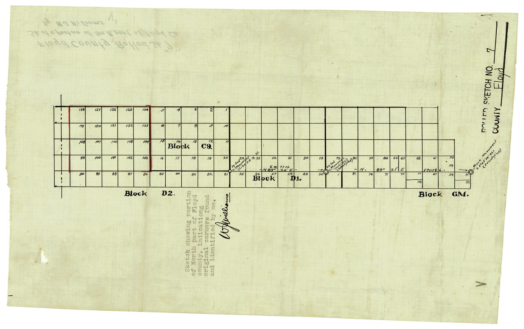
Floyd County Rolled Sketch 7
[Sketch of a portion of the N. part of Floyd County, Texas]
-
Map/Doc
5881
-
Collection
General Map Collection
-
People and Organizations
W.J. Williams (Surveyor/Engineer)
-
Counties
Floyd
-
Subjects
Surveying Rolled Sketch
-
Height x Width
8.7 x 13.9 inches
22.1 x 35.3 cm
-
Medium
linen, manuscript
Part of: General Map Collection
San Augustine County Working Sketch 23

Print $20.00
- Digital $50.00
San Augustine County Working Sketch 23
1974
Size 23.6 x 36.4 inches
Map/Doc 63711
Maverick County Working Sketch 2

Print $20.00
- Digital $50.00
Maverick County Working Sketch 2
1922
Size 46.2 x 38.5 inches
Map/Doc 70894
Cette Carte de Californie et du Nouveau Mexique est tiree de celle qui a ete envoyee par un grand d'Espagne pour etre communiquee a Mrs. de l'Academie Royale des Sciences

Print $20.00
- Digital $50.00
Cette Carte de Californie et du Nouveau Mexique est tiree de celle qui a ete envoyee par un grand d'Espagne pour etre communiquee a Mrs. de l'Academie Royale des Sciences
1700
Size 11.8 x 16.5 inches
Map/Doc 95924
Travis County Working Sketch 22

Print $20.00
- Digital $50.00
Travis County Working Sketch 22
1947
Size 19.6 x 20.8 inches
Map/Doc 69406
Wise County Rolled Sketch 7

Print $20.00
- Digital $50.00
Wise County Rolled Sketch 7
Size 23.9 x 18.4 inches
Map/Doc 8281
Midland County Working Sketch 14

Print $40.00
- Digital $50.00
Midland County Working Sketch 14
1953
Size 65.0 x 31.0 inches
Map/Doc 70994
Rio Grande, Donna Sheet

Print $20.00
- Digital $50.00
Rio Grande, Donna Sheet
1937
Size 37.5 x 37.4 inches
Map/Doc 65117
Lee County Working Sketch 22

Print $20.00
- Digital $50.00
Lee County Working Sketch 22
2010
Size 29.2 x 29.6 inches
Map/Doc 89271
Sherman County Rolled Sketch 14

Print $20.00
- Digital $50.00
Sherman County Rolled Sketch 14
1975
Size 17.4 x 17.7 inches
Map/Doc 7795
Jeff Davis County Working Sketch 19

Print $40.00
- Digital $50.00
Jeff Davis County Working Sketch 19
1957
Size 71.3 x 34.1 inches
Map/Doc 66514
Liberty County Rolled Sketch 12

Print $20.00
- Digital $50.00
Liberty County Rolled Sketch 12
1983
Size 26.5 x 22.6 inches
Map/Doc 6618
Trinity County Working Sketch 25

Print $20.00
- Digital $50.00
Trinity County Working Sketch 25
2010
Size 39.7 x 28.7 inches
Map/Doc 89600
You may also like
Upton County Working Sketch 12

Print $40.00
- Digital $50.00
Upton County Working Sketch 12
1937
Size 43.6 x 77.9 inches
Map/Doc 69508
Fisher County Boundary File 2

Print $18.00
- Digital $50.00
Fisher County Boundary File 2
Size 14.4 x 8.9 inches
Map/Doc 53419
Maps of Gulf Intracoastal Waterway, Texas - Sabine River to the Rio Grande and connecting waterways including ship channels

Print $20.00
- Digital $50.00
Maps of Gulf Intracoastal Waterway, Texas - Sabine River to the Rio Grande and connecting waterways including ship channels
1966
Size 14.6 x 22.2 inches
Map/Doc 61952
Howard County Working Sketch 10

Print $20.00
- Digital $50.00
Howard County Working Sketch 10
1962
Size 24.4 x 26.1 inches
Map/Doc 66278
Hemphill County Working Sketch 20

Print $20.00
- Digital $50.00
Hemphill County Working Sketch 20
1972
Size 34.9 x 47.1 inches
Map/Doc 66115
La Salle County Sketch File 3

Print $44.00
- Digital $50.00
La Salle County Sketch File 3
1875
Size 15.8 x 29.6 inches
Map/Doc 11978
Bosque County Working Sketch 20

Print $20.00
- Digital $50.00
Bosque County Working Sketch 20
1976
Size 37.4 x 32.8 inches
Map/Doc 67453
Live Oak County Boundary File 1

Print $24.00
- Digital $50.00
Live Oak County Boundary File 1
Size 9.0 x 4.2 inches
Map/Doc 56387
Galveston County Sketch File 18

Print $4.00
- Digital $50.00
Galveston County Sketch File 18
Size 5.5 x 8.0 inches
Map/Doc 23388
Donley County Rolled Sketch 5

Print $40.00
- Digital $50.00
Donley County Rolled Sketch 5
1982
Size 56.6 x 32.9 inches
Map/Doc 8801
Padre Island National Seashore, Texas - Dependent Resurvey

Print $4.00
- Digital $50.00
Padre Island National Seashore, Texas - Dependent Resurvey
2001
Size 18.4 x 24.0 inches
Map/Doc 60551
[Leagues 247, 320, and 321]
![91290, [Leagues 247, 320, and 321], Twichell Survey Records](https://historictexasmaps.com/wmedia_w700/maps/91290-1.tif.jpg)
Print $2.00
- Digital $50.00
[Leagues 247, 320, and 321]
Size 7.8 x 14.5 inches
Map/Doc 91290