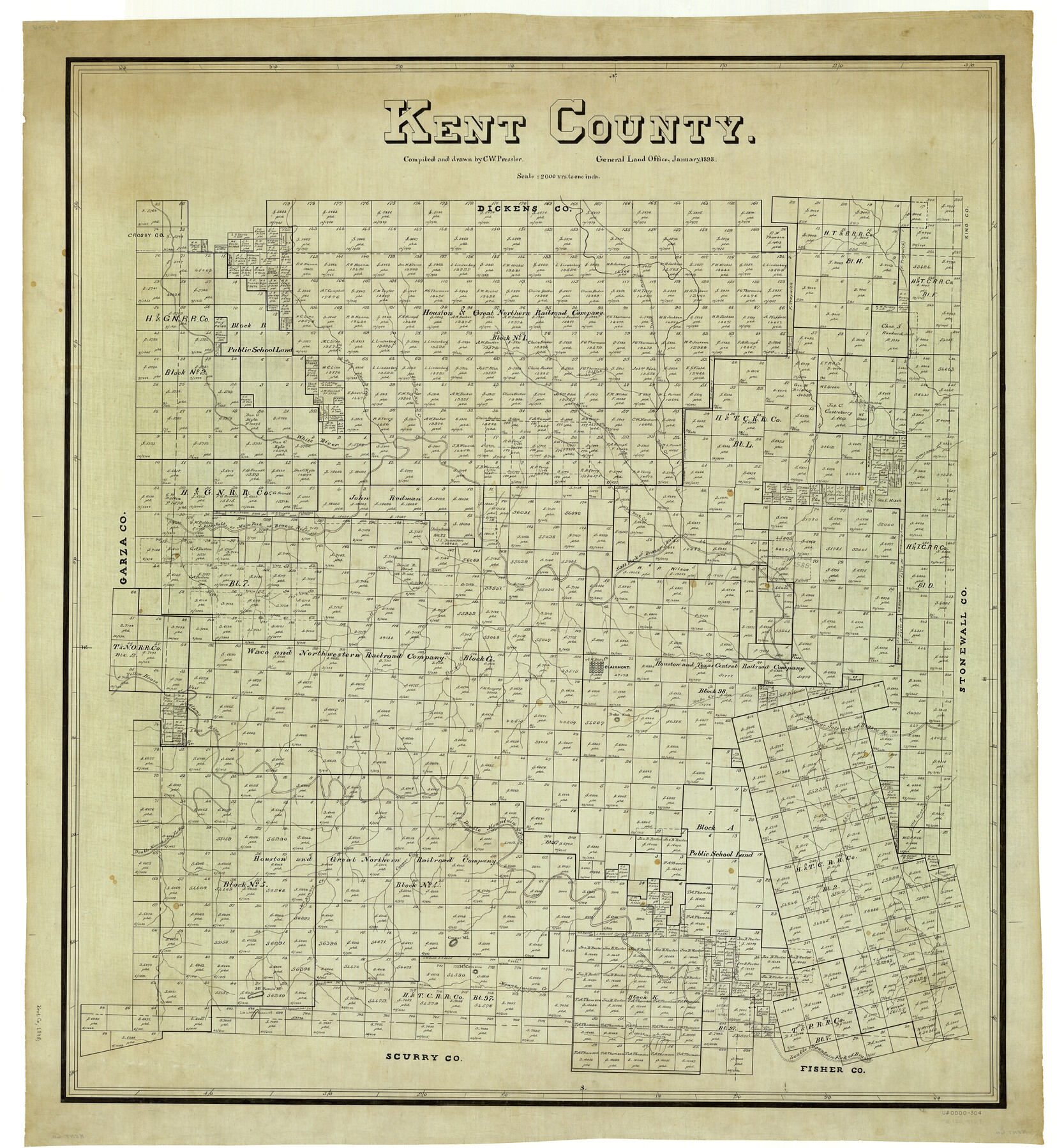
Kent County
-
Map/Doc
5001
-
Collection
General Map Collection
-
Object Dates
1898 (Creation Date)
-
People and Organizations
Texas General Land Office (Publisher)
Chas. W. Pressler (Draftsman)
Chas. W. Pressler (Compiler)
-
Counties
Kent
-
Subjects
County
-
Height x Width
42.1 x 38.7 inches
106.9 x 98.3 cm
Part of: General Map Collection
Upshur County Sketch File 12

Print $8.00
- Digital $50.00
Upshur County Sketch File 12
Size 10.3 x 8.0 inches
Map/Doc 38751

Fisher County

Print $20.00
- Digital $50.00
Fisher County
1944
Size 41.4 x 36.1 inches
Map/Doc 77279
Andrews County Rolled Sketch 26

Print $40.00
- Digital $50.00
Andrews County Rolled Sketch 26
1948
Size 78.3 x 13.2 inches
Map/Doc 8398
Somervell County Working Sketch Graphic Index

Print $20.00
- Digital $50.00
Somervell County Working Sketch Graphic Index
1941
Size 27.0 x 25.7 inches
Map/Doc 76700
Flight Mission No. BRA-6M, Frame 91, Jefferson County

Print $20.00
- Digital $50.00
Flight Mission No. BRA-6M, Frame 91, Jefferson County
1953
Size 18.5 x 22.4 inches
Map/Doc 85434
Edwards County Working Sketch 33

Print $40.00
- Digital $50.00
Edwards County Working Sketch 33
1947
Size 42.6 x 50.2 inches
Map/Doc 68909
Midland County Rolled Sketch 2

Print $20.00
- Digital $50.00
Midland County Rolled Sketch 2
1949
Size 39.3 x 36.5 inches
Map/Doc 9513
Right of Way & Track Map Houston & Brazos Valley Ry. operated by Houston & Brazos Valley Ry. Co., Hoskins Mound Branch

Print $40.00
- Digital $50.00
Right of Way & Track Map Houston & Brazos Valley Ry. operated by Houston & Brazos Valley Ry. Co., Hoskins Mound Branch
1924
Size 25.0 x 56.7 inches
Map/Doc 66713
Flight Mission No. BRA-9M, Frame 70, Jefferson County

Print $20.00
- Digital $50.00
Flight Mission No. BRA-9M, Frame 70, Jefferson County
1953
Size 18.6 x 22.5 inches
Map/Doc 85653
Sutton County Working Sketch 62

Print $20.00
- Digital $50.00
Sutton County Working Sketch 62
1959
Size 31.3 x 38.1 inches
Map/Doc 62405
Sherman County Sketch File 7

Print $2.00
- Digital $50.00
Sherman County Sketch File 7
1993
Size 14.6 x 9.0 inches
Map/Doc 36725
You may also like
Blanco County Sketch File 52

Print $4.00
- Digital $50.00
Blanco County Sketch File 52
Size 11.3 x 8.9 inches
Map/Doc 76332
[E. T. RR. Block 1]
![93186, [E. T. RR. Block 1], Twichell Survey Records](https://historictexasmaps.com/wmedia_w700/maps/93186-1.tif.jpg)
Print $40.00
- Digital $50.00
[E. T. RR. Block 1]
Size 69.6 x 52.7 inches
Map/Doc 93186
Coast Chart No. 211 - Padre I. and Laguna Madre, Lat. 27° 12' to Lat. 26° 33', Texas

Print $20.00
- Digital $50.00
Coast Chart No. 211 - Padre I. and Laguna Madre, Lat. 27° 12' to Lat. 26° 33', Texas
1890
Size 41.0 x 33.4 inches
Map/Doc 73501
Webb County Sketch File 9a

Print $20.00
- Digital $50.00
Webb County Sketch File 9a
1930
Size 31.4 x 23.9 inches
Map/Doc 12619
Greer County Sketch File 6

Print $4.00
- Digital $50.00
Greer County Sketch File 6
Size 14.2 x 8.8 inches
Map/Doc 24524
Layout of the porciones as described in the Visita General of Revilla (Guerrero), 1767, along with six tracts distributed by Gov. Lasaga in 1784 and three others (39-41) assigned at a later date

Layout of the porciones as described in the Visita General of Revilla (Guerrero), 1767, along with six tracts distributed by Gov. Lasaga in 1784 and three others (39-41) assigned at a later date
2009
Size 11.0 x 8.5 inches
Map/Doc 94044
Texas for Tourists, a highway and reference map published by the Dallas Morning News for the Texas Almanac and State Industrial Guide

Texas for Tourists, a highway and reference map published by the Dallas Morning News for the Texas Almanac and State Industrial Guide
1936
Size 20.3 x 26.4 inches
Map/Doc 94294
Travis County Rolled Sketch 55

Print $40.00
- Digital $50.00
Travis County Rolled Sketch 55
Size 43.1 x 50.5 inches
Map/Doc 10020
Kerr County Sketch File 21

Print $10.00
- Digital $50.00
Kerr County Sketch File 21
1954
Size 11.1 x 8.7 inches
Map/Doc 28892
Newton County Rolled Sketch 24
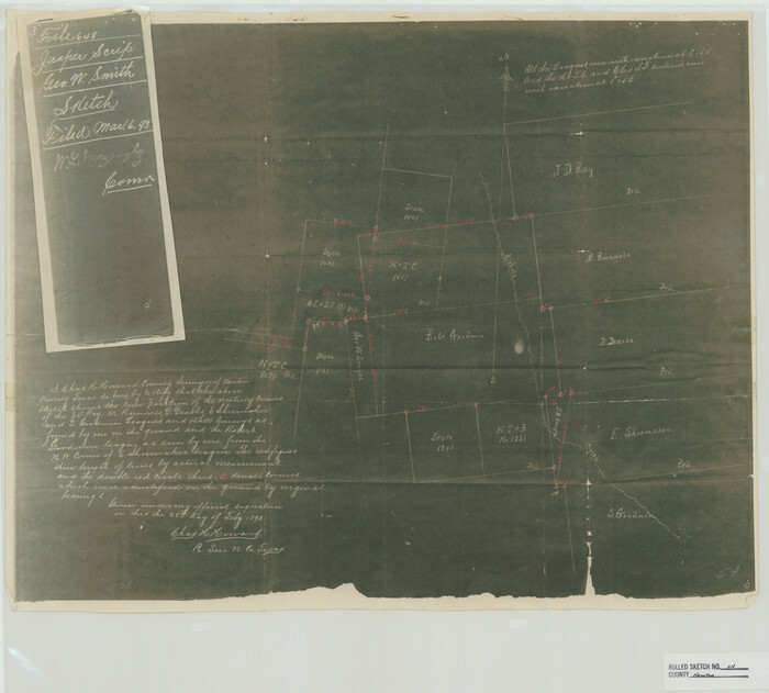
Print $20.00
- Digital $50.00
Newton County Rolled Sketch 24
1893
Size 18.8 x 20.8 inches
Map/Doc 6851
Lindner Subdivision out of the Baker Subdivision of the Cucharia Tract being Lots 11 and 14, San Salvador del Tule Grant Hidalgo Co. Texas and also showing the Ehlert-Krausse Sub. and the Townsite of Alsonia

Print $20.00
- Digital $50.00
Lindner Subdivision out of the Baker Subdivision of the Cucharia Tract being Lots 11 and 14, San Salvador del Tule Grant Hidalgo Co. Texas and also showing the Ehlert-Krausse Sub. and the Townsite of Alsonia
1927
Size 22.3 x 35.3 inches
Map/Doc 77093
