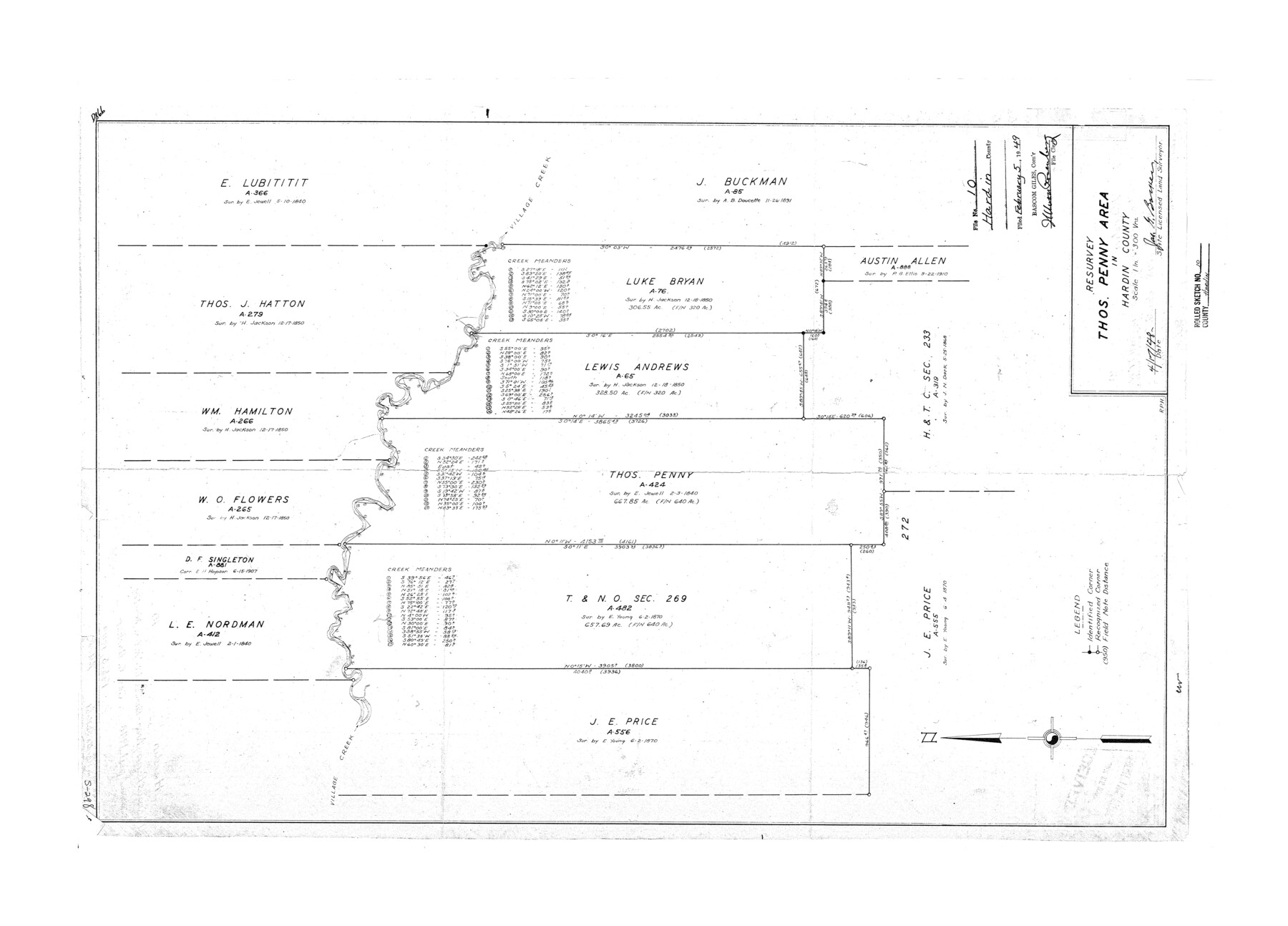
Hardin County Rolled Sketch 10
Resurvey Thos. Penny area in Hardin County
-
Map/Doc
6082
-
Collection
General Map Collection
-
Object Dates
1948/4/17 (Creation Date)
1949/2/5 (File Date)
-
People and Organizations
Jas. G. Barker (Surveyor/Engineer)
-
Counties
Hardin
-
Subjects
Surveying Rolled Sketch
-
Height x Width
23.7 x 33.0 inches
60.2 x 83.8 cm
-
Scale
1" = 300 varas
-
Comments
See Hardin County Sketch File 67 (25252) for report.
Related maps
Hardin County Sketch File 67

Print $10.00
- Digital $50.00
Hardin County Sketch File 67
Size 11.4 x 8.9 inches
Map/Doc 25252
Part of: General Map Collection
Northern Part of Laguna Madre

Print $20.00
- Digital $50.00
Northern Part of Laguna Madre
1949
Size 44.6 x 34.9 inches
Map/Doc 73524
Trinity River, Sand Lake Sheet

Print $40.00
- Digital $50.00
Trinity River, Sand Lake Sheet
1922
Size 29.4 x 49.7 inches
Map/Doc 65184
Duval County Sketch File 39

Print $20.00
- Digital $50.00
Duval County Sketch File 39
Size 32.1 x 23.9 inches
Map/Doc 11395
Flight Mission No. BRA-7M, Frame 75, Jefferson County

Print $20.00
- Digital $50.00
Flight Mission No. BRA-7M, Frame 75, Jefferson County
1953
Size 18.6 x 22.2 inches
Map/Doc 85497
Gregg County Rolled Sketch 26

Print $40.00
- Digital $50.00
Gregg County Rolled Sketch 26
1937
Size 25.8 x 129.0 inches
Map/Doc 9077
Map of the Straits of Florida and Gulf of Mexico

Print $20.00
- Digital $50.00
Map of the Straits of Florida and Gulf of Mexico
1851
Size 18.3 x 27.5 inches
Map/Doc 72676
Wheeler County Working Sketch 10

Print $40.00
- Digital $50.00
Wheeler County Working Sketch 10
1973
Size 72.4 x 36.6 inches
Map/Doc 72499
Flight Mission No. BRA-7M, Frame 17, Jefferson County

Print $20.00
- Digital $50.00
Flight Mission No. BRA-7M, Frame 17, Jefferson County
1953
Size 18.6 x 22.4 inches
Map/Doc 85468
Freestone County Working Sketch 19

Print $20.00
- Digital $50.00
Freestone County Working Sketch 19
1980
Size 39.3 x 44.4 inches
Map/Doc 69261
Haskell County Sketch File 12

Print $20.00
- Digital $50.00
Haskell County Sketch File 12
1881
Size 18.8 x 23.6 inches
Map/Doc 11741
Pecos County Working Sketch 126

Print $40.00
- Digital $50.00
Pecos County Working Sketch 126
1974
Size 83.6 x 38.2 inches
Map/Doc 71599
Railroad Track Map, H&TCRRCo., Falls County, Texas

Print $4.00
- Digital $50.00
Railroad Track Map, H&TCRRCo., Falls County, Texas
1918
Size 11.8 x 18.5 inches
Map/Doc 62860
You may also like
[Beaumont, Sour Lake and Western Ry. Right of Way and Alignment - Frisco]
![64125, [Beaumont, Sour Lake and Western Ry. Right of Way and Alignment - Frisco], General Map Collection](https://historictexasmaps.com/wmedia_w700/maps/64125.tif.jpg)
Print $20.00
- Digital $50.00
[Beaumont, Sour Lake and Western Ry. Right of Way and Alignment - Frisco]
1910
Size 20.1 x 45.9 inches
Map/Doc 64125
Sabine County Working Sketch 5

Print $20.00
- Digital $50.00
Sabine County Working Sketch 5
1918
Size 17.3 x 17.3 inches
Map/Doc 63676
Flight Mission No. DIX-6P, Frame 182, Aransas County

Print $20.00
- Digital $50.00
Flight Mission No. DIX-6P, Frame 182, Aransas County
1956
Size 19.1 x 22.8 inches
Map/Doc 83844


Hamilton County Rolled Sketch 13

Print $20.00
- Digital $50.00
Hamilton County Rolled Sketch 13
1982
Size 34.0 x 28.0 inches
Map/Doc 6062
[Sketch of sections 59-64, I. & G. N. Block 1 and part of Block Z]
![93167, [Sketch of sections 59-64, I. & G. N. Block 1 and part of Block Z], Twichell Survey Records](https://historictexasmaps.com/wmedia_w700/maps/93167-1.tif.jpg)
Print $40.00
- Digital $50.00
[Sketch of sections 59-64, I. & G. N. Block 1 and part of Block Z]
Size 74.8 x 43.5 inches
Map/Doc 93167
Hartley County Working Sketch 7

Print $20.00
- Digital $50.00
Hartley County Working Sketch 7
1971
Size 20.1 x 25.1 inches
Map/Doc 66057
Nueces County Working Sketch 10

Print $20.00
- Digital $50.00
Nueces County Working Sketch 10
1963
Size 26.7 x 27.7 inches
Map/Doc 71312
Terry County Sketch File 5

Print $40.00
- Digital $50.00
Terry County Sketch File 5
1916
Size 15.6 x 58.6 inches
Map/Doc 10391
Andrews County Sketch File 3

Print $46.00
- Digital $50.00
Andrews County Sketch File 3
1928
Size 33.0 x 36.6 inches
Map/Doc 10317
Webb County Rolled Sketch 54

Print $20.00
- Digital $50.00
Webb County Rolled Sketch 54
1935
Size 24.7 x 18.8 inches
Map/Doc 8206