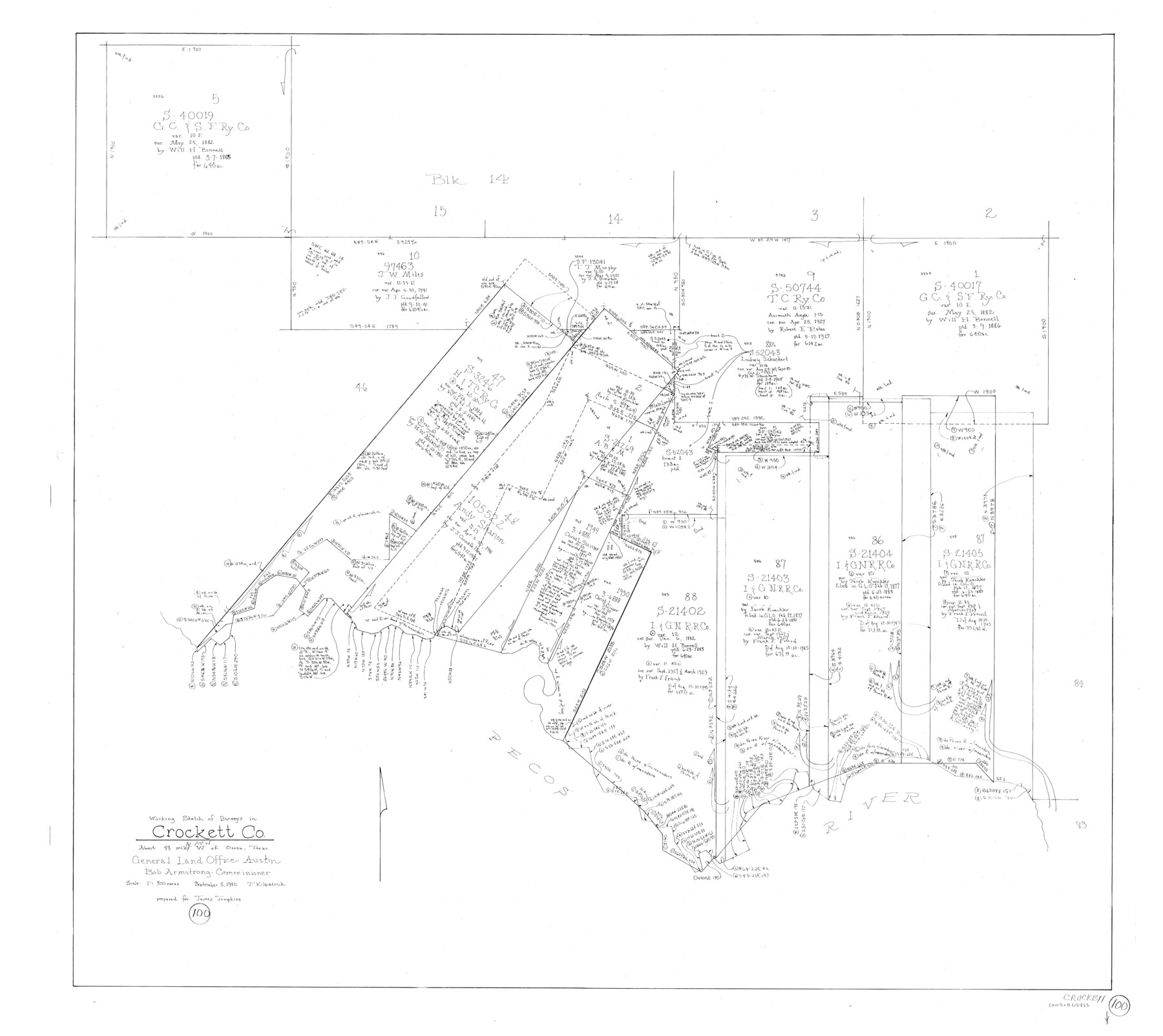
Crockett County Working Sketch 100
-
Map/Doc
68433
-
Collection
General Map Collection
-
Object Dates
9/5/1980 (Creation Date)
-
People and Organizations
Joan Kilpatrick (Draftsman)
-
Counties
Crockett
-
Subjects
Surveying Working Sketch
-
Height x Width
35.6 x 39.9 inches
90.4 x 101.4 cm
-
Scale
1" = 300 varas
Part of: General Map Collection
Map of Cherokee County

Print $20.00
- Digital $50.00
Map of Cherokee County
1851
Size 24.6 x 18.3 inches
Map/Doc 3386
Panola County Working Sketch 24

Print $20.00
- Digital $50.00
Panola County Working Sketch 24
1957
Map/Doc 71433
Map of Archer County, Young Land District, formerly Fannin Land District

Print $20.00
- Digital $50.00
Map of Archer County, Young Land District, formerly Fannin Land District
1859
Size 25.2 x 21.6 inches
Map/Doc 3237
Anderson County Rolled Sketch 14

Print $20.00
- Digital $50.00
Anderson County Rolled Sketch 14
1997
Size 30.1 x 36.5 inches
Map/Doc 77159
Jefferson County Rolled Sketch 60

Print $20.00
- Digital $50.00
Jefferson County Rolled Sketch 60
1885
Size 34.0 x 35.9 inches
Map/Doc 9316
Polk County Sketch File 36

Print $46.00
- Digital $50.00
Polk County Sketch File 36
1908
Size 13.8 x 8.6 inches
Map/Doc 34236
Howard County Rolled Sketch 2

Print $20.00
- Digital $50.00
Howard County Rolled Sketch 2
1905
Size 27.6 x 23.0 inches
Map/Doc 6232
Cameron County Rolled Sketch 26

Print $20.00
- Digital $50.00
Cameron County Rolled Sketch 26
Size 18.5 x 24.3 inches
Map/Doc 5390
Nacogdoches County Sketch File 20

Print $26.00
- Digital $50.00
Nacogdoches County Sketch File 20
Size 12.6 x 7.9 inches
Map/Doc 32275
Presidio County Working Sketch 112

Print $20.00
- Digital $50.00
Presidio County Working Sketch 112
1979
Size 41.7 x 35.6 inches
Map/Doc 71789
Montague County Working Sketch 21

Print $20.00
- Digital $50.00
Montague County Working Sketch 21
1952
Size 33.1 x 39.5 inches
Map/Doc 71087
Flight Mission No. DQN-1K, Frame 77, Calhoun County

Print $20.00
- Digital $50.00
Flight Mission No. DQN-1K, Frame 77, Calhoun County
1953
Size 18.5 x 22.2 inches
Map/Doc 84162
You may also like

Military Map of Western Texas

Print $20.00
Military Map of Western Texas
1884
Size 24.1 x 38.2 inches
Map/Doc 76315
Darrington Plantation of the Texas Prison System, Brazoria County

Print $20.00
- Digital $50.00
Darrington Plantation of the Texas Prison System, Brazoria County
Size 16.9 x 37.4 inches
Map/Doc 62986
Wise County Working Sketch 5

Print $20.00
- Digital $50.00
Wise County Working Sketch 5
1948
Size 25.7 x 23.4 inches
Map/Doc 72619
McMullen County Sketch File 24

Print $22.00
- Digital $50.00
McMullen County Sketch File 24
Size 8.7 x 12.6 inches
Map/Doc 31381

Angelina County Sketch File 18

Print $4.00
- Digital $50.00
Angelina County Sketch File 18
Size 8.6 x 3.9 inches
Map/Doc 13028
La Salle County Rolled Sketch 23

Print $40.00
- Digital $50.00
La Salle County Rolled Sketch 23
1956
Size 34.5 x 48.0 inches
Map/Doc 9559
General Highway Map, Fort Bend County, Texas

Print $20.00
General Highway Map, Fort Bend County, Texas
1961
Size 18.1 x 24.5 inches
Map/Doc 79469
Atascosa County Rolled Sketch 24

Print $20.00
- Digital $50.00
Atascosa County Rolled Sketch 24
Size 38.3 x 45.2 inches
Map/Doc 5101
[Surveys near the city of Bastrop]
![107, [Surveys near the city of Bastrop], General Map Collection](https://historictexasmaps.com/wmedia_w700/maps/107.tif.jpg)
Print $2.00
- Digital $50.00
[Surveys near the city of Bastrop]
1841
Size 6.5 x 7.0 inches
Map/Doc 107
Matagorda Bay and Approaches

Print $20.00
- Digital $50.00
Matagorda Bay and Approaches
1961
Size 35.0 x 45.0 inches
Map/Doc 73382