El Paso County Sketch File 35 (1)
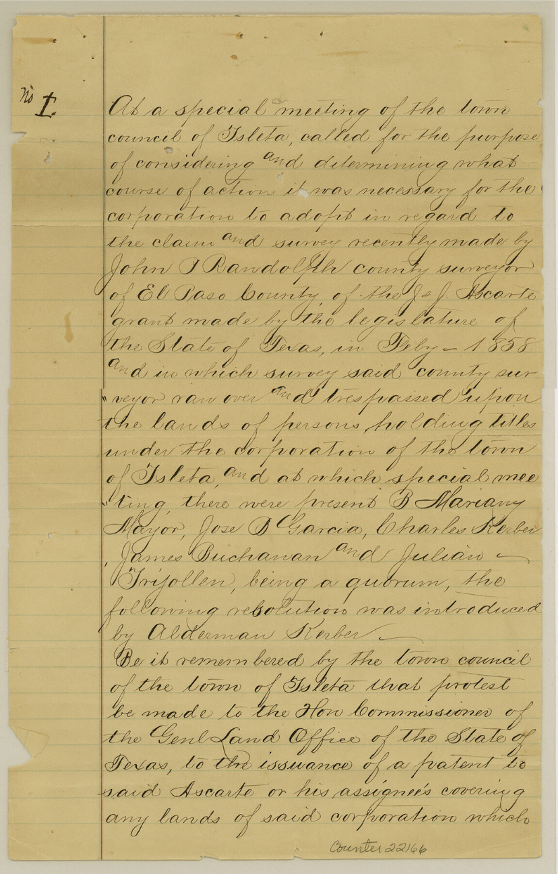
[Resolution of the Town Council of Ysleta]
-
Map/Doc
22166
-
Collection
General Map Collection
-
Object Dates
12/12/1984 (File Date)
2/1858 (Survey Date)
1873 (Survey Date)
1853 (Survey Date)
-
People and Organizations
John P. Randolph (Surveyor/Engineer)
J.W. Tays (Surveyor/Engineer)
-
Counties
El Paso
-
Subjects
Surveying Sketch File
-
Height x Width
13.0 x 8.3 inches
33.0 x 21.1 cm
-
Medium
paper, manuscript
-
Comments
See related: El Paso County Sketch Files 35 (22161), 35(2) (22170), 35(3) (22179), 35(4) (22199), 35(5) (22218), 35(6) (11460)
Formerly filed as Letter File 194001 ½ -
Features
Isleta [sic]
Related maps
El Paso County Sketch File 35 (6)

Print $20.00
- Digital $50.00
El Paso County Sketch File 35 (6)
1886
Size 20.3 x 36.9 inches
Map/Doc 11460
El Paso County Sketch File 35

Print $10.00
- Digital $50.00
El Paso County Sketch File 35
1886
Size 11.3 x 8.9 inches
Map/Doc 22161
El Paso County Sketch File 35 (2)

Print $18.00
- Digital $50.00
El Paso County Sketch File 35 (2)
1886
Size 12.9 x 8.3 inches
Map/Doc 22170
El Paso County Sketch File 35 (3)

Print $40.00
- Digital $50.00
El Paso County Sketch File 35 (3)
1886
Size 12.8 x 8.3 inches
Map/Doc 22179
El Paso County Sketch File 35 (4)

Print $38.00
- Digital $50.00
El Paso County Sketch File 35 (4)
1886
Size 14.3 x 9.0 inches
Map/Doc 22199
El Paso County Sketch File 35 (5)

Print $6.00
- Digital $50.00
El Paso County Sketch File 35 (5)
1886
Size 14.6 x 8.9 inches
Map/Doc 22218
Part of: General Map Collection
Williamson County Working Sketch 15

Print $20.00
- Digital $50.00
Williamson County Working Sketch 15
1982
Size 22.3 x 28.4 inches
Map/Doc 72575
Hemphill County Rolled Sketch 14

Print $20.00
- Digital $50.00
Hemphill County Rolled Sketch 14
1941
Size 45.0 x 22.2 inches
Map/Doc 9155
Flight Mission No. CLL-1N, Frame 82, Willacy County

Print $20.00
- Digital $50.00
Flight Mission No. CLL-1N, Frame 82, Willacy County
1954
Size 18.3 x 22.1 inches
Map/Doc 87028
Brewster County Working Sketch 22

Print $20.00
- Digital $50.00
Brewster County Working Sketch 22
1939
Size 18.4 x 30.7 inches
Map/Doc 67556
Llano County Sketch File 13

Print $4.00
- Digital $50.00
Llano County Sketch File 13
1891
Size 9.2 x 15.3 inches
Map/Doc 30387
Webb County Sketch File 9

Print $25.00
- Digital $50.00
Webb County Sketch File 9
1870
Size 9.5 x 8.5 inches
Map/Doc 39761
Kenedy County Rolled Sketch 10

Print $20.00
- Digital $50.00
Kenedy County Rolled Sketch 10
1915
Size 21.7 x 35.7 inches
Map/Doc 6470
Cameron County Rolled Sketch 28A

Print $20.00
- Digital $50.00
Cameron County Rolled Sketch 28A
1986
Size 36.0 x 47.6 inches
Map/Doc 8576
Duval County Sketch File 36a

Print $10.00
- Digital $50.00
Duval County Sketch File 36a
1935
Size 11.4 x 8.8 inches
Map/Doc 21380
Flight Mission No. DIX-10P, Frame 175, Aransas County

Print $20.00
- Digital $50.00
Flight Mission No. DIX-10P, Frame 175, Aransas County
1956
Size 18.6 x 22.2 inches
Map/Doc 83965
Cooke County Sketch File 42

Print $8.00
- Digital $50.00
Cooke County Sketch File 42
1940
Size 14.3 x 8.8 inches
Map/Doc 19316
Armstrong County Sketch File D

Print $40.00
- Digital $50.00
Armstrong County Sketch File D
Size 16.1 x 21.0 inches
Map/Doc 10857
You may also like
Map of Lavaca County

Print $20.00
- Digital $50.00
Map of Lavaca County
1853
Size 20.1 x 20.4 inches
Map/Doc 3801
Howard County

Print $20.00
- Digital $50.00
Howard County
1922
Size 42.3 x 36.2 inches
Map/Doc 95535
Intracoastal Waterway in Texas - Corpus Christi to Point Isabel including Arroyo Colorado to Mo. Pac. R.R. Bridge Near Harlingen

Print $20.00
- Digital $50.00
Intracoastal Waterway in Texas - Corpus Christi to Point Isabel including Arroyo Colorado to Mo. Pac. R.R. Bridge Near Harlingen
1933
Size 40.6 x 28.0 inches
Map/Doc 61877
Cochran County Working Sketch 3

Print $20.00
- Digital $50.00
Cochran County Working Sketch 3
1979
Size 33.4 x 30.9 inches
Map/Doc 68014
Zavala County

Print $40.00
- Digital $50.00
Zavala County
1977
Size 43.6 x 49.3 inches
Map/Doc 95684
Maps of Gulf Intracoastal Waterway, Texas - Sabine River to the Rio Grande and connecting waterways including ship channels

Print $20.00
- Digital $50.00
Maps of Gulf Intracoastal Waterway, Texas - Sabine River to the Rio Grande and connecting waterways including ship channels
1966
Size 14.6 x 21.7 inches
Map/Doc 61981
Tom Green County Rolled Sketch 23

Print $20.00
- Digital $50.00
Tom Green County Rolled Sketch 23
Size 19.1 x 21.9 inches
Map/Doc 8005
Denton County Sketch File 8

Print $6.00
- Digital $50.00
Denton County Sketch File 8
1856
Size 6.9 x 3.8 inches
Map/Doc 20702
Armstrong County Rolled Sketch B1

Print $20.00
- Digital $50.00
Armstrong County Rolled Sketch B1
1903
Size 25.8 x 37.8 inches
Map/Doc 5085
Carson County Boundary File 7

Print $64.00
- Digital $50.00
Carson County Boundary File 7
Size 9.3 x 6.9 inches
Map/Doc 51157
Map of Callahan County

Print $20.00
- Digital $50.00
Map of Callahan County
1878
Size 23.0 x 18.8 inches
Map/Doc 3361
