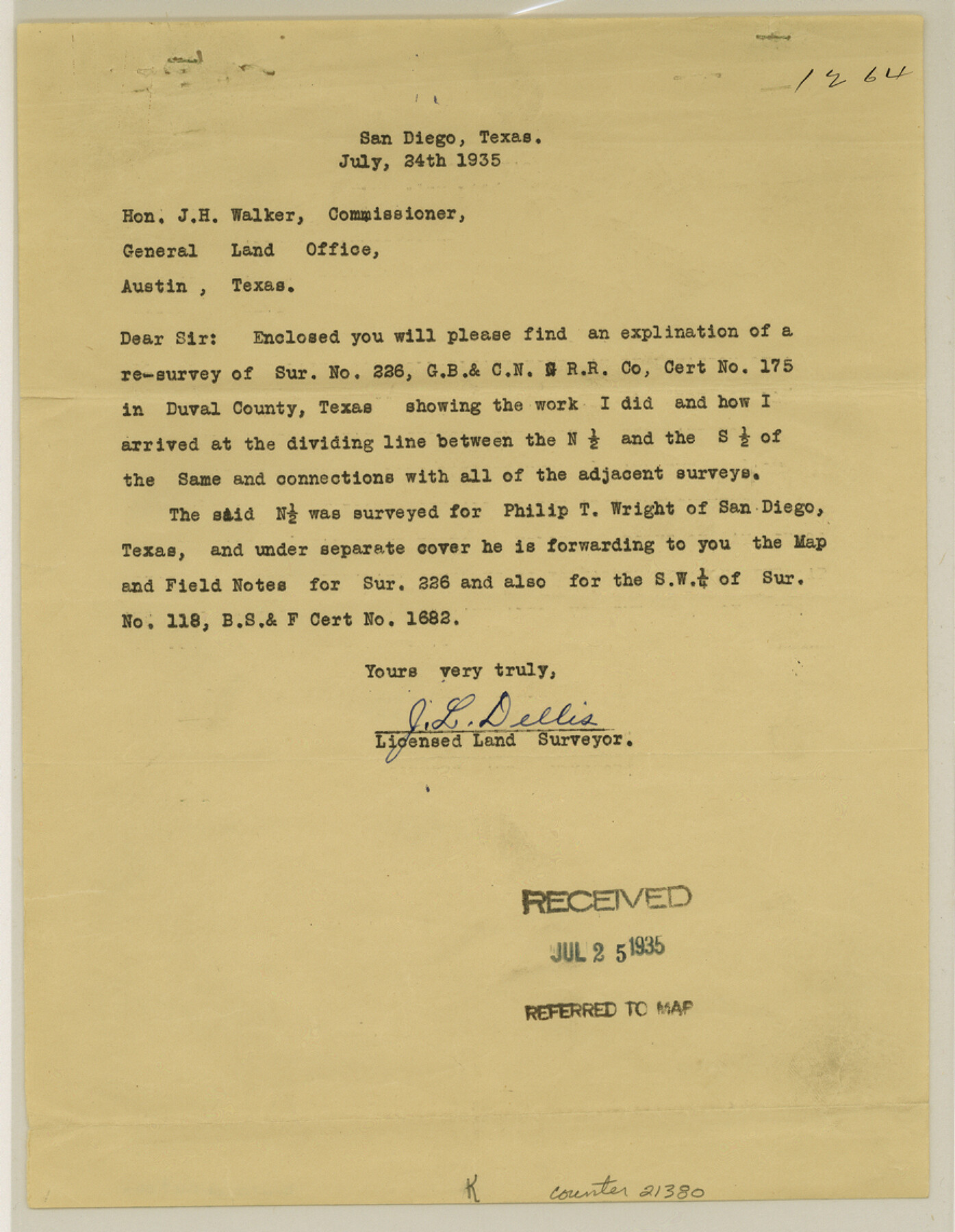
Duval County Sketch File 36a
[Explanation of resurvey of survey 226, G. B. & C. N. G. RR. Co.]
-
Map/Doc
21380
-
Collection
General Map Collection
-
Object Dates
1935/7/24 (Creation Date)
1935/7/25 (File Date)
-
People and Organizations
J.S. Boyles (Surveyor/Engineer)
J.L. Dellis (Surveyor/Engineer)
Hayes Dix (Surveyor/Engineer)
John J. Dix (Surveyor/Engineer)
-
Counties
Duval
-
Subjects
Surveying Sketch File
-
Height x Width
11.4 x 8.8 inches
29.0 x 22.4 cm
-
Medium
paper, print
-
Features
Public Road
Part of: General Map Collection
Flight Mission No. DQN-5K, Frame 52, Calhoun County

Print $20.00
- Digital $50.00
Flight Mission No. DQN-5K, Frame 52, Calhoun County
1953
Size 18.6 x 22.3 inches
Map/Doc 84397
Maverick County Sketch File 16a

Print $9.00
- Digital $50.00
Maverick County Sketch File 16a
1886
Size 9.5 x 13.7 inches
Map/Doc 31117
Haskell County

Print $20.00
- Digital $50.00
Haskell County
1879
Size 21.0 x 20.4 inches
Map/Doc 1127
Brazoria County Sketch File 15

Print $4.00
- Digital $50.00
Brazoria County Sketch File 15
1892
Size 12.8 x 8.4 inches
Map/Doc 14977
Flight Mission No. BRE-3P, Frame 93, Nueces County

Print $20.00
- Digital $50.00
Flight Mission No. BRE-3P, Frame 93, Nueces County
1956
Size 18.6 x 22.6 inches
Map/Doc 86824
Flight Mission No. DIX-3P, Frame 138, Aransas County

Print $20.00
- Digital $50.00
Flight Mission No. DIX-3P, Frame 138, Aransas County
1956
Size 17.7 x 18.6 inches
Map/Doc 83768
Runnels County Sketch File 17

Print $6.00
Runnels County Sketch File 17
Size 11.0 x 13.6 inches
Map/Doc 35474
Starr County Working Sketch 19

Print $20.00
- Digital $50.00
Starr County Working Sketch 19
1982
Size 27.3 x 33.9 inches
Map/Doc 63935
Rusk County Sketch File 46

Print $4.00
Rusk County Sketch File 46
1846
Size 12.6 x 7.8 inches
Map/Doc 35595
Flight Mission No. DCL-7C, Frame 116, Kenedy County

Print $20.00
- Digital $50.00
Flight Mission No. DCL-7C, Frame 116, Kenedy County
1943
Size 18.6 x 22.4 inches
Map/Doc 86081
Stephens County Sketch File 8

Print $40.00
- Digital $50.00
Stephens County Sketch File 8
1879
Size 13.5 x 14.2 inches
Map/Doc 37027
Starr County Sketch File 34

Print $20.00
- Digital $50.00
Starr County Sketch File 34
1939
Size 15.8 x 17.6 inches
Map/Doc 12337
You may also like
Presidio County Sketch File 29

Print $20.00
- Digital $50.00
Presidio County Sketch File 29
1890
Size 29.7 x 20.1 inches
Map/Doc 11711
Rusk County Working Sketch 20b

Print $20.00
- Digital $50.00
Rusk County Working Sketch 20b
1955
Size 31.5 x 30.3 inches
Map/Doc 63656
Schleicher County Rolled Sketch 9

Print $20.00
- Digital $50.00
Schleicher County Rolled Sketch 9
Size 22.7 x 22.0 inches
Map/Doc 7751
Highway Map State of Texas

Print $20.00
Highway Map State of Texas
1919
Size 31.9 x 33.1 inches
Map/Doc 76291
Scurry County Working Sketch Graphic Index

Print $20.00
- Digital $50.00
Scurry County Working Sketch Graphic Index
1921
Size 39.9 x 37.0 inches
Map/Doc 76695
Panola County Working Sketch 11

Print $20.00
- Digital $50.00
Panola County Working Sketch 11
1944
Map/Doc 71420
Young County Sketch File 17

Print $20.00
- Digital $50.00
Young County Sketch File 17
Size 18.5 x 24.3 inches
Map/Doc 12713
Val Verde County Sketch File A

Print $20.00
- Digital $50.00
Val Verde County Sketch File A
1878
Size 25.6 x 16.0 inches
Map/Doc 12538
Kent County Working Sketch 4

Print $20.00
- Digital $50.00
Kent County Working Sketch 4
1948
Size 27.9 x 25.8 inches
Map/Doc 70011
Dickens County, Texas

Print $20.00
- Digital $50.00
Dickens County, Texas
Size 33.7 x 39.8 inches
Map/Doc 92588
Bowie County Sketch File 8c

Print $32.00
- Digital $50.00
Bowie County Sketch File 8c
1928
Size 8.1 x 5.3 inches
Map/Doc 14878
Ector County Working Sketch 19

Print $40.00
- Digital $50.00
Ector County Working Sketch 19
1958
Size 65.8 x 37.6 inches
Map/Doc 68862