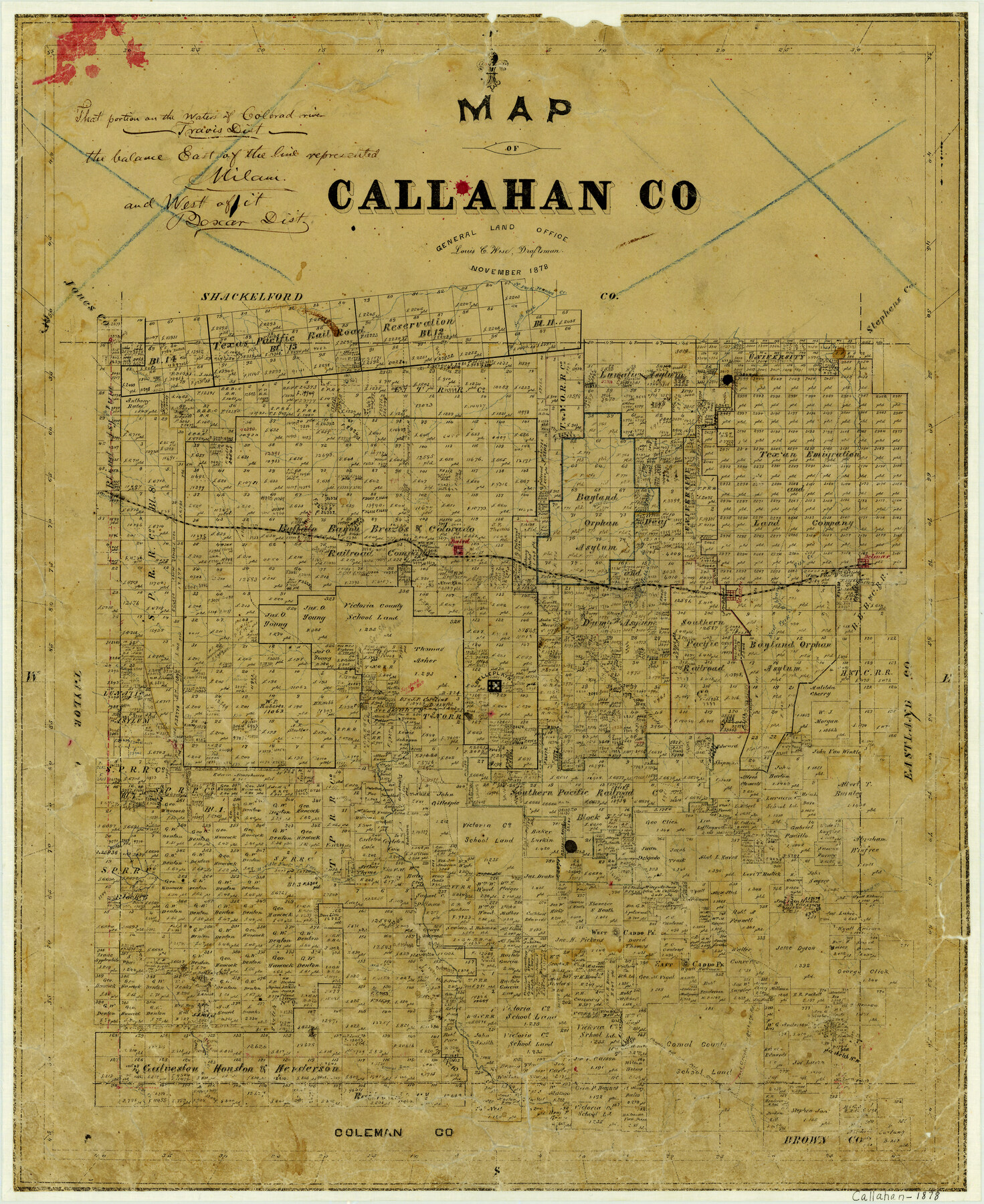
Map of Callahan County
-
Map/Doc
3361
-
Collection
General Map Collection
-
Object Dates
11/1878 (Creation Date)
-
People and Organizations
Louis C. Wise (Draftsman)
-
Counties
Callahan
-
Subjects
County
-
Height x Width
23.0 x 18.8 inches
58.4 x 47.8 cm
-
Features
Mayne's Creek
Burnt Creek
Jim Ned Creek
Greenbrier Creek
Phantom Hill Road
Phantom Hill and Fort Croghan Road
Belknap Road
Fort Croghan Road
Fort Croghan and Belknap Road
East Caddo Peak
Barren Creek
Big Tecumseh P[eak]
Little Tecumseh P[eak]
Middle Fork of Pecan Bayou
West Caddo Peak
North Fork of Jennie's Creek
Turkey Creek
Belleplain [sic]
Live Oak Creek
Baird
West Fork of Hubbard's Creek
Bremen
East Fork of Hubbard's Creek
Fish Creek
Delmar
Deep Creek
Raines Creek
Big [ ] Creek
Deadman's Creek
South Fork of Jennie's Creek
Part of: General Map Collection
McMullen County Sketch File 16a

Print $40.00
- Digital $50.00
McMullen County Sketch File 16a
Size 12.5 x 12.5 inches
Map/Doc 31367
Kinney County Rolled Sketch 3

Print $20.00
- Digital $50.00
Kinney County Rolled Sketch 3
Size 31.4 x 23.2 inches
Map/Doc 6535
Cameron County Sketch File 14

Print $38.00
- Digital $50.00
Cameron County Sketch File 14
1993
Size 11.2 x 8.8 inches
Map/Doc 17311
Flight Mission No. DAH-9M, Frame 202, Orange County

Print $20.00
- Digital $50.00
Flight Mission No. DAH-9M, Frame 202, Orange County
1953
Size 18.5 x 22.6 inches
Map/Doc 86870
Flight Mission No. DQO-1K, Frame 154, Galveston County

Print $20.00
- Digital $50.00
Flight Mission No. DQO-1K, Frame 154, Galveston County
1952
Size 18.8 x 22.5 inches
Map/Doc 85007
Panola County Rolled Sketch 1

Print $20.00
- Digital $50.00
Panola County Rolled Sketch 1
Size 17.5 x 23.9 inches
Map/Doc 7196
Roberts County Working Sketch 24

Print $20.00
- Digital $50.00
Roberts County Working Sketch 24
1981
Size 25.8 x 36.9 inches
Map/Doc 63550
Karnes County Boundary File 6

Print $16.00
- Digital $50.00
Karnes County Boundary File 6
Size 9.3 x 4.0 inches
Map/Doc 55735
Frio County Working Sketch 21

Print $20.00
- Digital $50.00
Frio County Working Sketch 21
1985
Size 46.1 x 43.5 inches
Map/Doc 69295
Brown County Working Sketch 15

Print $20.00
- Digital $50.00
Brown County Working Sketch 15
1989
Size 23.6 x 16.7 inches
Map/Doc 67780
Bosque County, Milam District

Print $20.00
- Digital $50.00
Bosque County, Milam District
1876
Size 24.0 x 29.1 inches
Map/Doc 1519

You may also like
Van Zandt County Sketch File 22

Print $6.00
- Digital $50.00
Van Zandt County Sketch File 22
Size 8.6 x 7.8 inches
Map/Doc 39432
Flight Mission No. DIX-8P, Frame 70, Aransas County

Print $20.00
- Digital $50.00
Flight Mission No. DIX-8P, Frame 70, Aransas County
1956
Size 18.7 x 22.4 inches
Map/Doc 83901
Map of Cherokee County

Print $20.00
- Digital $50.00
Map of Cherokee County
1848
Size 27.1 x 20.6 inches
Map/Doc 3390
Washington County Sketch File 3

Print $4.00
- Digital $50.00
Washington County Sketch File 3
1860
Size 8.1 x 9.2 inches
Map/Doc 39648
Gregg County Rolled Sketch 7A

Print $20.00
- Digital $50.00
Gregg County Rolled Sketch 7A
1932
Size 22.6 x 39.2 inches
Map/Doc 6033
Packery Channel

Print $20.00
- Digital $50.00
Packery Channel
1975
Size 18.6 x 46.2 inches
Map/Doc 3004
Angelina County Working Sketch 35

Print $20.00
- Digital $50.00
Angelina County Working Sketch 35
1957
Size 27.4 x 29.6 inches
Map/Doc 67118
Map of Survey in Dimmit and Webb Counties

Print $40.00
- Digital $50.00
Map of Survey in Dimmit and Webb Counties
1913
Size 31.2 x 69.2 inches
Map/Doc 75828
Vicinity of San Luis Pass, Galveston Island, Texas

Print $40.00
- Digital $50.00
Vicinity of San Luis Pass, Galveston Island, Texas
1933
Size 37.1 x 57.8 inches
Map/Doc 69943
El Paso County Rolled Sketch LH

Print $20.00
- Digital $50.00
El Paso County Rolled Sketch LH
1890
Size 20.3 x 31.7 inches
Map/Doc 5858
Van Zandt County Boundary File 1

Print $32.00
- Digital $50.00
Van Zandt County Boundary File 1
Size 13.0 x 8.5 inches
Map/Doc 59626
Williamson County Working Sketch 3

Print $20.00
- Digital $50.00
Williamson County Working Sketch 3
1915
Size 17.9 x 20.2 inches
Map/Doc 72563