El Paso County Sketch File 35 (2)
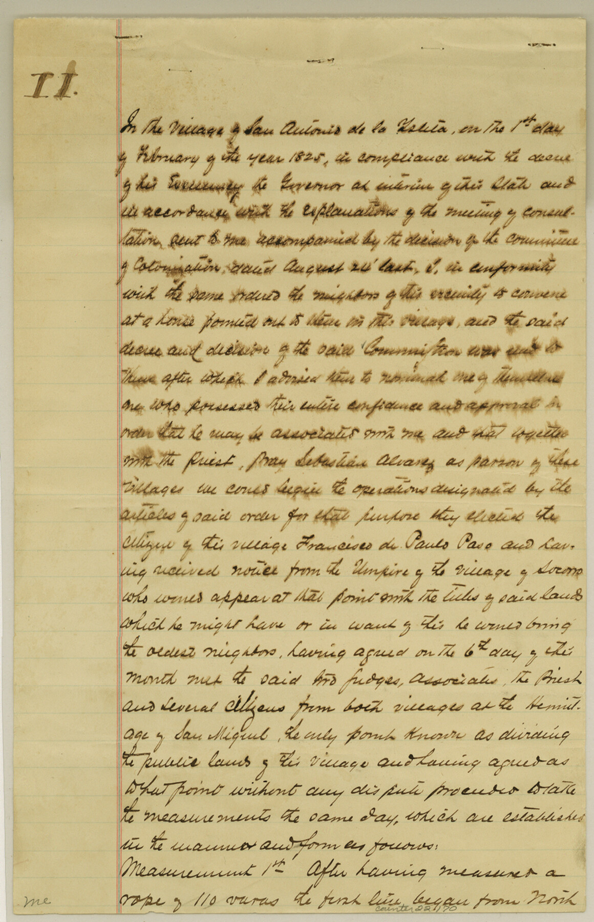
[Copy of case no. 99, Pueblo of Seneca vs. Town of Ysleta, description of meaurements for division line]
-
Map/Doc
22170
-
Collection
General Map Collection
-
Object Dates
3/19/1886 (Creation Date)
12/12/1984 (File Date)
1825 (Survey Date)
-
Counties
El Paso
-
Subjects
Surveying Sketch File
-
Height x Width
12.9 x 8.3 inches
32.8 x 21.1 cm
-
Medium
paper, manuscript
-
Comments
See related: El Paso County Sketch Files 35 (22161), 35(1) (22166), 35(3) (22179), 35(4) (22199), 35(5) (22218), 35(6) (11460)
Formerly filed as Letter File 194001 ½ -
Features
San Antonio de la Ysleta
Hermitage of San Miguel
Socorro
Ysleta
Clay
Salama [Springs]
Negro Hill
Colorado Hill
Apodeca Hill
Figua Hill
Sabino Hill
San Antonio de Sevian
San Antonio de Ysleta
Mission of Severn
Seneca Pueblo
Related maps
El Paso County Sketch File 35 (6)

Print $20.00
- Digital $50.00
El Paso County Sketch File 35 (6)
1886
Size 20.3 x 36.9 inches
Map/Doc 11460
El Paso County Sketch File 35

Print $10.00
- Digital $50.00
El Paso County Sketch File 35
1886
Size 11.3 x 8.9 inches
Map/Doc 22161
El Paso County Sketch File 35 (1)

Print $8.00
- Digital $50.00
El Paso County Sketch File 35 (1)
Size 13.0 x 8.3 inches
Map/Doc 22166
El Paso County Sketch File 35 (3)

Print $40.00
- Digital $50.00
El Paso County Sketch File 35 (3)
1886
Size 12.8 x 8.3 inches
Map/Doc 22179
El Paso County Sketch File 35 (4)

Print $38.00
- Digital $50.00
El Paso County Sketch File 35 (4)
1886
Size 14.3 x 9.0 inches
Map/Doc 22199
El Paso County Sketch File 35 (5)

Print $6.00
- Digital $50.00
El Paso County Sketch File 35 (5)
1886
Size 14.6 x 8.9 inches
Map/Doc 22218
Part of: General Map Collection
Starr County Boundary File 1a

Print $20.00
- Digital $50.00
Starr County Boundary File 1a
Size 22.4 x 41.0 inches
Map/Doc 58813
Upton County Working Sketch 40

Print $40.00
- Digital $50.00
Upton County Working Sketch 40
1959
Size 37.5 x 63.7 inches
Map/Doc 69536
Upton County Rolled Sketch 39

Print $40.00
- Digital $50.00
Upton County Rolled Sketch 39
Size 53.4 x 44.1 inches
Map/Doc 10055
Flight Mission No. DQO-1K, Frame 92, Galveston County

Print $20.00
- Digital $50.00
Flight Mission No. DQO-1K, Frame 92, Galveston County
1952
Size 18.9 x 22.6 inches
Map/Doc 84988
Sterling County Rolled Sketch 21

Print $20.00
- Digital $50.00
Sterling County Rolled Sketch 21
Size 29.6 x 23.8 inches
Map/Doc 7849
Flight Mission No. DQO-3K, Frame 22, Galveston County

Print $20.00
- Digital $50.00
Flight Mission No. DQO-3K, Frame 22, Galveston County
1952
Size 18.8 x 22.5 inches
Map/Doc 85063
Gray County Rolled Sketch A

Print $20.00
- Digital $50.00
Gray County Rolled Sketch A
1888
Size 40.4 x 40.8 inches
Map/Doc 9008

Presidio County Working Sketch 73

Print $20.00
- Digital $50.00
Presidio County Working Sketch 73
1962
Size 17.7 x 29.4 inches
Map/Doc 71750
Map of Texas and Adjacent Regions in the Eighteenth Century

Print $20.00
- Digital $50.00
Map of Texas and Adjacent Regions in the Eighteenth Century
1915
Size 16.7 x 20.0 inches
Map/Doc 94007
Brewster County Working Sketch 92

Print $40.00
- Digital $50.00
Brewster County Working Sketch 92
1975
Size 61.9 x 39.4 inches
Map/Doc 67692
Western Territories of the United States

Print $20.00
- Digital $50.00
Western Territories of the United States
1847
Size 12.1 x 19.0 inches
Map/Doc 93543
You may also like
Culberson County Working Sketch 31

Print $20.00
- Digital $50.00
Culberson County Working Sketch 31
1958
Size 30.5 x 30.0 inches
Map/Doc 68484
Coleman County Sketch File 15

Print $4.00
- Digital $50.00
Coleman County Sketch File 15
1848
Size 7.3 x 13.0 inches
Map/Doc 18681
Bastrop County Sketch File 3

Print $4.00
- Digital $50.00
Bastrop County Sketch File 3
1860
Size 8.9 x 9.2 inches
Map/Doc 14044
Aransas County Sketch File 18

Print $8.00
- Digital $50.00
Aransas County Sketch File 18
1888
Size 12.7 x 8.2 inches
Map/Doc 13149
Milam County Boundary File 5b

Print $20.00
- Digital $50.00
Milam County Boundary File 5b
Size 22.6 x 37.8 inches
Map/Doc 57239
Geological Map of the route explored by Lieut. A.W. Whipple, Corps of Topl. Engrs. near the Parallel of 35° North Latitude from the Mississippi River to the Pacific Ocean 1853-1854

Print $20.00
- Digital $50.00
Geological Map of the route explored by Lieut. A.W. Whipple, Corps of Topl. Engrs. near the Parallel of 35° North Latitude from the Mississippi River to the Pacific Ocean 1853-1854
1854
Size 11.2 x 39.3 inches
Map/Doc 95750
McMullen County Sketch File 47

Print $20.00
- Digital $50.00
McMullen County Sketch File 47
1989
Size 24.6 x 21.5 inches
Map/Doc 12066
Bailey County Rolled Sketch R and C

Print $51.00
- Digital $50.00
Bailey County Rolled Sketch R and C
1913
Size 10.1 x 16.0 inches
Map/Doc 42350
Colorado County Sketch File 29

Print $6.00
- Digital $50.00
Colorado County Sketch File 29
1842
Size 11.2 x 9.0 inches
Map/Doc 18974
[Sketch of Blocks Z and 194, showing tie lines with Runnels County School Land survey]
![91665, [Sketch of Blocks Z and 194, showing tie lines with Runnels County School Land survey], Twichell Survey Records](https://historictexasmaps.com/wmedia_w700/maps/91665-1.tif.jpg)
Print $20.00
- Digital $50.00
[Sketch of Blocks Z and 194, showing tie lines with Runnels County School Land survey]
Size 21.5 x 15.5 inches
Map/Doc 91665

Current Miscellaneous File 65

Print $8.00
- Digital $50.00
Current Miscellaneous File 65
Size 11.2 x 8.6 inches
Map/Doc 74109