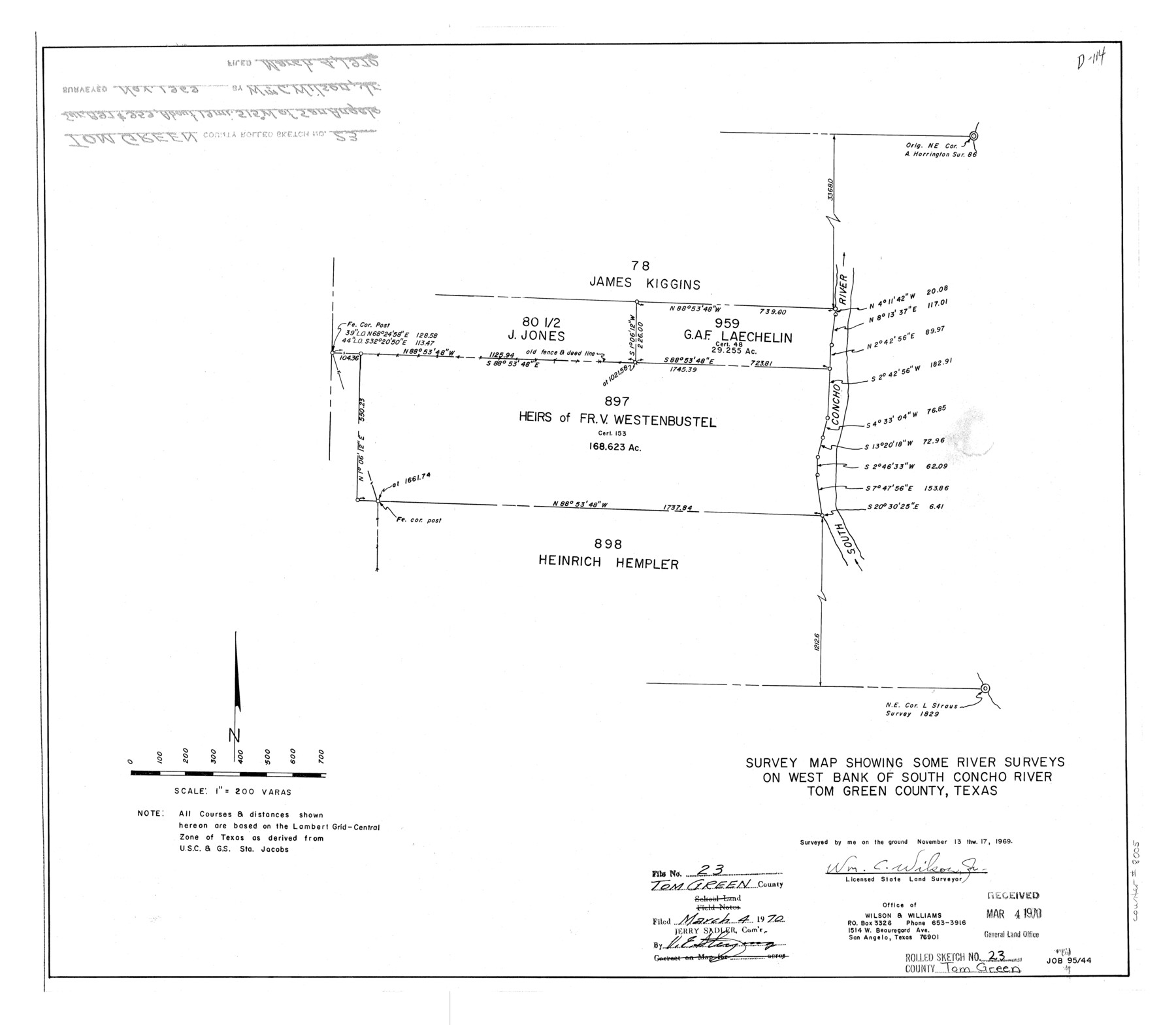
Tom Green County Rolled Sketch 23
Survey map showing some river surveys on west bank of South Concho River, Tom Green County, Texas
-
Map/Doc
8005
-
Collection
General Map Collection
-
Object Dates
1969/11/17 (Survey Date)
1970/3/4 (File Date)
-
People and Organizations
Wm. C. Wilson, Jr. (Surveyor/Engineer)
-
Counties
Tom Green
-
Subjects
Surveying Rolled Sketch
-
Height x Width
19.1 x 21.9 inches
48.5 x 55.6 cm
-
Scale
1" = 200 varas
Related maps
Tom Green County Sketch File 79A

Print $4.00
- Digital $50.00
Tom Green County Sketch File 79A
1970
Size 14.5 x 8.8 inches
Map/Doc 38258
Part of: General Map Collection
PSL Field Notes for Blocks 87 through 98 in Culberson County

PSL Field Notes for Blocks 87 through 98 in Culberson County
Map/Doc 81664
Reagan County Working Sketch 42

Print $20.00
- Digital $50.00
Reagan County Working Sketch 42
1973
Size 19.9 x 37.0 inches
Map/Doc 71884
[Maps of surveys in Reeves & Culberson Cos]
![61131, [Maps of surveys in Reeves & Culberson Cos], General Map Collection](https://historictexasmaps.com/wmedia_w700/maps/61131.tif.jpg)
Print $20.00
- Digital $50.00
[Maps of surveys in Reeves & Culberson Cos]
1937
Size 30.6 x 24.8 inches
Map/Doc 61131
South Part of Brewster Co.

Print $40.00
- Digital $50.00
South Part of Brewster Co.
1955
Size 49.3 x 41.3 inches
Map/Doc 66735
El Paso County Working Sketch 56

Print $40.00
- Digital $50.00
El Paso County Working Sketch 56
1971
Size 65.7 x 43.4 inches
Map/Doc 69078
Polk County Sketch File 29

Print $4.00
- Digital $50.00
Polk County Sketch File 29
Size 8.8 x 12.6 inches
Map/Doc 34200
Map of the State of Texas

Print $40.00
- Digital $50.00
Map of the State of Texas
1879
Size 102.3 x 57.5 inches
Map/Doc 93385
Collingsworth County Rolled Sketch 1

Print $40.00
- Digital $50.00
Collingsworth County Rolled Sketch 1
1941
Size 58.0 x 27.0 inches
Map/Doc 8637
The Railroad System of Texas on September 1st, 1887

Print $20.00
- Digital $50.00
The Railroad System of Texas on September 1st, 1887
1887
Size 22.2 x 28.2 inches
Map/Doc 3036
Upton County Working Sketch 19

Print $40.00
- Digital $50.00
Upton County Working Sketch 19
1949
Size 51.7 x 43.3 inches
Map/Doc 69515
Bowie County Working Sketch 11

Print $20.00
- Digital $50.00
Bowie County Working Sketch 11
1958
Size 43.2 x 31.6 inches
Map/Doc 67415
Lubbock County Working Sketch 6

Print $20.00
- Digital $50.00
Lubbock County Working Sketch 6
1959
Size 25.1 x 22.4 inches
Map/Doc 70666
You may also like
Montgomery County Sketch File 26

Print $6.00
- Digital $50.00
Montgomery County Sketch File 26
1845
Size 13.4 x 11.4 inches
Map/Doc 31871
Lavaca County Sketch File 1

Print $4.00
- Digital $50.00
Lavaca County Sketch File 1
1848
Size 12.7 x 8.2 inches
Map/Doc 29628
Armstrong County Sketch File B

Print $26.00
- Digital $50.00
Armstrong County Sketch File B
1903
Size 14.2 x 8.5 inches
Map/Doc 13669
The Principal Transportation Lines west of Chicago, St. Louis, & New Orleans, to accompany the report on the Internal Commerce of the United States for 1880

Print $20.00
- Digital $50.00
The Principal Transportation Lines west of Chicago, St. Louis, & New Orleans, to accompany the report on the Internal Commerce of the United States for 1880
1880
Size 26.7 x 22.7 inches
Map/Doc 95906
Current Miscellaneous File 46

Print $4.00
- Digital $50.00
Current Miscellaneous File 46
1954
Size 10.7 x 8.2 inches
Map/Doc 73990
Montgomery County Sketch File 18

Print $20.00
- Digital $50.00
Montgomery County Sketch File 18
1899
Size 22.1 x 19.6 inches
Map/Doc 42122
Fractional Township No. 7 South Range No. 3 East of the Indian Meridian, Indian Territory

Print $20.00
- Digital $50.00
Fractional Township No. 7 South Range No. 3 East of the Indian Meridian, Indian Territory
1898
Size 19.2 x 24.3 inches
Map/Doc 75206
Jefferson County Rolled Sketch 60

Print $20.00
- Digital $50.00
Jefferson County Rolled Sketch 60
1885
Size 31.0 x 35.6 inches
Map/Doc 9315
Trinity River, Boyd Crossing Sheet/Chambers Creek

Print $20.00
- Digital $50.00
Trinity River, Boyd Crossing Sheet/Chambers Creek
1931
Size 17.5 x 43.1 inches
Map/Doc 65238

Atascosa County Sketch File 27a

Print $4.00
- Digital $50.00
Atascosa County Sketch File 27a
Size 8.4 x 14.3 inches
Map/Doc 13799
Wilson Strickland Survey, Exhibit A

Print $20.00
- Digital $50.00
Wilson Strickland Survey, Exhibit A
Size 20.8 x 23.0 inches
Map/Doc 91368