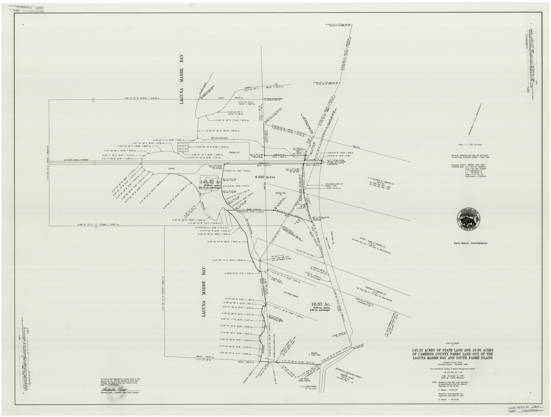
Cameron County Rolled Sketch 28A
Plat of survey of 145.32 acres of State Land and 16.65 acres of Cameron County Parks land out of the Laguna Madre Bay and South Padre Islands
-
Map/Doc
8576
-
Collection
General Map Collection
-
Object Dates
12/12/1986 (Creation Date)
1991 (File Date)
2/1/1991 (Revision Date)
10 - 11/1986 (Survey Date)
-
People and Organizations
Elisandro Leos (Surveyor/Engineer)
S. Segura (Draftsman)
John Austin Williamson (Draftsman)
-
Counties
Cameron
-
Subjects
Surveying Rolled Sketch
-
Height x Width
36.0 x 47.6 inches
91.4 x 120.9 cm
-
Medium
mylar, print
-
Scale
1" = 100 feet or 36 varas
-
Comments
See Cameron County Rolled Sketch 28 (8575), Cameron County Rolled Sketch 28B (8577), and Cameron County Rolled Sketch 28C (5393) for related and/or updated sketches.
Related maps
Cameron County Rolled Sketch 28C

Print $20.00
- Digital $50.00
Cameron County Rolled Sketch 28C
Size 20.3 x 16.3 inches
Map/Doc 5393
Cameron County Rolled Sketch 28

Print $40.00
- Digital $50.00
Cameron County Rolled Sketch 28
1986
Size 36.5 x 48.3 inches
Map/Doc 8575
Cameron County Rolled Sketch 28B

Print $40.00
- Digital $50.00
Cameron County Rolled Sketch 28B
1986
Size 36.9 x 48.3 inches
Map/Doc 8577
Part of: General Map Collection
Harris County Sketch File 110

Print $26.00
- Digital $50.00
Harris County Sketch File 110
2009
Size 11.0 x 8.5 inches
Map/Doc 89586
Flight Mission No. DCL-6C, Frame 70, Kenedy County

Print $20.00
- Digital $50.00
Flight Mission No. DCL-6C, Frame 70, Kenedy County
1943
Size 18.6 x 22.3 inches
Map/Doc 85912
Harrison County Working Sketch 34

Print $20.00
- Digital $50.00
Harrison County Working Sketch 34
2015
Size 13.7 x 17.9 inches
Map/Doc 93726
Hardeman County Working Sketch 10

Print $20.00
- Digital $50.00
Hardeman County Working Sketch 10
1960
Size 21.9 x 29.9 inches
Map/Doc 63391
Wheeler County Working Sketch 6

Print $40.00
- Digital $50.00
Wheeler County Working Sketch 6
1972
Size 49.8 x 47.4 inches
Map/Doc 72495
[Letter regarding surveys in Coryell County]
![69754, [Letter regarding surveys in Coryell County], General Map Collection](https://historictexasmaps.com/wmedia_w700/maps/69754.tif.jpg)
Print $2.00
- Digital $50.00
[Letter regarding surveys in Coryell County]
1846
Size 7.7 x 6.4 inches
Map/Doc 69754
Flight Mission No. BRE-1P, Frame 49, Nueces County

Print $20.00
- Digital $50.00
Flight Mission No. BRE-1P, Frame 49, Nueces County
1956
Size 18.4 x 22.2 inches
Map/Doc 86638
Harris County Sketch File 30

Print $21.00
- Digital $50.00
Harris County Sketch File 30
Size 11.3 x 8.5 inches
Map/Doc 25416
![94158, Austin Street Map [Recto], General Map Collection](https://historictexasmaps.com/wmedia_w700/maps/94158.tif.jpg)
Culberson County Working Sketch 34

Print $20.00
- Digital $50.00
Culberson County Working Sketch 34
1962
Size 35.2 x 26.0 inches
Map/Doc 68487
Nueces County Rolled Sketch 32

Print $20.00
- Digital $50.00
Nueces County Rolled Sketch 32
Size 17.0 x 17.2 inches
Map/Doc 6876
Upper Galveston Bay, Houston Ship Channel, Dollar Pt. to Atkinson I.

Print $40.00
- Digital $50.00
Upper Galveston Bay, Houston Ship Channel, Dollar Pt. to Atkinson I.
1971
Size 49.3 x 36.4 inches
Map/Doc 69894
You may also like
Hardeman County Sketch File 4

Print $6.00
- Digital $50.00
Hardeman County Sketch File 4
Size 9.3 x 8.2 inches
Map/Doc 24991
Flight Mission No. DAG-19K, Frame 58, Matagorda County

Print $20.00
- Digital $50.00
Flight Mission No. DAG-19K, Frame 58, Matagorda County
1952
Size 18.5 x 16.3 inches
Map/Doc 86385
Galveston County Rolled Sketch JR

Print $20.00
- Digital $50.00
Galveston County Rolled Sketch JR
1938
Size 37.5 x 36.7 inches
Map/Doc 9086
Flight Mission No. DQN-2K, Frame 31, Calhoun County

Print $20.00
- Digital $50.00
Flight Mission No. DQN-2K, Frame 31, Calhoun County
1953
Size 18.7 x 22.3 inches
Map/Doc 84238

Railroad map of the state of Texas / compiled and engraved expressly for the American railroad manual.

Print $20.00
Railroad map of the state of Texas / compiled and engraved expressly for the American railroad manual.
1873
Size 13.4 x 9.5 inches
Map/Doc 93599
Map of the East Part of Tom Green County

Print $40.00
- Digital $50.00
Map of the East Part of Tom Green County
1894
Size 45.9 x 49.4 inches
Map/Doc 63071
Northern Part of Laguna Madre
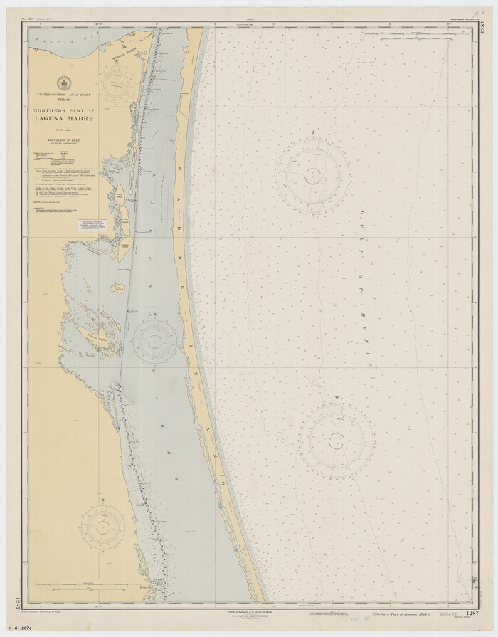
Print $20.00
- Digital $50.00
Northern Part of Laguna Madre
1949
Size 44.6 x 34.9 inches
Map/Doc 73524
Nueces County Rolled Sketch 2

Print $20.00
- Digital $50.00
Nueces County Rolled Sketch 2
1907
Size 18.4 x 35.8 inches
Map/Doc 6865
Motley County Sketch File 6 (N)

Print $20.00
- Digital $50.00
Motley County Sketch File 6 (N)
1900
Size 14.0 x 8.6 inches
Map/Doc 32004
Map of Augustine Cty.

Print $20.00
- Digital $50.00
Map of Augustine Cty.
1839
Size 22.9 x 14.6 inches
Map/Doc 165
Bosque County Sketch File 28

Print $6.00
- Digital $50.00
Bosque County Sketch File 28
1888
Size 7.3 x 10.3 inches
Map/Doc 14813