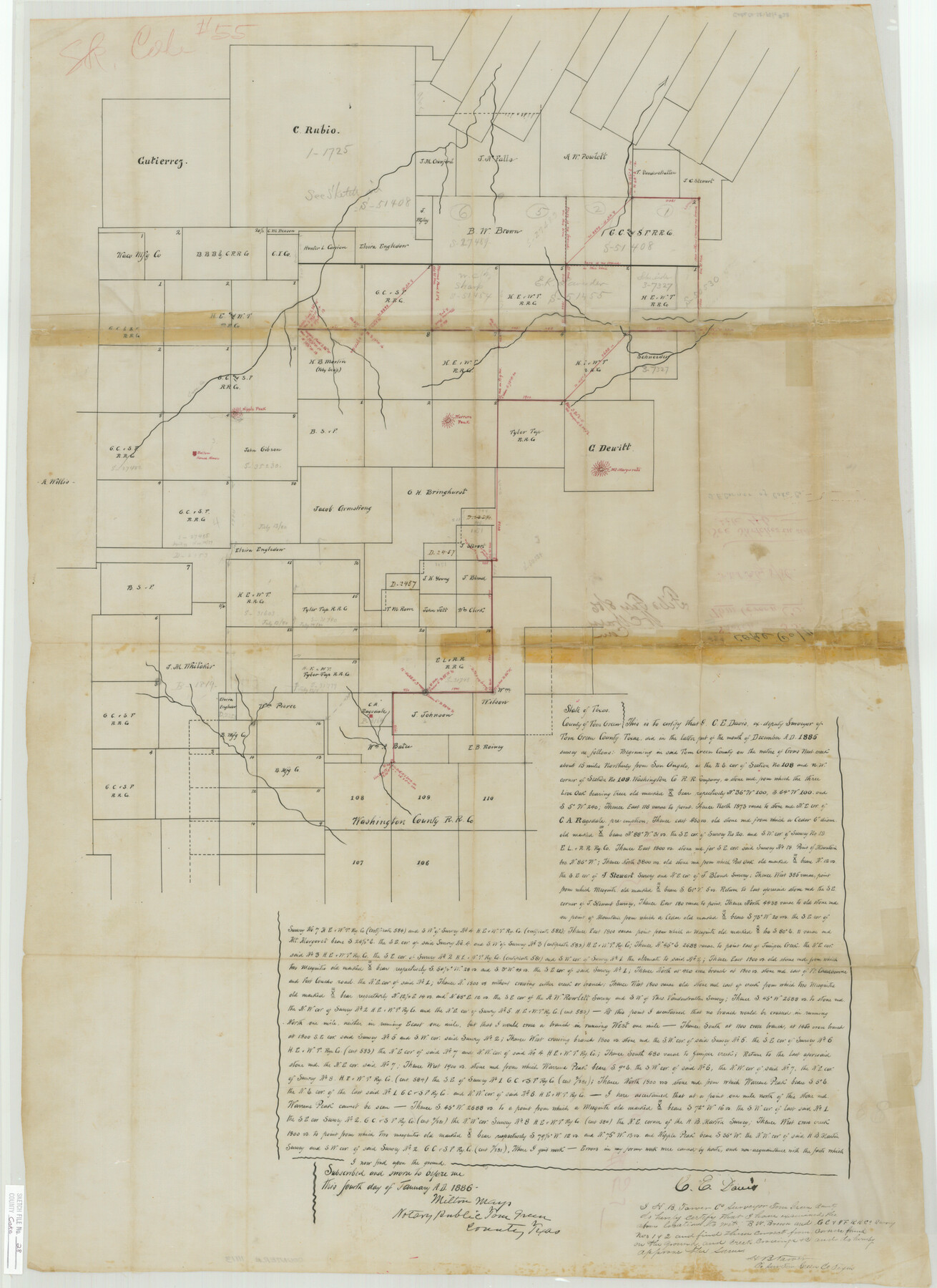
Coke County Sketch File 28
[Field notes and sketch of large area in southeast corner of Coke County and northeast corner of Tom Green County]
-
Map/Doc
11113
-
Collection
General Map Collection
-
Object Dates
1886/1/4 (Creation Date)
1886/2/8 (File Date)
1885 (Survey Date)
-
People and Organizations
C.E. Davis (Surveyor/Engineer)
-
Counties
Coke Tom Green
-
Subjects
Surveying Sketch File
-
Height x Width
36.4 x 26.5 inches
92.5 x 67.3 cm
-
Medium
paper, manuscript
-
Features
Warrens Peak
Nipple Peak
Belton Ranch House
Mt. Margarett
Crows Nest Creek
San Angelo
Fort Chadbourne
Fort Concho
Part of: General Map Collection
McMullen County Working Sketch 32

Print $20.00
- Digital $50.00
McMullen County Working Sketch 32
1958
Size 28.2 x 32.5 inches
Map/Doc 70733
Armstrong County, State of Texas

Print $20.00
- Digital $50.00
Armstrong County, State of Texas
1888
Size 22.6 x 18.2 inches
Map/Doc 3245
Map of Wise County

Print $20.00
- Digital $50.00
Map of Wise County
1895
Size 41.8 x 37.2 inches
Map/Doc 16932
Liberty County Working Sketch 30

Print $20.00
- Digital $50.00
Liberty County Working Sketch 30
1943
Size 18.5 x 20.6 inches
Map/Doc 70489
Coke County Working Sketch 17

Print $20.00
- Digital $50.00
Coke County Working Sketch 17
1948
Size 18.2 x 19.4 inches
Map/Doc 68054
No. 3 Chart of Channel connecting Corpus Christi Bay with Aransas Bay, Texas

Print $20.00
- Digital $50.00
No. 3 Chart of Channel connecting Corpus Christi Bay with Aransas Bay, Texas
1878
Size 18.4 x 28.0 inches
Map/Doc 72775
Edwards County Working Sketch 36

Print $20.00
- Digital $50.00
Edwards County Working Sketch 36
1948
Size 46.7 x 44.5 inches
Map/Doc 68912
Brazoria County NRC Article 33.136 Sketch 31

Print $24.00
Brazoria County NRC Article 33.136 Sketch 31
2025
Map/Doc 97476
San Jacinto County Working Sketch 8
Print $20.00
- Digital $50.00
San Jacinto County Working Sketch 8
1935
Size 38.4 x 42.9 inches
Map/Doc 63721
Maverick County Working Sketch 20

Print $20.00
- Digital $50.00
Maverick County Working Sketch 20
1977
Size 26.1 x 22.0 inches
Map/Doc 70912
Kerr County Rolled Sketch 18

Print $20.00
- Digital $50.00
Kerr County Rolled Sketch 18
1954
Size 33.4 x 28.8 inches
Map/Doc 6500
Archer County Sketch File 31

Print $8.00
- Digital $50.00
Archer County Sketch File 31
2012
Size 11.0 x 8.5 inches
Map/Doc 93322
You may also like
Chambers County NRC Article 33.136 Sketch 7

Print $28.00
- Digital $50.00
Chambers County NRC Article 33.136 Sketch 7
2011
Size 18.0 x 24.0 inches
Map/Doc 94753
Glasscock County Sketch File 3

Print $3.00
- Digital $50.00
Glasscock County Sketch File 3
1931
Size 11.1 x 14.8 inches
Map/Doc 11560
Scurry County Rolled Sketch 3

Print $40.00
- Digital $50.00
Scurry County Rolled Sketch 3
Size 50.2 x 46.7 inches
Map/Doc 9912
[B. S. & F. Blocks 1 and 6, A. B. & M. Block 2 and surrounding surveys and blocks]
![91785, [B. S. & F. Blocks 1 and 6, A. B. & M. Block 2 and surrounding surveys and blocks], Twichell Survey Records](https://historictexasmaps.com/wmedia_w700/maps/91785-1.tif.jpg)
Print $20.00
- Digital $50.00
[B. S. & F. Blocks 1 and 6, A. B. & M. Block 2 and surrounding surveys and blocks]
Size 22.6 x 33.8 inches
Map/Doc 91785
Galveston County Rolled Sketch 39

Print $20.00
- Digital $50.00
Galveston County Rolled Sketch 39
Size 18.1 x 21.5 inches
Map/Doc 45207
Brazos River, Clodine Sheet

Print $4.00
- Digital $50.00
Brazos River, Clodine Sheet
1930
Size 21.8 x 24.6 inches
Map/Doc 65287
Rusk County Sketch File 30

Print $10.00
Rusk County Sketch File 30
1949
Size 11.3 x 8.9 inches
Map/Doc 35558
Map of Kerr County Texas

Print $20.00
- Digital $50.00
Map of Kerr County Texas
1879
Size 20.5 x 28.5 inches
Map/Doc 4575
The Chief Justice County of Refugio. Proposed, No Date

Print $20.00
The Chief Justice County of Refugio. Proposed, No Date
2020
Size 22.6 x 21.7 inches
Map/Doc 96067
Liberty County Sketch File 38

Print $22.00
- Digital $50.00
Liberty County Sketch File 38
1899
Size 13.9 x 8.9 inches
Map/Doc 29983
[Blocks K11, K6, K5, M19, H1, and Leagues North of Block S]
![91409, [Blocks K11, K6, K5, M19, H1, and Leagues North of Block S], Twichell Survey Records](https://historictexasmaps.com/wmedia_w700/maps/91409-1.tif.jpg)
Print $20.00
- Digital $50.00
[Blocks K11, K6, K5, M19, H1, and Leagues North of Block S]
1902
Size 33.3 x 25.3 inches
Map/Doc 91409
Galveston County Rolled Sketch 50

Print $20.00
- Digital $50.00
Galveston County Rolled Sketch 50
2011
Size 23.9 x 35.8 inches
Map/Doc 95179