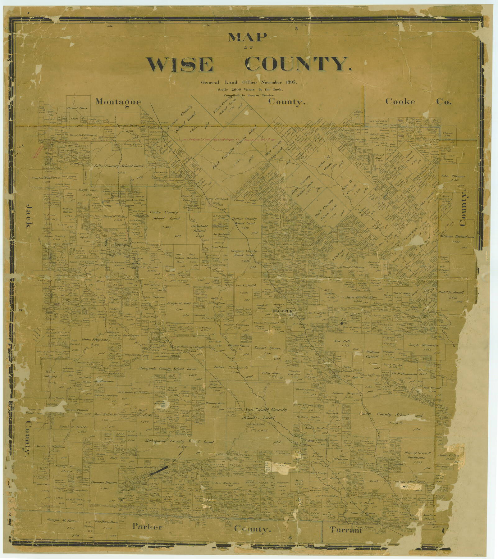
Map of Wise County
-
Map/Doc
16932
-
Collection
General Map Collection
-
Object Dates
1895 (Creation Date)
-
People and Organizations
Texas General Land Office (Publisher)
Herman Pressler (Compiler)
-
Counties
Wise
-
Subjects
County
-
Height x Width
41.8 x 37.2 inches
106.2 x 94.5 cm
-
Comments
Conservation funded in 2004 with donations from Wes Mowery and Friends of the Texas General Land Office.
-
Features
Deep Creek
C&RI
Paradise
Center Creek
Herman
Oliver Creek
FW&DC
Willow Creek
Boggy Creek
Walnut Creek
Gentry Creek
Vale Creek
Garrett's Creek
Thompson Creek
Rhome
Elizabeth Creek
Durrett's Creek
Sunset
Sandy Creek
McCoys Creek
Martin's Creek
Denton Fork [of Trinity River]
Alvord
Pringles Creek
Bennett's Creek
Black Creek
Pecan Creek
Cowen
Chico
Big Sandy Creek
Beans Creek
West Fork of Trinity River
Long Branch [of Catlett Creek]
Catlett Creek
Sweetwater Creek
Decatur
Turkey Creek
Jasper Creek
Part of: General Map Collection
Concho County Rolled Sketch 11

Print $20.00
- Digital $50.00
Concho County Rolled Sketch 11
1957
Size 29.5 x 34.5 inches
Map/Doc 5569
Map of Blanco County

Print $20.00
- Digital $50.00
Map of Blanco County
1880
Size 23.9 x 18.2 inches
Map/Doc 3306
Sutton County Rolled Sketch H

Print $40.00
- Digital $50.00
Sutton County Rolled Sketch H
Size 24.9 x 50.0 inches
Map/Doc 9973
Gregg County Boundary File 3

Print $8.00
- Digital $50.00
Gregg County Boundary File 3
Size 14.1 x 8.5 inches
Map/Doc 53988
Flight Mission No. CLL-3N, Frame 10, Willacy County

Print $20.00
- Digital $50.00
Flight Mission No. CLL-3N, Frame 10, Willacy County
1954
Size 18.5 x 22.2 inches
Map/Doc 87076
[Gulf Colorado & Santa Fe from 2178+36.0 to 3901+06.2]
![64697, [Gulf Colorado & Santa Fe from 2178+36.0 to 3901+06.2], General Map Collection](https://historictexasmaps.com/wmedia_w700/maps/64697-1.tif.jpg)
Print $40.00
- Digital $50.00
[Gulf Colorado & Santa Fe from 2178+36.0 to 3901+06.2]
Size 33.2 x 121.6 inches
Map/Doc 64697
Flight Mission No. DQN-1K, Frame 48, Calhoun County

Print $20.00
- Digital $50.00
Flight Mission No. DQN-1K, Frame 48, Calhoun County
1953
Size 17.3 x 18.6 inches
Map/Doc 84148
[Surveys in the Bexar District along the Sabinal River and Rancheros Creek]
![95, [Surveys in the Bexar District along the Sabinal River and Rancheros Creek], General Map Collection](https://historictexasmaps.com/wmedia_w700/maps/95.tif.jpg)
Print $2.00
- Digital $50.00
[Surveys in the Bexar District along the Sabinal River and Rancheros Creek]
1846
Size 8.6 x 7.8 inches
Map/Doc 95
Rusk County Sketch File 27B

Print $20.00
Rusk County Sketch File 27B
1936
Size 15.4 x 19.9 inches
Map/Doc 12273
Taylor County Sketch File 11

Print $20.00
- Digital $50.00
Taylor County Sketch File 11
Size 34.8 x 28.3 inches
Map/Doc 10384
City of Alpine - Texas, Brewster County

Print $20.00
- Digital $50.00
City of Alpine - Texas, Brewster County
1945
Size 11.4 x 19.4 inches
Map/Doc 1683
Kendall County Boundary File 2

Print $4.00
- Digital $50.00
Kendall County Boundary File 2
Size 10.2 x 8.2 inches
Map/Doc 55746
You may also like
Rusk County Sketch File 18

Print $4.00
Rusk County Sketch File 18
Size 8.3 x 8.9 inches
Map/Doc 35524
Cogdell Ranch Kent County, Texas

Print $20.00
- Digital $50.00
Cogdell Ranch Kent County, Texas
1950
Size 36.3 x 19.2 inches
Map/Doc 92188
General Highway Map, Refugio County, Texas

Print $20.00
General Highway Map, Refugio County, Texas
1961
Size 18.1 x 24.7 inches
Map/Doc 79639
Cherokee County Working Sketch 17
Print $40.00
- Digital $50.00
Cherokee County Working Sketch 17
1958
Size 81.6 x 43.3 inches
Map/Doc 67972
Map of Martinsburg Property, Gillespie Co., Tex.

Print $20.00
- Digital $50.00
Map of Martinsburg Property, Gillespie Co., Tex.
Size 15.7 x 13.6 inches
Map/Doc 446
[Capitol Leagues 225-238]
![90677, [Capitol Leagues 225-238], Twichell Survey Records](https://historictexasmaps.com/wmedia_w700/maps/90677-1.tif.jpg)
Print $20.00
- Digital $50.00
[Capitol Leagues 225-238]
Size 23.2 x 13.0 inches
Map/Doc 90677
Smith County Rolled Sketch 2

Print $20.00
- Digital $50.00
Smith County Rolled Sketch 2
Size 36.2 x 34.6 inches
Map/Doc 76010
[Map of North Half of Hutchinson and South Half of Hansford Counties]
![92114, [Map of North Half of Hutchinson and South Half of Hansford Counties], Twichell Survey Records](https://historictexasmaps.com/wmedia_w700/maps/92114-1.tif.jpg)
Print $3.00
- Digital $50.00
[Map of North Half of Hutchinson and South Half of Hansford Counties]
Size 11.6 x 13.5 inches
Map/Doc 92114
[Blocks C-25, C-26, C-27, and 29]
![91320, [Blocks C-25, C-26, C-27, and 29], Twichell Survey Records](https://historictexasmaps.com/wmedia_w700/maps/91320-1.tif.jpg)
Print $20.00
- Digital $50.00
[Blocks C-25, C-26, C-27, and 29]
Size 23.4 x 27.2 inches
Map/Doc 91320
Irion County Rolled Sketch 8

Print $20.00
- Digital $50.00
Irion County Rolled Sketch 8
Size 42.9 x 34.1 inches
Map/Doc 9251
Montague County Working Sketch 28

Print $20.00
- Digital $50.00
Montague County Working Sketch 28
1963
Size 36.6 x 31.8 inches
Map/Doc 71094
Runnels County Rolled Sketch 44

Print $40.00
- Digital $50.00
Runnels County Rolled Sketch 44
Size 43.0 x 53.9 inches
Map/Doc 9871