Galveston County Rolled Sketch 39
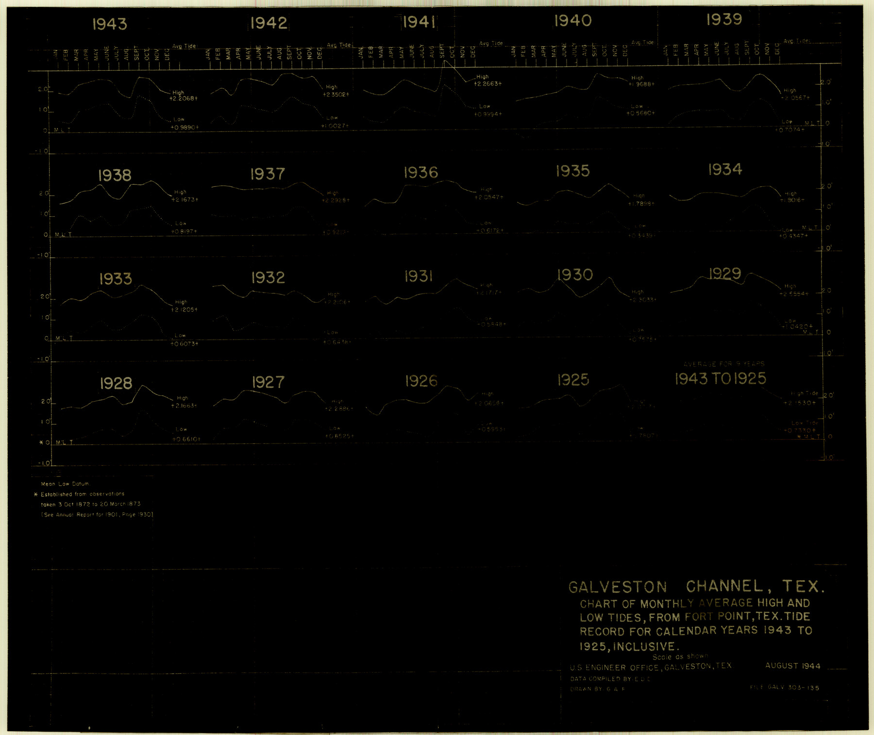
Galveston Channel, Chart of Monthly Average High and Low Tides, From Fort Point, Texas Tide Record for Calendar Years 1943 to 1925, Inclusive, Galveston County, Texas
-
Map/Doc
45207
-
Collection
General Map Collection
-
Counties
Galveston
-
Subjects
Surveying Rolled Sketch
-
Height x Width
18.1 x 21.5 inches
46.0 x 54.6 cm
Part of: General Map Collection
San Luis Pass to Matagorda Bay

Print $20.00
- Digital $50.00
San Luis Pass to Matagorda Bay
1946
Size 34.7 x 46.5 inches
Map/Doc 69961

Flight Mission No. DQN-1K, Frame 109, Calhoun County

Print $20.00
- Digital $50.00
Flight Mission No. DQN-1K, Frame 109, Calhoun County
1953
Size 18.4 x 22.1 inches
Map/Doc 84176
Andrews County Working Sketch 13

Print $20.00
- Digital $50.00
Andrews County Working Sketch 13
1956
Size 37.3 x 30.6 inches
Map/Doc 67059
Atascosa County Working Sketch 7

Print $3.00
- Digital $50.00
Atascosa County Working Sketch 7
1913
Size 14.0 x 9.4 inches
Map/Doc 67203
McLennan County Sketch File 11

Print $8.00
- Digital $50.00
McLennan County Sketch File 11
1860
Size 9.0 x 7.7 inches
Map/Doc 31262
Martin County Working Sketch 11

Print $40.00
- Digital $50.00
Martin County Working Sketch 11
1971
Size 49.8 x 38.1 inches
Map/Doc 70829
Flight Mission No. DIX-5P, Frame 117, Aransas County

Print $20.00
- Digital $50.00
Flight Mission No. DIX-5P, Frame 117, Aransas County
1956
Size 18.0 x 17.7 inches
Map/Doc 83796
Flight Mission No. DCL-5C, Frame 4, Kenedy County

Print $20.00
- Digital $50.00
Flight Mission No. DCL-5C, Frame 4, Kenedy County
1943
Size 18.6 x 22.5 inches
Map/Doc 85829
Dallam County Working Sketch Graphic Index

Print $40.00
- Digital $50.00
Dallam County Working Sketch Graphic Index
1926
Size 41.3 x 50.9 inches
Map/Doc 76516
Map of the Public Land States and Territories constructed from the Public Surveys and other official sources in the General Land Office

Print $20.00
- Digital $50.00
Map of the Public Land States and Territories constructed from the Public Surveys and other official sources in the General Land Office
1864
Size 31.0 x 46.6 inches
Map/Doc 94152
Map of Williamson County

Print $20.00
- Digital $50.00
Map of Williamson County
1876
Size 21.2 x 28.6 inches
Map/Doc 4152
You may also like
Bailey County Sketch File 9

Print $40.00
- Digital $50.00
Bailey County Sketch File 9
Size 22.4 x 18.1 inches
Map/Doc 10885
Crane County Working Sketch 7

Print $20.00
- Digital $50.00
Crane County Working Sketch 7
1929
Size 33.6 x 23.2 inches
Map/Doc 68284
Dallas County Sketch File 17

Print $20.00
- Digital $50.00
Dallas County Sketch File 17
Size 17.1 x 18.0 inches
Map/Doc 11285
Flight Mission No. DQN-7K, Frame 4, Calhoun County

Print $20.00
- Digital $50.00
Flight Mission No. DQN-7K, Frame 4, Calhoun County
1953
Size 18.9 x 22.1 inches
Map/Doc 84455
Concho County Working Sketch 2

Print $20.00
- Digital $50.00
Concho County Working Sketch 2
1915
Size 22.4 x 17.6 inches
Map/Doc 68184
Jim Wells County Working Sketch 11

Print $20.00
- Digital $50.00
Jim Wells County Working Sketch 11
1953
Size 20.4 x 22.6 inches
Map/Doc 66609
General Highway Map, Cass County, Texas

Print $20.00
General Highway Map, Cass County, Texas
1940
Size 18.6 x 25.2 inches
Map/Doc 79042
Coryell County Boundary File 22

Print $60.00
- Digital $50.00
Coryell County Boundary File 22
Size 7.2 x 3.7 inches
Map/Doc 51932
Mason County Working Sketch 14

Print $20.00
- Digital $50.00
Mason County Working Sketch 14
1959
Size 28.6 x 23.3 inches
Map/Doc 70850
Hardin County Sketch File 8

Print $8.00
- Digital $50.00
Hardin County Sketch File 8
1870
Size 12.6 x 8.1 inches
Map/Doc 25102
Dallam County Boundary File 4

Print $80.00
- Digital $50.00
Dallam County Boundary File 4
Size 9.4 x 49.8 inches
Map/Doc 52082
Irion County Working Sketch 10

Print $20.00
- Digital $50.00
Irion County Working Sketch 10
1940
Size 29.6 x 43.5 inches
Map/Doc 66419