Brazoria County NRC Article 33.136 Sketch 31
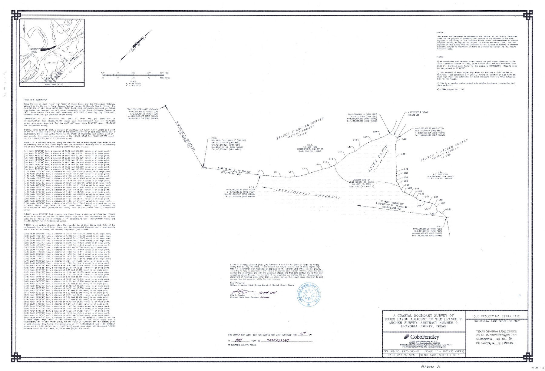
A Coastal Boundary Survey of Essex Bayou adjacent to the Branch T. Archer Survey, Abstract Number 9
-
Map/Doc
97476
-
Collection
General Map Collection
-
Object Dates
5/21/2025 (Creation Date)
7/8/2025 (File Date)
-
People and Organizations
Kyle C. Sunday (Surveyor/Engineer)
-
Counties
Brazoria
-
Subjects
Surveying CBS
-
Comments
Project: Essex Bayou - Branch T. Archer Survey, A-9 - Sunday
Project No.: CEPRA #1712
Part of: General Map Collection
Coke County Working Sketch 28

Print $20.00
- Digital $50.00
Coke County Working Sketch 28
1965
Size 32.7 x 42.2 inches
Map/Doc 68065
Map showing survey for proposed ship channel from Brownsville to Brazos Santiago Pass

Print $20.00
- Digital $50.00
Map showing survey for proposed ship channel from Brownsville to Brazos Santiago Pass
1912
Size 18.2 x 26.9 inches
Map/Doc 72898
Reeves County Rolled Sketch 33

Print $20.00
- Digital $50.00
Reeves County Rolled Sketch 33
Size 24.7 x 36.9 inches
Map/Doc 7501
Zavala County Sketch File 41

Print $20.00
- Digital $50.00
Zavala County Sketch File 41
1900
Size 24.0 x 21.6 inches
Map/Doc 12731
Karnes County Boundary File 6

Print $16.00
- Digital $50.00
Karnes County Boundary File 6
Size 9.3 x 4.0 inches
Map/Doc 55735
Fort Bend County Working Sketch 8

Print $20.00
- Digital $50.00
Fort Bend County Working Sketch 8
1922
Size 24.9 x 17.6 inches
Map/Doc 69214
Flight Mission No. CRC-4R, Frame 106, Chambers County

Print $20.00
- Digital $50.00
Flight Mission No. CRC-4R, Frame 106, Chambers County
1956
Size 18.6 x 22.3 inches
Map/Doc 84903
Bowie County Sketch File 7a

Print $30.00
- Digital $50.00
Bowie County Sketch File 7a
1927
Size 11.2 x 8.7 inches
Map/Doc 14854
Hudspeth County Rolled Sketch 38

Print $20.00
- Digital $50.00
Hudspeth County Rolled Sketch 38
1939
Size 18.0 x 37.5 inches
Map/Doc 6251
Brewster County Rolled Sketch 92

Print $20.00
- Digital $50.00
Brewster County Rolled Sketch 92
1950
Size 24.3 x 15.2 inches
Map/Doc 5250
Edwards County Working Sketch 44

Print $20.00
- Digital $50.00
Edwards County Working Sketch 44
1950
Size 44.1 x 26.0 inches
Map/Doc 68920
Brewster County Working Sketch 2

Print $20.00
- Digital $50.00
Brewster County Working Sketch 2
1907
Size 29.0 x 26.4 inches
Map/Doc 67535
You may also like
[Block C-41, Sections 32, 35, 35 1/2, and vicinity]
![92622, [Block C-41, Sections 32, 35, 35 1/2, and vicinity], Twichell Survey Records](https://historictexasmaps.com/wmedia_w700/maps/92622-1.tif.jpg)
Print $20.00
- Digital $50.00
[Block C-41, Sections 32, 35, 35 1/2, and vicinity]
1951
Size 20.8 x 9.1 inches
Map/Doc 92622
Reagan County Boundary File 2

Print $20.00
- Digital $50.00
Reagan County Boundary File 2
Size 17.5 x 32.4 inches
Map/Doc 58190
Leon County Working Sketch 41

Print $40.00
- Digital $50.00
Leon County Working Sketch 41
1980
Size 61.2 x 43.2 inches
Map/Doc 70440

Oldham County

Print $40.00
- Digital $50.00
Oldham County
1925
Size 42.6 x 51.5 inches
Map/Doc 77387
Callahan County Boundary File 1a

Print $4.00
- Digital $50.00
Callahan County Boundary File 1a
Size 13.3 x 8.7 inches
Map/Doc 51085
Travis County

Print $40.00
- Digital $50.00
Travis County
1880
Size 59.0 x 70.2 inches
Map/Doc 16902
Hardin County Rolled Sketch 3

Print $20.00
- Digital $50.00
Hardin County Rolled Sketch 3
1902
Size 20.1 x 17.0 inches
Map/Doc 6076
Cass County Working Sketch 40

Print $20.00
- Digital $50.00
Cass County Working Sketch 40
1984
Size 24.6 x 24.5 inches
Map/Doc 67943
[Showing west and north line of County]
![90652, [Showing west and north line of County], Twichell Survey Records](https://historictexasmaps.com/wmedia_w700/maps/90652-1.tif.jpg)
Print $20.00
- Digital $50.00
[Showing west and north line of County]
1885
Size 21.3 x 29.0 inches
Map/Doc 90652
Harris County Working Sketch 75

Print $20.00
- Digital $50.00
Harris County Working Sketch 75
1964
Size 29.7 x 32.3 inches
Map/Doc 65967
Flight Mission No. BRE-3P, Frame 38, Nueces County

Print $20.00
- Digital $50.00
Flight Mission No. BRE-3P, Frame 38, Nueces County
1956
Size 18.5 x 22.4 inches
Map/Doc 86816