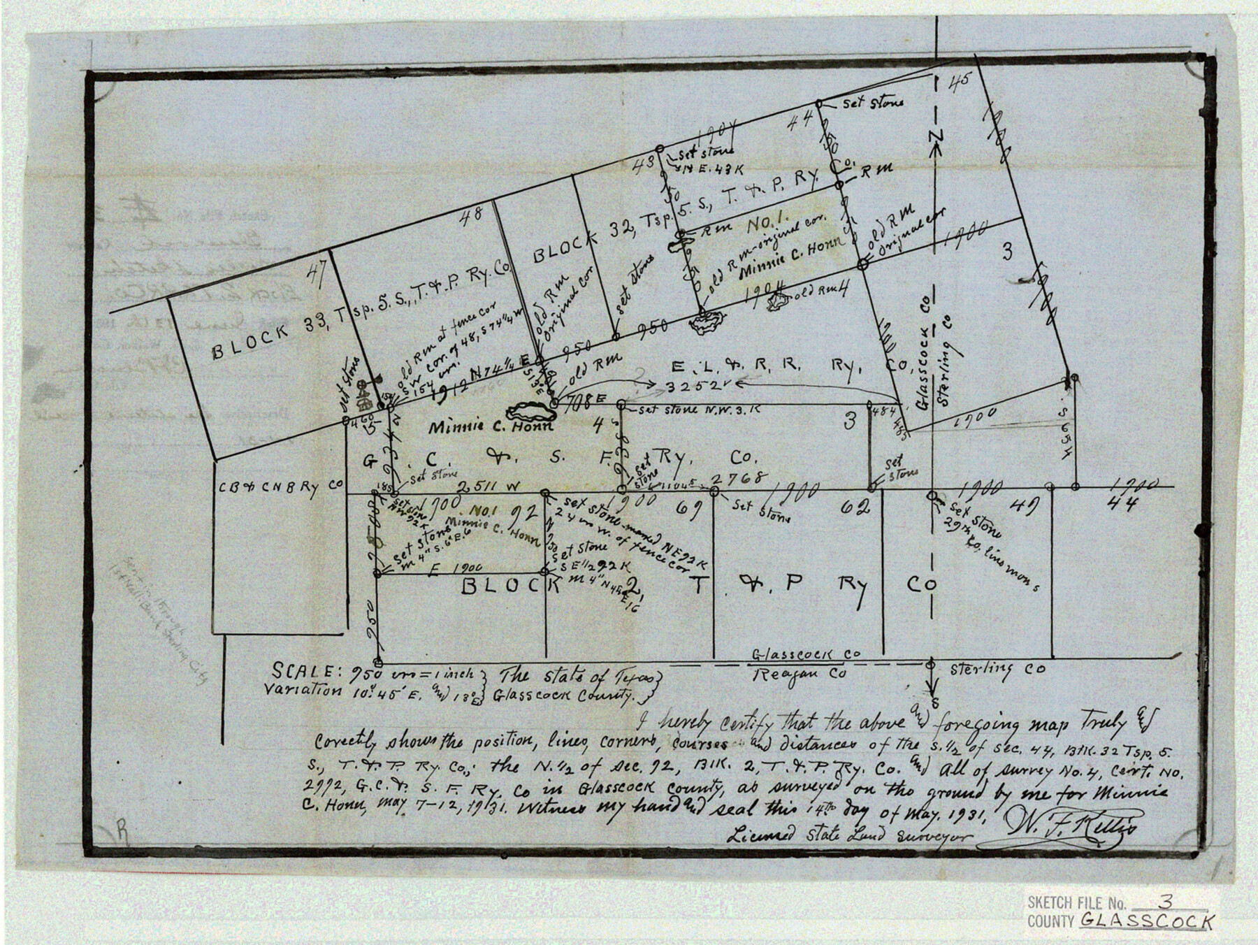
Glasscock County Sketch File 3
Block 2, T&RR Co.
-
Map/Doc
11560
-
Collection
General Map Collection
-
Object Dates
1931/6/13 (Creation Date)
1931/7/1 (File Date)
1931/5/12 (Survey Date)
-
People and Organizations
W.F. Kellis (Surveyor/Engineer)
-
Counties
Glasscock Sterling Reagan
-
Subjects
Surveying Sketch File
-
Height x Width
11.1 x 14.8 inches
28.2 x 37.6 cm
-
Medium
paper, manuscript
-
Scale
1:750
Part of: General Map Collection
Gaines County Rolled Sketch 12

Print $20.00
- Digital $50.00
Gaines County Rolled Sketch 12
1940
Size 26.6 x 33.8 inches
Map/Doc 5932
Presidio County Sketch File 61

Print $3.00
- Digital $50.00
Presidio County Sketch File 61
1930
Size 9.3 x 15.4 inches
Map/Doc 89987
Webb County Working Sketch 57

Print $20.00
- Digital $50.00
Webb County Working Sketch 57
1958
Size 24.9 x 38.0 inches
Map/Doc 72423
Falls County Sketch File 11a

Print $8.00
- Digital $50.00
Falls County Sketch File 11a
1871
Size 12.9 x 8.2 inches
Map/Doc 22358
Greer County Sketch File 11

Print $6.00
- Digital $50.00
Greer County Sketch File 11
Size 14.2 x 8.8 inches
Map/Doc 24532

Harris County Historic Topographic A

Print $20.00
- Digital $50.00
Harris County Historic Topographic A
1916
Size 26.1 x 19.0 inches
Map/Doc 65849
Hockley County Sketch File 1

Print $20.00
- Digital $50.00
Hockley County Sketch File 1
Size 20.3 x 18.9 inches
Map/Doc 11767
Ochiltree County Boundary File 10

Print $24.00
- Digital $50.00
Ochiltree County Boundary File 10
Size 11.2 x 8.7 inches
Map/Doc 57728
Flight Mission No. BQY-4M, Frame 119, Harris County

Print $20.00
- Digital $50.00
Flight Mission No. BQY-4M, Frame 119, Harris County
1953
Size 18.7 x 22.4 inches
Map/Doc 85287
Duval County Rolled Sketch 49
Print $20.00
- Digital $50.00
Duval County Rolled Sketch 49
1875
Size 17.8 x 17.6 inches
Map/Doc 5763
Liberty County Working Sketch 49a

Print $20.00
- Digital $50.00
Liberty County Working Sketch 49a
1955
Size 32.7 x 39.9 inches
Map/Doc 70508
You may also like
Grayson County Sketch File 21

Print $14.00
- Digital $50.00
Grayson County Sketch File 21
Size 7.7 x 17.8 inches
Map/Doc 24495
Map of Fannin County

Print $40.00
- Digital $50.00
Map of Fannin County
1841
Size 50.4 x 46.8 inches
Map/Doc 7821

Flight Mission No. DIX-5P, Frame 144, Aransas County

Print $20.00
- Digital $50.00
Flight Mission No. DIX-5P, Frame 144, Aransas County
1956
Size 17.2 x 17.6 inches
Map/Doc 83805
General Highway Map, Jeff Davis County, Texas

Print $20.00
General Highway Map, Jeff Davis County, Texas
1961
Size 18.3 x 24.6 inches
Map/Doc 79536
Fisher County Working Sketch 14

Print $20.00
- Digital $50.00
Fisher County Working Sketch 14
1957
Size 24.9 x 33.1 inches
Map/Doc 69148

Portion of States Submerged Area in Matagorda Bay

Print $20.00
- Digital $50.00
Portion of States Submerged Area in Matagorda Bay
1922
Size 15.2 x 14.8 inches
Map/Doc 2953
Live Oak County Working Sketch 32

Print $20.00
- Digital $50.00
Live Oak County Working Sketch 32
1992
Size 12.0 x 16.7 inches
Map/Doc 70617
[Beaumont, Sour Lake and Western Ry. Right of Way and Alignment - Frisco]
![64107, [Beaumont, Sour Lake and Western Ry. Right of Way and Alignment - Frisco], General Map Collection](https://historictexasmaps.com/wmedia_w700/maps/64107.tif.jpg)
Print $20.00
- Digital $50.00
[Beaumont, Sour Lake and Western Ry. Right of Way and Alignment - Frisco]
1910
Size 20.4 x 46.0 inches
Map/Doc 64107
Galveston The Year-'Round Resort

Galveston The Year-'Round Resort
1912
Size 7.8 x 10.2 inches
Map/Doc 97058
Oil and Gas Fields in the State of Texas

Print $40.00
Oil and Gas Fields in the State of Texas
1927
Size 58.0 x 38.0 inches
Map/Doc 76304