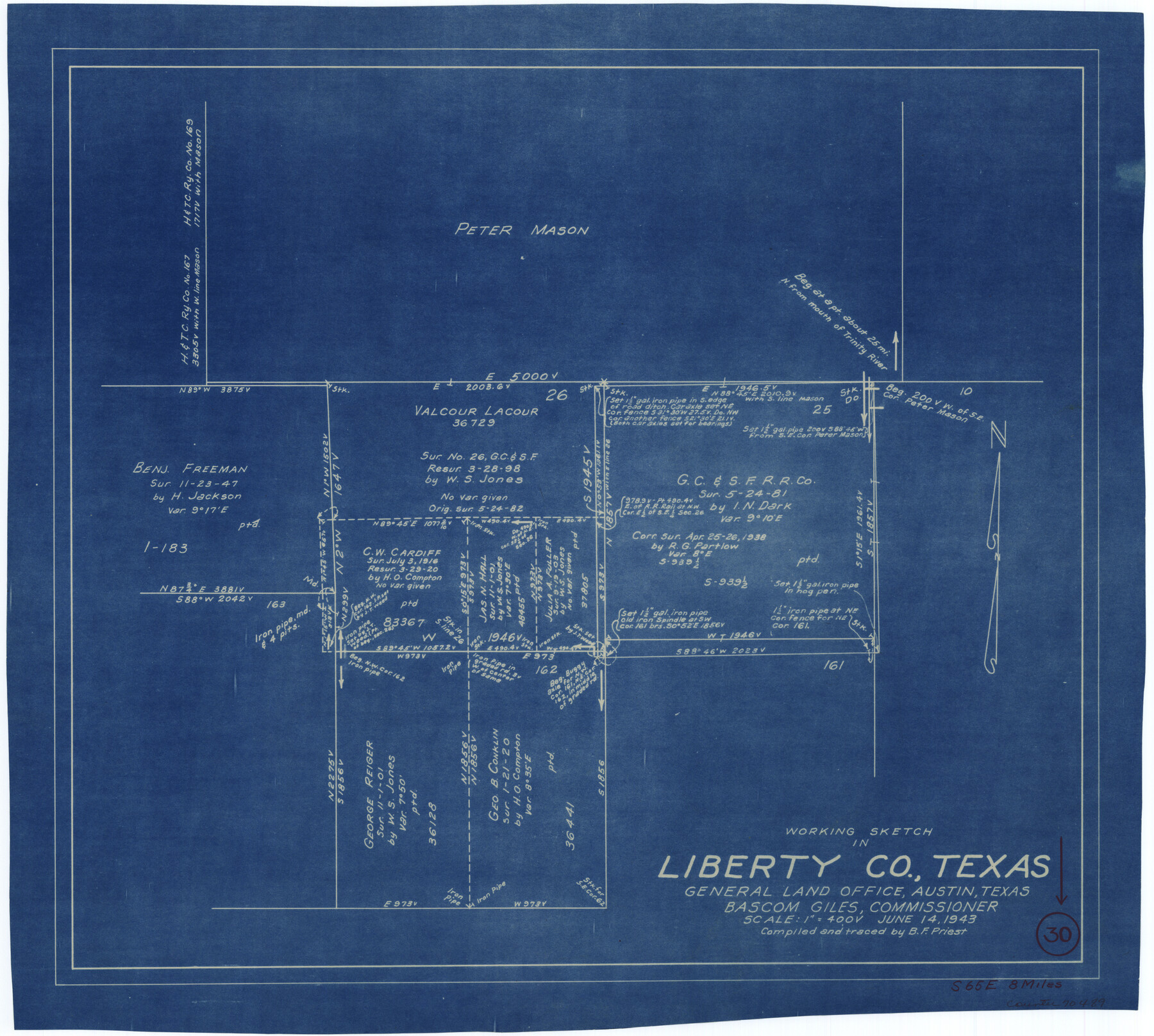
Liberty County Working Sketch 30
- 
                          Map/Doc
70489
 - 
                            Collection
General Map Collection
 - 
                            Object Dates
6/14/1943 (Creation Date)
 - 
                            People and Organizations
B.F. Priest (Draftsman)
 - 
                            Counties
Liberty
 - 
                            Subjects
Surveying Working Sketch
 - 
                            Height x Width
18.5 x 20.6 inches
47.0 x 52.3 cm
 - 
                            Scale
1" = 400 varas
 
Part of: General Map Collection
            Pecos County Rolled Sketch 147


                                            Print $449.00                    
                                             -                         Digital $50.00                                    
                Pecos County Rolled Sketch 147
1957
Size 10.1 x 15.4 inches
                                Map/Doc 48414
            
            Angelina County Working Sketch 22b


                                            Print $20.00                    
                                             -                         Digital $50.00                                    
                Angelina County Working Sketch 22b
1953
Size 21.5 x 19.6 inches
                                Map/Doc 67104
            
            Hamilton County Sketch File 5


                                            Print $4.00                    
                                             -                         Digital $50.00                                    
                Hamilton County Sketch File 5
Size 10.2 x 8.1 inches
                                Map/Doc 24908
            
            Pecos County Rolled Sketch 29


                                            Print $40.00                    
                                             -                         Digital $50.00                                    
                Pecos County Rolled Sketch 29
1890
Size 27.3 x 49.9 inches
                                Map/Doc 9690
            
            San Jacinto County Working Sketch 1


                                            Print $20.00                    
                                             -                         Digital $50.00                                    
                San Jacinto County Working Sketch 1
Size 30.0 x 29.6 inches
                                Map/Doc 63714
            
            Rusk County Working Sketch 6


                                            Print $20.00                    
                                             -                         Digital $50.00                                    
                Rusk County Working Sketch 6
1982
Size 32.8 x 32.9 inches
                                Map/Doc 63641
            
            Reagan County Boundary File 1d


                                            Print $36.00                    
                                             -                         Digital $50.00                                    
                Reagan County Boundary File 1d
Size 9.2 x 8.3 inches
                                Map/Doc 58181
            
            [Beaumont, Sour Lake and Western Ry. Right of Way and Alignment - Frisco]


                                            Print $20.00                    
                                             -                         Digital $50.00                                    
                [Beaumont, Sour Lake and Western Ry. Right of Way and Alignment - Frisco]
1910
Size 20.3 x 46.2 inches
                                Map/Doc 64131
            
            Souvenir - Opening and Dedication of the General Oil Company's New West Texas Oil Field


            Souvenir - Opening and Dedication of the General Oil Company's New West Texas Oil Field
1920
Map/Doc 97263
            
            Map of Drum, Oyster & Bastrop Bays & vicinity in Brazoria County showing subdivision for mineral development


                                            Print $20.00                    
                                             -                         Digital $50.00                                    
                Map of Drum, Oyster & Bastrop Bays & vicinity in Brazoria County showing subdivision for mineral development
Size 36.8 x 47.3 inches
                                Map/Doc 65808
            
            Flight Mission No. DAH-9M, Frame 161, Orange County


                                            Print $20.00                    
                                             -                         Digital $50.00                                    
                Flight Mission No. DAH-9M, Frame 161, Orange County
1953
Size 18.6 x 22.4 inches
                                Map/Doc 86860
            You may also like
            Trinity County Working Sketch 11


                                            Print $20.00                    
                                             -                         Digital $50.00                                    
                Trinity County Working Sketch 11
1949
Size 47.0 x 42.6 inches
                                Map/Doc 69460
            
            Roberts County Working Sketch 40


                                            Print $20.00                    
                                             -                         Digital $50.00                                    
                Roberts County Working Sketch 40
1978
Size 26.6 x 22.6 inches
                                Map/Doc 63566
            
            Bandera County Sketch File 33


                                            Print $40.00                    
                                             -                         Digital $50.00                                    
                Bandera County Sketch File 33
1975
Size 14.4 x 17.5 inches
                                Map/Doc 14028
            
            Flight Mission No. DIX-10P, Frame 71, Aransas County


                                            Print $20.00                    
                                             -                         Digital $50.00                                    
                Flight Mission No. DIX-10P, Frame 71, Aransas County
1956
Size 18.6 x 22.3 inches
                                Map/Doc 83932
            
            Real County Working Sketch 31


                                            Print $20.00                    
                                             -                         Digital $50.00                                    
                Real County Working Sketch 31
1948
Size 20.2 x 25.2 inches
                                Map/Doc 71923
            
            Platt [sic] of Late Surveys on Carancahua, Jackson County


                                            Print $2.00                    
                                             -                         Digital $50.00                                    
                Platt [sic] of Late Surveys on Carancahua, Jackson County
Size 10.9 x 8.0 inches
                                Map/Doc 78360
            
            Navarro County Sketch File 21


                                            Print $4.00                    
                                             -                         Digital $50.00                                    
                Navarro County Sketch File 21
1859
Size 9.0 x 8.4 inches
                                Map/Doc 32350
            
            Nautical Chart 152-SC - Galveston Bay, Texas


                                            Print $20.00                    
                                             -                         Digital $50.00                                    
                Nautical Chart 152-SC - Galveston Bay, Texas
1972
Size 15.2 x 33.5 inches
                                Map/Doc 69891
            
            [The S.K. Ry. of Texas, State Line to Pecos, Reeves Co., Texas]


                                            Print $40.00                    
                                             -                         Digital $50.00                                    
                [The S.K. Ry. of Texas, State Line to Pecos, Reeves Co., Texas]
1910
Size 19.2 x 120.9 inches
                                Map/Doc 64161
            
            Right of Way and Track Map, The Missouri, Kansas and Texas Ry. of Texas operated by the Missouri, Kansas and Texas Ry. of Texas, Henrietta Division


                                            Print $40.00                    
                                             -                         Digital $50.00                                    
                Right of Way and Track Map, The Missouri, Kansas and Texas Ry. of Texas operated by the Missouri, Kansas and Texas Ry. of Texas, Henrietta Division
1918
Size 24.8 x 56.3 inches
                                Map/Doc 64069
            
            Garza County Rolled Sketch 11


                                            Print $20.00                    
                                             -                         Digital $50.00                                    
                Garza County Rolled Sketch 11
1915
Size 31.6 x 20.8 inches
                                Map/Doc 6000
            
            Jefferson County Sketch File 49


                                            Print $40.00                    
                                             -                         Digital $50.00                                    
                Jefferson County Sketch File 49
1955
Size 51.1 x 29.0 inches
                                Map/Doc 10508